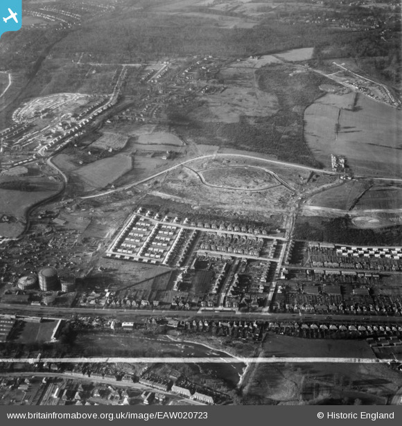
EAW020723 ENGLAND (1948). New housing development off Broomwood Road and the early stages of construction at Ravenscourt Road, St Paul's Cray, 1948. This image was marked by Aerofilms Ltd for photo editing.
© Copyright OpenStreetMap contributors and licensed by the OpenStreetMap Foundation. 2026. Cartography is licensed as CC BY-SA.
Details
| Title | [EAW020723] New housing development off Broomwood Road and the early stages of construction at Ravenscourt Road, St Paul's Cray, 1948. This image was marked by Aerofilms Ltd for photo editing. |
| Reference | EAW020723 |
| Date | 24-December-1948 |
| Link | |
| Place name | ST PAUL'S CRAY |
| Parish | |
| District | |
| Country | ENGLAND |
| Easting / Northing | 546613, 169016 |
| Longitude / Latitude | 0.10792211880794, 51.400706708908 |
| National Grid Reference | TQ466690 |
Pins

Broom1 |
Tuesday 16th of February 2016 09:33:16 PM | |

Gone2Kent |
Sunday 18th of May 2014 02:21:54 PM | |

Gone2Kent |
Sunday 18th of May 2014 02:20:44 PM | |

Gone2Kent |
Sunday 13th of April 2014 06:15:39 PM | |

Gone2Kent |
Sunday 16th of February 2014 05:02:05 PM | |

Gone2Kent |
Sunday 5th of January 2014 08:36:32 PM | |

Gone2Kent |
Sunday 5th of January 2014 08:35:28 PM | |

Gone2Kent |
Friday 27th of December 2013 07:23:57 AM |
User Comment Contributions
As the Broomwood now is |

Gone2Kent |
Sunday 26th of January 2014 09:40:47 AM |
Sevenoaks Way, (Orpington By Pass, A224, built 1926), goes from Left to Right, (South to North) about a quarter of the way up the picture. On the left is St Mary Cray Gas Works. Below Sevenoaks Way on the left is a lake formed by the river Cray. Above the Gas Works, Leesons Hill snakes up the picture, with Ravenscourt Rd and Clarendon way under development at the top left. Brooks Way runs up the picture from the right of the lake, becoming Broomwood Rd after crossing Sevenoaks Way, and in turn becomes Cotmandene Crescent as it bends at the top. It leads to Chipperfield Rd that runs from Leesons Hill across the middle of the picture. |

Gone2Kent |
Friday 27th of December 2013 07:37:33 AM |
Willett Memorial in Petts Wood |

Gone2Kent |
Friday 27th of December 2013 07:28:15 AM |
Willett Memorial in Petts Wood |

Gone2Kent |
Friday 27th of December 2013 07:27:08 AM |


![[EAW020723] New housing development off Broomwood Road and the early stages of construction at Ravenscourt Road, St Paul's Cray, 1948. This image was marked by Aerofilms Ltd for photo editing.](http://britainfromabove.org.uk/sites/all/libraries/aerofilms-images/public/100x100/EAW/020/EAW020723.jpg)
![[EAW020735] New housing development around Saxville Road and the early stages of contstruction at Ravenscourt Road, St Paul's Cray, 1948](http://britainfromabove.org.uk/sites/all/libraries/aerofilms-images/public/100x100/EAW/020/EAW020735.jpg)