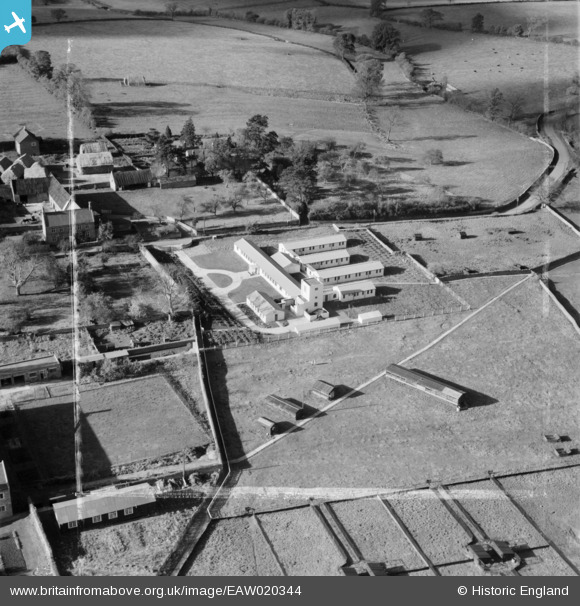
EAW020344 ENGLAND (1948). Northamptonshire Institute of Agriculture, Moulton, 1948. This image was marked by Aerofilms Ltd for photo editing.
© Copyright OpenStreetMap contributors and licensed by the OpenStreetMap Foundation. 2024. Cartography is licensed as CC BY-SA.
Nearby Images (19)
Details
| Title | [EAW020344] Northamptonshire Institute of Agriculture, Moulton, 1948. This image was marked by Aerofilms Ltd for photo editing. |
| Reference | EAW020344 |
| Date | 4-November-1948 |
| Link | |
| Place name | MOULTON |
| Parish | MOULTON |
| District | |
| Country | ENGLAND |
| Easting / Northing | 477944, 266462 |
| Longitude / Latitude | -0.85708914927463, 52.29036507339 |
| National Grid Reference | SP779665 |
Pins
Be the first to add a comment to this image!


![[EAW020344] Northamptonshire Institute of Agriculture, Moulton, 1948. This image was marked by Aerofilms Ltd for photo editing.](http://britainfromabove.org.uk/sites/all/libraries/aerofilms-images/public/100x100/EAW/020/EAW020344.jpg)
![[EAW020355] Northamptonshire Institute of Agriculture and Moulton Grounds Farm, Moulton, from the south-east, 1948](http://britainfromabove.org.uk/sites/all/libraries/aerofilms-images/public/100x100/EAW/020/EAW020355.jpg)
![[EAW020349] Northamptonshire Institute of Agriculture, Moulton, 1948. This image was marked by Aerofilms Ltd for photo editing.](http://britainfromabove.org.uk/sites/all/libraries/aerofilms-images/public/100x100/EAW/020/EAW020349.jpg)
![[EAW020356] Northamptonshire Institute of Agriculture and Moulton Grounds Farm, Moulton, from the south-east, 1948. This image was marked by Aerofilms Ltd for photo editing.](http://britainfromabove.org.uk/sites/all/libraries/aerofilms-images/public/100x100/EAW/020/EAW020356.jpg)
![[EAW020347] Northamptonshire Institute of Agriculture, Moulton, 1948](http://britainfromabove.org.uk/sites/all/libraries/aerofilms-images/public/100x100/EAW/020/EAW020347.jpg)
![[EAW020346] Northamptonshire Institute of Agriculture, Moulton, from the east, 1948. This image was marked by Aerofilms Ltd for photo editing.](http://britainfromabove.org.uk/sites/all/libraries/aerofilms-images/public/100x100/EAW/020/EAW020346.jpg)
![[EAW020345] Northamptonshire Institute of Agriculture, Moulton, 1948. This image was marked by Aerofilms Ltd for photo editing.](http://britainfromabove.org.uk/sites/all/libraries/aerofilms-images/public/100x100/EAW/020/EAW020345.jpg)
![[EAW020348] Northamptonshire Institute of Agriculture, Moulton, 1948. This image was marked by Aerofilms Ltd for photo editing.](http://britainfromabove.org.uk/sites/all/libraries/aerofilms-images/public/100x100/EAW/020/EAW020348.jpg)
![[EAW027206] The Northamptonshire Institute of Agriculture, Moulton, 1949. This image has been produced from a print.](http://britainfromabove.org.uk/sites/all/libraries/aerofilms-images/public/100x100/EAW/027/EAW027206.jpg)
![[EAW027208] The Northamptonshire Institute of Agriculture, Moulton, 1949. This image was marked by Aerofilms Ltd for photo editing.](http://britainfromabove.org.uk/sites/all/libraries/aerofilms-images/public/100x100/EAW/027/EAW027208.jpg)
![[EAW027209] The Northamptonshire Institute of Agriculture, Moulton, 1949. This image was marked by Aerofilms Ltd for photo editing.](http://britainfromabove.org.uk/sites/all/libraries/aerofilms-images/public/100x100/EAW/027/EAW027209.jpg)
![[EAW027210] The Northamptonshire Institute of Agriculture, Moulton, 1949. This image was marked by Aerofilms Ltd for photo editing.](http://britainfromabove.org.uk/sites/all/libraries/aerofilms-images/public/100x100/EAW/027/EAW027210.jpg)
![[EAW027211] The Northamptonshire Institute of Agriculture, Moulton, 1949. This image was marked by Aerofilms Ltd for photo editing.](http://britainfromabove.org.uk/sites/all/libraries/aerofilms-images/public/100x100/EAW/027/EAW027211.jpg)
![[EAW027207] The Northamptonshire Institute of Agriculture, Moulton, 1949. This image has been produced from a print marked by Aerofilms Ltd for photo editing.](http://britainfromabove.org.uk/sites/all/libraries/aerofilms-images/public/100x100/EAW/027/EAW027207.jpg)
![[EAW020357] Northamptonshire Institute of Agriculture and Moulton Grounds Farm, Moulton, 1948](http://britainfromabove.org.uk/sites/all/libraries/aerofilms-images/public/100x100/EAW/020/EAW020357.jpg)
![[EAW027205] The Northamptonshire Institute of Agriculture, Moulton, from the south, 1949. This image has been produced from a print marked by Aerofilms Ltd for photo editing.](http://britainfromabove.org.uk/sites/all/libraries/aerofilms-images/public/100x100/EAW/027/EAW027205.jpg)
![[EAW020358] Northamptonshire Institute of Agriculture and Moulton Grounds Farm, Moulton, 1948](http://britainfromabove.org.uk/sites/all/libraries/aerofilms-images/public/100x100/EAW/020/EAW020358.jpg)
![[EAW020352] Moulton Grounds Farm, Moulton, from the south-east, 1948](http://britainfromabove.org.uk/sites/all/libraries/aerofilms-images/public/100x100/EAW/020/EAW020352.jpg)
![[EAW020351] Moulton Grounds Farm, Moulton, from the south, 1948](http://britainfromabove.org.uk/sites/all/libraries/aerofilms-images/public/100x100/EAW/020/EAW020351.jpg)