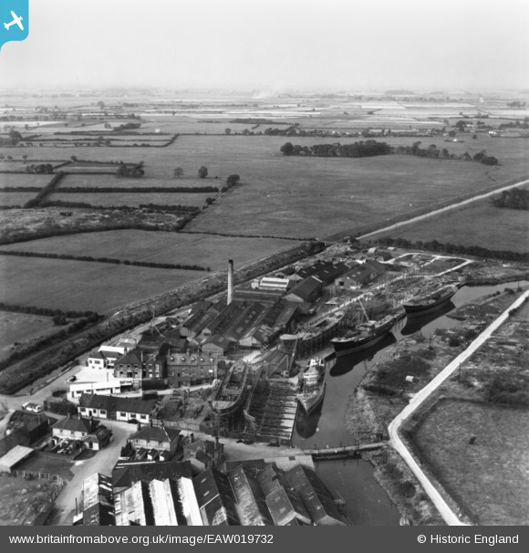
EAW019732 ENGLAND (1948). The Cook, Welton and Gemmell Ltd Shipbuilding Yard and environs, Beverley, from the south-east, 1948. This image has been produced from a print.
© Copyright OpenStreetMap contributors and licensed by the OpenStreetMap Foundation. 2024. Cartography is licensed as CC BY-SA.
Nearby Images (14)
Details
| Title | [EAW019732] The Cook, Welton and Gemmell Ltd Shipbuilding Yard and environs, Beverley, from the south-east, 1948. This image has been produced from a print. |
| Reference | EAW019732 |
| Date | 6-October-1948 |
| Link | |
| Place name | BEVERLEY |
| Parish | BEVERLEY |
| District | |
| Country | ENGLAND |
| Easting / Northing | 505342, 439812 |
| Longitude / Latitude | -0.39871673363975, 53.843645074852 |
| National Grid Reference | TA053398 |
Pins
 John Wass |
Wednesday 26th of October 2016 04:45:54 PM |


![[EAW019732] The Cook, Welton and Gemmell Ltd Shipbuilding Yard and environs, Beverley, from the south-east, 1948. This image has been produced from a print.](http://britainfromabove.org.uk/sites/all/libraries/aerofilms-images/public/100x100/EAW/019/EAW019732.jpg)
![[EAW019734] The Cook, Welton and Gemmell Ltd Shipbuilding Yard and environs, Beverley, from the south, 1948. This image has been produced from a print.](http://britainfromabove.org.uk/sites/all/libraries/aerofilms-images/public/100x100/EAW/019/EAW019734.jpg)
![[EAW018610] The Cook, Welton and Gemmell Ltd Shipbuilding Yard, Beverley, from the south, 1948. This image has been produced from a print.](http://britainfromabove.org.uk/sites/all/libraries/aerofilms-images/public/100x100/EAW/018/EAW018610.jpg)
![[EAW018608] The Cook, Welton and Gemmell Ltd Shipbuilding Yard, Beverley, from the south, 1948. This image has been produced from a print.](http://britainfromabove.org.uk/sites/all/libraries/aerofilms-images/public/100x100/EAW/018/EAW018608.jpg)
![[EAW018612] The Cook, Welton and Gemmell Ltd Shipbuilding Yard and environs, Beverley, from the south-west, 1948. This image has been produced from a print.](http://britainfromabove.org.uk/sites/all/libraries/aerofilms-images/public/100x100/EAW/018/EAW018612.jpg)
![[EAW019735] The Cook, Welton and Gemmell Ltd Shipbuilding Yard and environs, Beverley, from the south, 1948. This image has been produced from a print marked by Aerofilms Lrd for photo editing.](http://britainfromabove.org.uk/sites/all/libraries/aerofilms-images/public/100x100/EAW/019/EAW019735.jpg)
![[EAW018611] The Cook, Welton and Gemmell Ltd Shipbuilding Yard and environs, Beverley, from the south, 1948. This image has been produced from a print marked by Aerofilms Ltd for photo editing.](http://britainfromabove.org.uk/sites/all/libraries/aerofilms-images/public/100x100/EAW/018/EAW018611.jpg)
![[EAW019730] The Cook, Welton and Gemmell Ltd Shipbuilding Yard, Beverley, 1948. This image has been produced from a print marked by Aerofilms Ltd for photo editing.](http://britainfromabove.org.uk/sites/all/libraries/aerofilms-images/public/100x100/EAW/019/EAW019730.jpg)
![[EAW018614] The Cook, Welton and Gemmell Ltd Shipbuilding Yard, Tickton, from the north-east, 1948. This image has been produced from a print.](http://britainfromabove.org.uk/sites/all/libraries/aerofilms-images/public/100x100/EAW/018/EAW018614.jpg)
![[EAW018615] The Cook, Welton and Gemmell Ltd Shipbuilding Yard, Beverley, from the north, 1948. This image has been produced from a print.](http://britainfromabove.org.uk/sites/all/libraries/aerofilms-images/public/100x100/EAW/018/EAW018615.jpg)
![[EAW019731] The Cook, Welton and Gemmell Ltd Shipbuilding Yard and environs, Beverley, from the north, 1948. This image has been produced from a print marked by Aerofilms Ltd for photo editing.](http://britainfromabove.org.uk/sites/all/libraries/aerofilms-images/public/100x100/EAW/019/EAW019731.jpg)
![[EAW018607] The Cook, Welton and Gemmell Ltd Shipbuilding Yard, Grovehill Road and environs, Beverley, from the west, 1948. This image has been produced from a print marked by Aerofilms Ltd for photo editing.](http://britainfromabove.org.uk/sites/all/libraries/aerofilms-images/public/100x100/EAW/018/EAW018607.jpg)
![[EAW018613] The Cook, Welton and Gemmell Ltd Shipbuilding Yard, Grovehill Road and environs, Beverley, from the west, 1948. This image has been produced from a print marked by Aerofilms Ltd for photo editing.](http://britainfromabove.org.uk/sites/all/libraries/aerofilms-images/public/100x100/EAW/018/EAW018613.jpg)
![[EAW018609] The Cook, Welton and Gemmell Ltd Shipbuilding Yard, Grovehill Road and environs, Beverley, from the south-west, 1948. This image has been produced from a print marked by Aerofilms Ltd for photo editing.](http://britainfromabove.org.uk/sites/all/libraries/aerofilms-images/public/100x100/EAW/018/EAW018609.jpg)