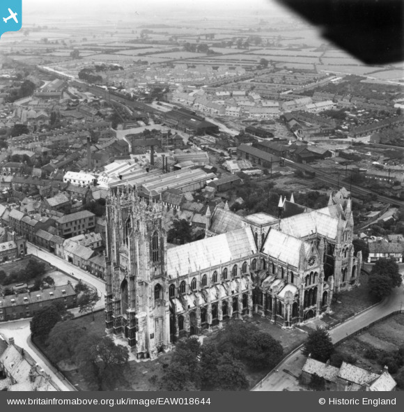
EAW018644 ENGLAND (1948). The Minster and environs, Beverley, 1948. This image has been produced from a print.
© Copyright OpenStreetMap contributors and licensed by the OpenStreetMap Foundation. 2026. Cartography is licensed as CC BY-SA.
Nearby Images (30)
Details
| Title | [EAW018644] The Minster and environs, Beverley, 1948. This image has been produced from a print. |
| Reference | EAW018644 |
| Date | 10-September-1948 |
| Link | |
| Place name | BEVERLEY |
| Parish | BEVERLEY |
| District | |
| Country | ENGLAND |
| Easting / Northing | 503756, 439408 |
| Longitude / Latitude | -0.42295152552337, 53.840334156628 |
| National Grid Reference | TA038394 |
Pins

John Wass |
Wednesday 26th of October 2016 04:42:22 PM |


![[EAW018644] The Minster and environs, Beverley, 1948. This image has been produced from a print.](http://britainfromabove.org.uk/sites/all/libraries/aerofilms-images/public/100x100/EAW/018/EAW018644.jpg)
![[EAW018619] The Armstrong's Patents Co Ltd Engineering Works and Goods Shed, Beverley, from the south-west, 1948. This image was marked by Aerofilms Ltd for photo editing.](http://britainfromabove.org.uk/sites/all/libraries/aerofilms-images/public/100x100/EAW/018/EAW018619.jpg)
![[EAW018621] The Armstrong's Patents Co Ltd Engineering Works and Goods Shed, Beverley, from the south-west, 1948. This image was marked by Aerofilms Ltd for photo editing.](http://britainfromabove.org.uk/sites/all/libraries/aerofilms-images/public/100x100/EAW/018/EAW018621.jpg)
![[EAW018618] The Armstrong's Patents Co Ltd Engineering Works and Goods Shed, Beverley, from the west, 1948. This image has been produced from a damaged negative.](http://britainfromabove.org.uk/sites/all/libraries/aerofilms-images/public/100x100/EAW/018/EAW018618.jpg)
![[EAW018622] The Armstrong's Patents Co Ltd Engineering Works and Goods Shed, Beverley, from the west, 1948. This image was marked by Aerofilms Ltd for photo editing.](http://britainfromabove.org.uk/sites/all/libraries/aerofilms-images/public/100x100/EAW/018/EAW018622.jpg)
![[EAW018623] The Armstrong's Patents Co Ltd Engineering Works and the town centre, Beverley, 1948. This image was marked by Aerofilms Ltd for photo editing.](http://britainfromabove.org.uk/sites/all/libraries/aerofilms-images/public/100x100/EAW/018/EAW018623.jpg)
![[EAW018624] The Armstrong's Patents Co Ltd Engineering Works and The Minster, Beverley, 1948](http://britainfromabove.org.uk/sites/all/libraries/aerofilms-images/public/100x100/EAW/018/EAW018624.jpg)
![[EAW004523] Hodgson's Tannery and Glue Works and environs, Beverley, from the north-west, 1947. This image was marked by Aerofilms Ltd for photo editing.](http://britainfromabove.org.uk/sites/all/libraries/aerofilms-images/public/100x100/EAW/004/EAW004523.jpg)
![[EAW035017] The Minster and the town, Beverley, 1951](http://britainfromabove.org.uk/sites/all/libraries/aerofilms-images/public/100x100/EAW/035/EAW035017.jpg)
![[EAW004518] Hodgson's Tannery and Glue Works, Beverley, from the north-west, 1947. This image was marked by Aerofilms Ltd for photo editing.](http://britainfromabove.org.uk/sites/all/libraries/aerofilms-images/public/100x100/EAW/004/EAW004518.jpg)
![[EAW018616] The Armstrong's Patents Co Ltd Engineering Works and environs, Beverley, 1948. This image has been produced from a print marked by Aerofilms Ltd for photo editing.](http://britainfromabove.org.uk/sites/all/libraries/aerofilms-images/public/100x100/EAW/018/EAW018616.jpg)
![[EAW004524] The Minster, Hodgson's Tannery and Glue Works and environs, Beverley, from the west, 1947](http://britainfromabove.org.uk/sites/all/libraries/aerofilms-images/public/100x100/EAW/004/EAW004524.jpg)
![[EAW018620] The Armstrong's Patents Co Ltd Engineering Works, the Railway Station and the surrounding residential area, Beverley, 1948. This image was marked by Aerofilms Ltd for photo editing.](http://britainfromabove.org.uk/sites/all/libraries/aerofilms-images/public/100x100/EAW/018/EAW018620.jpg)
![[EAW018625] The Armstrong's Patents Co Ltd Engineering Works and Goods Shed, Beverley, 1948. This image was marked by Aerofilms Ltd for photo editing.](http://britainfromabove.org.uk/sites/all/libraries/aerofilms-images/public/100x100/EAW/018/EAW018625.jpg)
![[EPW023166] The Minster or Collegiate Church of St John, Beverley, 1928](http://britainfromabove.org.uk/sites/all/libraries/aerofilms-images/public/100x100/EPW/023/EPW023166.jpg)
![[EAW018617] The Armstrong's Patents Co Ltd Engineering Works and Goods Shed, Beverley, 1948. This image has been produced from a print marked by Aerofilms Ltd for photo editing.](http://britainfromabove.org.uk/sites/all/libraries/aerofilms-images/public/100x100/EAW/018/EAW018617.jpg)
![[EAW035018] The Minster, Beverley, 1951](http://britainfromabove.org.uk/sites/all/libraries/aerofilms-images/public/100x100/EAW/035/EAW035018.jpg)
![[EPW012710] The Minster, Beverley, 1925](http://britainfromabove.org.uk/sites/all/libraries/aerofilms-images/public/100x100/EPW/012/EPW012710.jpg)
![[EPW023168] The Minster or Collegiate Church of St John and environs, Beverley, 1928](http://britainfromabove.org.uk/sites/all/libraries/aerofilms-images/public/100x100/EPW/023/EPW023168.jpg)
![[EPW012711] The Minster and environs, Beverley, 1925](http://britainfromabove.org.uk/sites/all/libraries/aerofilms-images/public/100x100/EPW/012/EPW012711.jpg)
![[EAW035019] The Minster, Beverley, 1951](http://britainfromabove.org.uk/sites/all/libraries/aerofilms-images/public/100x100/EAW/035/EAW035019.jpg)
![[EPW023161] The Minster or Collegiate Church of St John, Beverley, 1928](http://britainfromabove.org.uk/sites/all/libraries/aerofilms-images/public/100x100/EPW/023/EPW023161.jpg)
![[EPW023167] The Minster and Hodgson's Tannery, Beverley, 1928](http://britainfromabove.org.uk/sites/all/libraries/aerofilms-images/public/100x100/EPW/023/EPW023167.jpg)
![[EAW004519] Hodgson's Tannery and Glue Works and environs, Beverley, from the south-west, 1947](http://britainfromabove.org.uk/sites/all/libraries/aerofilms-images/public/100x100/EAW/004/EAW004519.jpg)
![[EAW004520] Hodgson's Tannery and Glue Works and environs, Beverley, from the north-west, 1947](http://britainfromabove.org.uk/sites/all/libraries/aerofilms-images/public/100x100/EAW/004/EAW004520.jpg)
![[EPW023169] The Minster and Hodgson's Tannery, Beverley, 1928](http://britainfromabove.org.uk/sites/all/libraries/aerofilms-images/public/100x100/EPW/023/EPW023169.jpg)
![[EPW023165] The Minster and Hodgson's Tannery, Beverley, 1928](http://britainfromabove.org.uk/sites/all/libraries/aerofilms-images/public/100x100/EPW/023/EPW023165.jpg)
![[EPW023164] The Minster and Hodgson's Tannery, Beverley, 1928](http://britainfromabove.org.uk/sites/all/libraries/aerofilms-images/public/100x100/EPW/023/EPW023164.jpg)
![[EPW023162] The Minster and Hodgson's Tannery, Beverley, 1928](http://britainfromabove.org.uk/sites/all/libraries/aerofilms-images/public/100x100/EPW/023/EPW023162.jpg)
![[EAW004517] Hodgson's Tannery and Glue Works and environs, Beverley, from the south-west, 1947](http://britainfromabove.org.uk/sites/all/libraries/aerofilms-images/public/100x100/EAW/004/EAW004517.jpg)