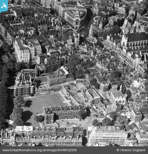
EAW018336 ENGLAND (1948). The Temple, London, 1948. This image has been produced from a print.
    © Copyright OpenStreetMap contributors and licensed by the OpenStreetMap Foundation. 2025. Cartography is licensed as CC BY-SA.
  
Nearby Images (19)
Details
| Title | [EAW018336] The Temple, London, 1948. This image has been produced from a print. | 
| Reference | EAW018336 | 
| Date | 27-August-1948 | 
| Link | |
| Place name | LONDON | 
| Parish | |
| District | |
| Country | ENGLAND | 
| Easting / Northing | 531157, 180979 | 
| Longitude / Latitude | -0.10972125486325, 51.512011532258 | 
| National Grid Reference | TQ312810 | 
Pins
|   Alan McFaden | Tuesday 7th of October 2014 02:45:56 PM | |
|   Alan McFaden | Tuesday 7th of October 2014 02:45:21 PM | |
|   Alan McFaden | Tuesday 7th of October 2014 02:44:24 PM | |
|   Alan McFaden | Tuesday 7th of October 2014 02:43:38 PM | |
|   Alan McFaden | Tuesday 7th of October 2014 02:42:42 PM | |
|   Alan McFaden | Tuesday 7th of October 2014 02:42:01 PM | |
|  Aldwych, WC2 |   billyfern | Saturday 4th of October 2014 03:17:34 PM | 
 
             
  ![[EAW018336] The Temple, London, 1948. This image has been produced from a print.](http://britainfromabove.org.uk/sites/all/libraries/aerofilms-images/public/100x100/EAW/018/EAW018336.jpg) 
  
                                          ![[EAW021426] Inner and Middle Temples, Lincoln's Inn and environs, London, 1949. This image has been produced from a print.](http://britainfromabove.org.uk/sites/all/libraries/aerofilms-images/public/100x100/EAW/021/EAW021426.jpg) 
 ![[EAW021424] Lincoln's Inn, the River Thames and surrounding city, London, 1949. This image has been produced from a print.](http://britainfromabove.org.uk/sites/all/libraries/aerofilms-images/public/100x100/EAW/021/EAW021424.jpg) 
 ![[EPW028598] The Victoria Embankment between Waterloo Bridge and Blackfriars Bridge, Strand, 1929](http://britainfromabove.org.uk/sites/all/libraries/aerofilms-images/public/100x100/EPW/028/EPW028598.jpg) 
 ![[EPW028600] The Victoria Embankment between Waterloo Bridge and Blackfriars Bridge and environs, Strand, 1929.  This image was marked by Aerofilms for photo editing.](http://britainfromabove.org.uk/sites/all/libraries/aerofilms-images/public/100x100/EPW/028/EPW028600.jpg) 
 ![[EAW004905] The Royal Courts of Justice (the Law Courts) and environs, Strand, 1947](http://britainfromabove.org.uk/sites/all/libraries/aerofilms-images/public/100x100/EAW/004/EAW004905.jpg) 
 ![[EAW004904] Inner Temple and environs including bomb damage and cleared areas, London, 1947](http://britainfromabove.org.uk/sites/all/libraries/aerofilms-images/public/100x100/EAW/004/EAW004904.jpg) 
 ![[EPW028601] The Victoria Embankment between Waterloo Bridge and Blackfriars Bridge and environs, Strand, 1929](http://britainfromabove.org.uk/sites/all/libraries/aerofilms-images/public/100x100/EPW/028/EPW028601.jpg) 
 ![[EPW005907] St Clement Danes Church, Strand, 1921. This image has been produced from a print.](http://britainfromabove.org.uk/sites/all/libraries/aerofilms-images/public/100x100/EPW/005/EPW005907.jpg) 
 ![[EAW018347] Fleet Street, London, 1948. This image has been produced from a print.](http://britainfromabove.org.uk/sites/all/libraries/aerofilms-images/public/100x100/EAW/018/EAW018347.jpg) 
 ![[EAW033361] Fleet Street, Chancery Lane and environs, London, 1950](http://britainfromabove.org.uk/sites/all/libraries/aerofilms-images/public/100x100/EAW/033/EAW033361.jpg) 
 ![[EPW028599] The Victoria Embankment between Waterloo Bridge and Blackfriars Bridge and environs, Holborn, 1929](http://britainfromabove.org.uk/sites/all/libraries/aerofilms-images/public/100x100/EPW/028/EPW028599.jpg) 
 ![[EAW048074] A fog covered cityscape from Waterloo Bridge to Tower Bridge, London, from the west, 1952. This image has been produced from a print.](http://britainfromabove.org.uk/sites/all/libraries/aerofilms-images/public/100x100/EAW/048/EAW048074.jpg) 
 ![[EAW011161] The Royal Courts of Justice and environs, Strand, 1947](http://britainfromabove.org.uk/sites/all/libraries/aerofilms-images/public/100x100/EAW/011/EAW011161.jpg) 
 ![[EAW011162] The area around King's Bench Walk and the Public Record Office (now King's College London),  London, 1947](http://britainfromabove.org.uk/sites/all/libraries/aerofilms-images/public/100x100/EAW/011/EAW011162.jpg) 
 ![[EPW055354] A cityscape from the Royal Courts of Justice to the Central Markets, London, from the south-west, 1937](http://britainfromabove.org.uk/sites/all/libraries/aerofilms-images/public/100x100/EPW/055/EPW055354.jpg) 
 ![[EAW022424] The area around Fleet Street, London, 1949](http://britainfromabove.org.uk/sites/all/libraries/aerofilms-images/public/100x100/EAW/022/EAW022424.jpg) 
 ![[EAW018348] Fleet Street and environs, London, 1948](http://britainfromabove.org.uk/sites/all/libraries/aerofilms-images/public/100x100/EAW/018/EAW018348.jpg) 
 ![[EAW000626] The Royal Courts of Justice, Westminster, 1946](http://britainfromabove.org.uk/sites/all/libraries/aerofilms-images/public/100x100/EAW/000/EAW000626.jpg) 


