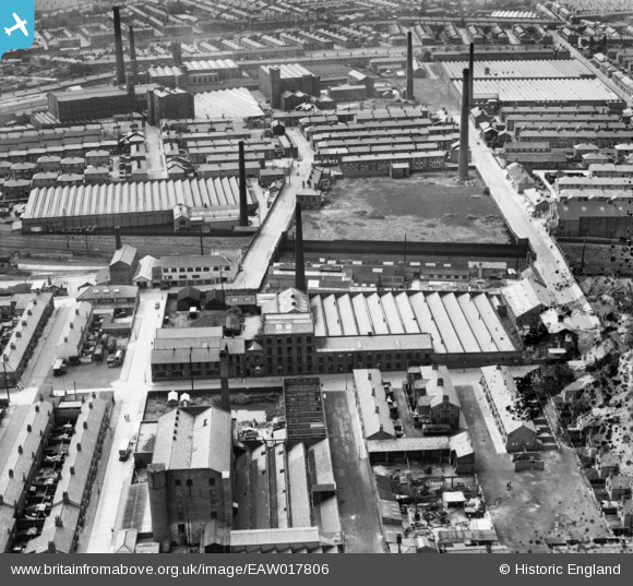
EAW017806 ENGLAND (1948). Queen's Cotton Mill, Preston, 1948. This image has been produced from a damaged negative.
© Copyright OpenStreetMap contributors and licensed by the OpenStreetMap Foundation. 2026. Cartography is licensed as CC BY-SA.
Nearby Images (7)
Details
| Title | [EAW017806] Queen's Cotton Mill, Preston, 1948. This image has been produced from a damaged negative. |
| Reference | EAW017806 |
| Date | 28-July-1948 |
| Link | |
| Place name | PRESTON |
| Parish | |
| District | |
| Country | ENGLAND |
| Easting / Northing | 352873, 430617 |
| Longitude / Latitude | -2.7150836063307, 53.769543678314 |
| National Grid Reference | SD529306 |
Pins

Class31 |
Monday 14th of September 2015 07:57:58 PM | |

Class31 |
Monday 14th of September 2015 07:57:40 PM | |

Class31 |
Monday 14th of September 2015 07:57:11 PM | |

Class31 |
Monday 14th of September 2015 07:56:26 PM | |

Class31 |
Monday 14th of September 2015 07:55:55 PM |
User Comment Contributions
We are looking west. |

Class31 |
Monday 14th of September 2015 07:58:16 PM |


![[EAW017806] Queen's Cotton Mill, Preston, 1948. This image has been produced from a damaged negative.](http://britainfromabove.org.uk/sites/all/libraries/aerofilms-images/public/100x100/EAW/017/EAW017806.jpg)
![[EAW017808] Queen's Cotton Mill, Preston, 1948](http://britainfromabove.org.uk/sites/all/libraries/aerofilms-images/public/100x100/EAW/017/EAW017808.jpg)
![[EAW017810] Queen's Cotton Mill, Preston, 1948](http://britainfromabove.org.uk/sites/all/libraries/aerofilms-images/public/100x100/EAW/017/EAW017810.jpg)
![[EAW017811] Queen's Cotton Mill, Preston, 1948](http://britainfromabove.org.uk/sites/all/libraries/aerofilms-images/public/100x100/EAW/017/EAW017811.jpg)
![[EAW017807] Queen's Cotton Mill, Preston, 1948. This image has been produced from a damaged negative.](http://britainfromabove.org.uk/sites/all/libraries/aerofilms-images/public/100x100/EAW/017/EAW017807.jpg)
![[EAW017809] Queen's Cotton Mill, Preston, 1948](http://britainfromabove.org.uk/sites/all/libraries/aerofilms-images/public/100x100/EAW/017/EAW017809.jpg)
![[EPW055139] The residential area surrounding Ripon Street, Eldon Street and Addison Road, Preston, 1937. This image has been produced from a copy-negative.](http://britainfromabove.org.uk/sites/all/libraries/aerofilms-images/public/100x100/EPW/055/EPW055139.jpg)