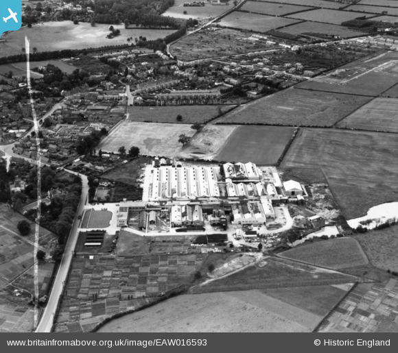
EAW016593 ENGLAND (1948). The British Timken Ltd Works, Duston, 1948. This image has been produced from a print marked by Aerofilms Ltd for photo editing.
© Copyright OpenStreetMap contributors and licensed by the OpenStreetMap Foundation. 2026. Cartography is licensed as CC BY-SA.
Nearby Images (9)
Details
| Title | [EAW016593] The British Timken Ltd Works, Duston, 1948. This image has been produced from a print marked by Aerofilms Ltd for photo editing. |
| Reference | EAW016593 |
| Date | 16-June-1948 |
| Link | |
| Place name | DUSTON |
| Parish | DUSTON |
| District | |
| Country | ENGLAND |
| Easting / Northing | 472474, 261250 |
| Longitude / Latitude | -0.93840133592874, 52.244259186462 |
| National Grid Reference | SP725613 |
Pins
Be the first to add a comment to this image!


![[EAW016593] The British Timken Ltd Works, Duston, 1948. This image has been produced from a print marked by Aerofilms Ltd for photo editing.](http://britainfromabove.org.uk/sites/all/libraries/aerofilms-images/public/100x100/EAW/016/EAW016593.jpg)
![[EAW014869] The British Timken Ltd shadow factory (roller bearings) on Main Road, Duston, from the south-west, 1948. This image has been produced from a print marked by Aerofilms Ltd for photo editing.](http://britainfromabove.org.uk/sites/all/libraries/aerofilms-images/public/100x100/EAW/014/EAW014869.jpg)
![[EAW016594] The British Timken Ltd Works, Duston, 1948. This image has been produced from a print marked by Aerofilms Ltd for photo editing.](http://britainfromabove.org.uk/sites/all/libraries/aerofilms-images/public/100x100/EAW/016/EAW016594.jpg)
![[EAW016596] The British Timken Ltd Works, Duston, 1948. This image has been produced from a print marked by Aerofilms Ltd for photo editing.](http://britainfromabove.org.uk/sites/all/libraries/aerofilms-images/public/100x100/EAW/016/EAW016596.jpg)
![[EAW016590] The British Timken Ltd shadow factory (roller bearings) on Main Road, Duston, 1948. This image was marked by Aerofilms Ltd for photo editing.](http://britainfromabove.org.uk/sites/all/libraries/aerofilms-images/public/100x100/EAW/016/EAW016590.jpg)
![[EAW016591] The British Timken Ltd shadow factory (roller bearings) on Main Road and environs, Duston, 1948. This image was marked by Aerofilms Ltd for photo editing.](http://britainfromabove.org.uk/sites/all/libraries/aerofilms-images/public/100x100/EAW/016/EAW016591.jpg)
![[EAW014877] The British Timken Ltd shadow factory (roller bearings) on Main Road, Duston, 1948. This image has been produced from a print.](http://britainfromabove.org.uk/sites/all/libraries/aerofilms-images/public/100x100/EAW/014/EAW014877.jpg)
![[EAW014870] The British Timken Ltd shadow factory (roller bearings) on Main Road, Duston, from the south, 1948. This image has been produced from a print marked by Aerofilms Ltd for photo editing.](http://britainfromabove.org.uk/sites/all/libraries/aerofilms-images/public/100x100/EAW/014/EAW014870.jpg)
![[EAW016595] The British Timken Ltd Works, Duston, 1948. This image has been produced from a print marked by Aerofilms Ltd for photo editing.](http://britainfromabove.org.uk/sites/all/libraries/aerofilms-images/public/100x100/EAW/016/EAW016595.jpg)