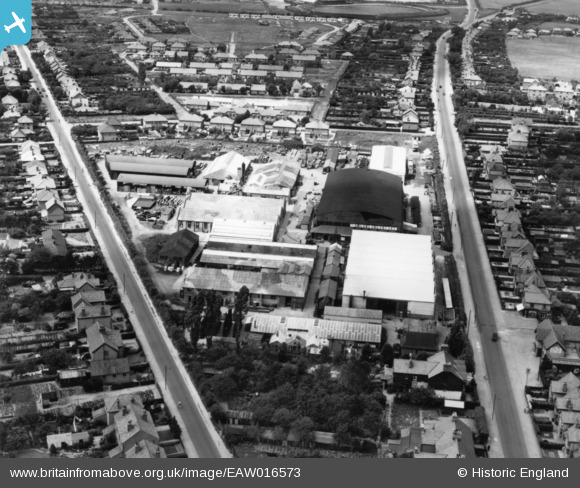
EAW016573 ENGLAND (1948). Mann Egerton Cromer Road Works, Hellesdon, 1948. This image has been produced from a print.
© Copyright OpenStreetMap contributors and licensed by the OpenStreetMap Foundation. 2026. Cartography is licensed as CC BY-SA.
Nearby Images (12)
Details
| Title | [EAW016573] Mann Egerton Cromer Road Works, Hellesdon, 1948. This image has been produced from a print. |
| Reference | EAW016573 |
| Date | 14-June-1948 |
| Link | |
| Place name | HELLESDON |
| Parish | HELLESDON |
| District | |
| Country | ENGLAND |
| Easting / Northing | 621597, 311781 |
| Longitude / Latitude | 1.2769392964651, 52.658040122554 |
| National Grid Reference | TG216118 |
Pins

Matt Aldred edob.mattaldred.com |
Wednesday 16th of March 2022 07:52:05 PM | |

Matt Aldred edob.mattaldred.com |
Wednesday 16th of March 2022 07:51:35 PM | |

Chris Kolonko |
Saturday 16th of September 2017 05:46:45 PM | |

Chris Kolonko |
Saturday 16th of September 2017 05:46:35 PM |


![[EAW016573] Mann Egerton Cromer Road Works, Hellesdon, 1948. This image has been produced from a print.](http://britainfromabove.org.uk/sites/all/libraries/aerofilms-images/public/100x100/EAW/016/EAW016573.jpg)
![[EAW016579] Mann Egerton Cromer Road Works, Hellesdon, 1948. This image has been produced from a damaged negative.](http://britainfromabove.org.uk/sites/all/libraries/aerofilms-images/public/100x100/EAW/016/EAW016579.jpg)
![[EAW016577] Mann Egerton Cromer Road Works (site of), Hellesdon, 1948. This image has been produced from a damaged negative.](http://britainfromabove.org.uk/sites/all/libraries/aerofilms-images/public/100x100/EAW/016/EAW016577.jpg)
![[EAW016574] Mann Egerton Cromer Road Works, Hellesdon, 1948. This image has been produced from a print.](http://britainfromabove.org.uk/sites/all/libraries/aerofilms-images/public/100x100/EAW/016/EAW016574.jpg)
![[EAW016570] Mann Egerton Cromer Road Works, Hellesdon, 1948. This image has been produced from a print.](http://britainfromabove.org.uk/sites/all/libraries/aerofilms-images/public/100x100/EAW/016/EAW016570.jpg)
![[EAW016571] Mann Egerton Cromer Road Works, Hellesdon, 1948. This image has been produced from a print.](http://britainfromabove.org.uk/sites/all/libraries/aerofilms-images/public/100x100/EAW/016/EAW016571.jpg)
![[EAW016572] Mann Egerton Cromer Road Works, Hellesdon, 1948. This image has been produced from a print.](http://britainfromabove.org.uk/sites/all/libraries/aerofilms-images/public/100x100/EAW/016/EAW016572.jpg)
![[EAW016576] Mann Egerton Cromer Road Works and environs, Hellesdon, 1948. This image has been produced from a print.](http://britainfromabove.org.uk/sites/all/libraries/aerofilms-images/public/100x100/EAW/016/EAW016576.jpg)
![[EAW016580] Mann Egerton Cromer Road Works, Hellesdon, 1948](http://britainfromabove.org.uk/sites/all/libraries/aerofilms-images/public/100x100/EAW/016/EAW016580.jpg)
![[EAW016578] Mann Egerton Cromer Road Works, Hellesdon, 1948. This image has been produced from a damaged negative.](http://britainfromabove.org.uk/sites/all/libraries/aerofilms-images/public/100x100/EAW/016/EAW016578.jpg)
![[EAW016581] Mann Egerton Cromer Road Works, Hellesdon, 1948](http://britainfromabove.org.uk/sites/all/libraries/aerofilms-images/public/100x100/EAW/016/EAW016581.jpg)
![[EAW016575] Mann Egerton Cromer Road Works, Hellesdon, 1948. This image has been produced from a print.](http://britainfromabove.org.uk/sites/all/libraries/aerofilms-images/public/100x100/EAW/016/EAW016575.jpg)