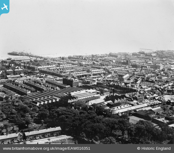
EAW016351 ENGLAND (1948). The Grout and Co Ltd Textile Factory and environs, Great Yarmouth, from the north-west, 1948. This image has been produced from a print.
© Copyright OpenStreetMap contributors and licensed by the OpenStreetMap Foundation. 2026. Cartography is licensed as CC BY-SA.
Nearby Images (29)
Details
| Title | [EAW016351] The Grout and Co Ltd Textile Factory and environs, Great Yarmouth, from the north-west, 1948. This image has been produced from a print. |
| Reference | EAW016351 |
| Date | 8-June-1948 |
| Link | |
| Place name | GREAT YARMOUTH |
| Parish | |
| District | |
| Country | ENGLAND |
| Easting / Northing | 652606, 308043 |
| Longitude / Latitude | 1.7316423044738, 52.610951603572 |
| National Grid Reference | TG526080 |


![[EAW016351] The Grout and Co Ltd Textile Factory and environs, Great Yarmouth, from the north-west, 1948. This image has been produced from a print.](http://britainfromabove.org.uk/sites/all/libraries/aerofilms-images/public/100x100/EAW/016/EAW016351.jpg)
![[EAW016346] The Grout and Co Ltd Textile Factory and environs, Great Yarmouth, from the north-west, 1948. This image has been produced from a print.](http://britainfromabove.org.uk/sites/all/libraries/aerofilms-images/public/100x100/EAW/016/EAW016346.jpg)
![[EAW052969] The Grout and Co Ltd Textile Factory on St Nicholas Road, Great Yarmouth, 1953. This image was marked by Aerofilms Ltd for photo editing.](http://britainfromabove.org.uk/sites/all/libraries/aerofilms-images/public/100x100/EAW/052/EAW052969.jpg)
![[EAW052967] The Grout and Co Ltd Textile Factory on St Nicholas Road, Great Yarmouth, 1953. This image was marked by Aerofilms Ltd for photo editing.](http://britainfromabove.org.uk/sites/all/libraries/aerofilms-images/public/100x100/EAW/052/EAW052967.jpg)
![[EAW016342] The Grout and Co Ltd Textile Factory and environs, Great Yarmouth, from the north-west, 1948. This image has been produced from a print.](http://britainfromabove.org.uk/sites/all/libraries/aerofilms-images/public/100x100/EAW/016/EAW016342.jpg)
![[EAW052968] The Grout and Co Ltd Textile Factory on St Nicholas Road, Great Yarmouth, 1953. This image was marked by Aerofilms Ltd for photo editing.](http://britainfromabove.org.uk/sites/all/libraries/aerofilms-images/public/100x100/EAW/052/EAW052968.jpg)
![[EAW052970] The Grout and Co Ltd Textile Factory and environs, Great Yarmouth, 1953. This image was marked by Aerofilms Ltd for photo editing.](http://britainfromabove.org.uk/sites/all/libraries/aerofilms-images/public/100x100/EAW/052/EAW052970.jpg)
![[EAW016345] The Grout and Co Ltd Textile Factory and environs, Great Yarmouth, from the west, 1948. This image has been produced from a print.](http://britainfromabove.org.uk/sites/all/libraries/aerofilms-images/public/100x100/EAW/016/EAW016345.jpg)
![[EAW052965] The Grout and Co Ltd Textile Factory on St Nicholas Road, Great Yarmouth, 1953. This image was marked by Aerofilms Ltd for photo editing.](http://britainfromabove.org.uk/sites/all/libraries/aerofilms-images/public/100x100/EAW/052/EAW052965.jpg)
![[EAW016353] The Grout and Co Ltd Textile Factory, Great Yarmouth, from the west, 1948. This image has been produced from a print.](http://britainfromabove.org.uk/sites/all/libraries/aerofilms-images/public/100x100/EAW/016/EAW016353.jpg)
![[EAW016348] The Grout and Co Ltd Textile Factory, Great Yarmouth, from the west, 1948. This image has been produced from a print.](http://britainfromabove.org.uk/sites/all/libraries/aerofilms-images/public/100x100/EAW/016/EAW016348.jpg)
![[EAW052966] The Grout and Co Ltd Textile Factory on St Nicholas Road, Great Yarmouth, 1953. This image was marked by Aerofilms Ltd for photo editing.](http://britainfromabove.org.uk/sites/all/libraries/aerofilms-images/public/100x100/EAW/052/EAW052966.jpg)
![[EAW016352] The Grout and Co Ltd Textile Factory, Great Yarmouth, from the west, 1948. This image has been produced from a print.](http://britainfromabove.org.uk/sites/all/libraries/aerofilms-images/public/100x100/EAW/016/EAW016352.jpg)
![[EAW052964] The Grout and Co Ltd Textile Factory on St Nicholas Road, Great Yarmouth, 1953. This image was marked by Aerofilms Ltd for photo editing.](http://britainfromabove.org.uk/sites/all/libraries/aerofilms-images/public/100x100/EAW/052/EAW052964.jpg)
![[EAW016343] The Grout and Co Ltd Textile Factory and environs, Great Yarmouth, 1948. This image has been produced from a print.](http://britainfromabove.org.uk/sites/all/libraries/aerofilms-images/public/100x100/EAW/016/EAW016343.jpg)
![[EAW016349] The Grout and Co Ltd Textile Factory and environs, Great Yarmouth, from the west, 1948. This image has been produced from a print.](http://britainfromabove.org.uk/sites/all/libraries/aerofilms-images/public/100x100/EAW/016/EAW016349.jpg)
![[EPW008057] Grout's Silk Factory, Great Yarmouth, 1922](http://britainfromabove.org.uk/sites/all/libraries/aerofilms-images/public/100x100/EPW/008/EPW008057.jpg)
![[EPW008058] Grout's Silk Factory, Great Yarmouth, 1922](http://britainfromabove.org.uk/sites/all/libraries/aerofilms-images/public/100x100/EPW/008/EPW008058.jpg)
![[EAW016347] The Grout and Co Ltd Textile Factory and environs, Great Yarmouth, from the north-west, 1948. This image has been produced from a print.](http://britainfromabove.org.uk/sites/all/libraries/aerofilms-images/public/100x100/EAW/016/EAW016347.jpg)
![[EAW052963] The Grout and Co Ltd Textile Factory on St Nicholas Road, Great Yarmouth, 1953. This image was marked by Aerofilms Ltd for photo editing.](http://britainfromabove.org.uk/sites/all/libraries/aerofilms-images/public/100x100/EAW/052/EAW052963.jpg)
![[EAW052971] The Grout and Co Ltd Textile Factory on St Nicholas Road, Great Yarmouth, 1953. This image was marked by Aerofilms Ltd for photo editing.](http://britainfromabove.org.uk/sites/all/libraries/aerofilms-images/public/100x100/EAW/052/EAW052971.jpg)
![[EPW008055] Grout's Silk Factory, Great Yarmouth, 1922](http://britainfromabove.org.uk/sites/all/libraries/aerofilms-images/public/100x100/EPW/008/EPW008055.jpg)
![[EPW008056] Grout's Silk Factory, Great Yarmouth, 1922](http://britainfromabove.org.uk/sites/all/libraries/aerofilms-images/public/100x100/EPW/008/EPW008056.jpg)
![[EPW008059] Grout's Silk Factory, Great Yarmouth, 1922](http://britainfromabove.org.uk/sites/all/libraries/aerofilms-images/public/100x100/EPW/008/EPW008059.jpg)
![[EPW021188] The Grout and Company Silk Crape Factory, Beach Railway Station and the Church of St Nicholas, Great Yarmouth, 1928](http://britainfromabove.org.uk/sites/all/libraries/aerofilms-images/public/100x100/EPW/021/EPW021188.jpg)
![[EAW016350] The Grout and Co Ltd Textile Factory and environs, Great Yarmouth, from the north-east, 1948. This image has been produced from a print.](http://britainfromabove.org.uk/sites/all/libraries/aerofilms-images/public/100x100/EAW/016/EAW016350.jpg)
![[EAW052973] The ruins of St Nicholas's Church, Great Yarmouth, 1953](http://britainfromabove.org.uk/sites/all/libraries/aerofilms-images/public/100x100/EAW/052/EAW052973.jpg)
![[EAW016344] The Grout and Co Ltd Textile Factory and environs, Great Yarmouth, from the east, 1948. This image has been produced from a print.](http://britainfromabove.org.uk/sites/all/libraries/aerofilms-images/public/100x100/EAW/016/EAW016344.jpg)
![[EAW016380] The Grout and Co Ltd Textile Factory and environs, Great Yarmouth, from the east, 1948. This image has been produced from a print.](http://britainfromabove.org.uk/sites/all/libraries/aerofilms-images/public/100x100/EAW/016/EAW016380.jpg)
