
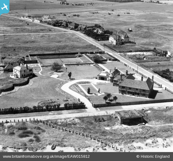
EAW015812 ENGLAND (1948). Kentlands and King's Road, Sandwich Bay Estate, 1948. This image has been produced from a print.
© Copyright OpenStreetMap contributors and licensed by the OpenStreetMap Foundation. 2026. Cartography is licensed as CC BY-SA.
Nearby Images (4)
EAW015812

EAW015811

EAW015813

EAW015810

Details
| Title | [EAW015812] Kentlands and King's Road, Sandwich Bay Estate, 1948. This image has been produced from a print. |
| Reference | EAW015812 |
| Date | 19-May-1948 |
| Link | |
| Place name | SANDWICH BAY ESTATE |
| Parish | WORTH |
| District | |
| Country | ENGLAND |
| Easting / Northing | 636293, 157657 |
| Longitude / Latitude | 1.3877929687532, 51.268484489378 |
| National Grid Reference | TR363577 |
Pins

Matt Aldred edob.mattaldred.com |
Sunday 29th of November 2020 09:29:47 PM | |
|
Matt Aldred edob.mattaldred.com |
Sunday 29th of November 2020 09:29:23 PM | |

Sparky |
Monday 3rd of July 2017 11:14:53 PM | |
|
Sparky |
Monday 3rd of July 2017 11:13:01 PM | |
|
Sparky |
Monday 3rd of July 2017 11:10:24 PM | |
|
Sparky |
Monday 3rd of July 2017 11:09:21 PM | |
|
Sparky |
Monday 3rd of July 2017 11:08:02 PM | |
|
Sparky |
Monday 3rd of July 2017 11:06:09 PM | |
|
Sparky |
Monday 3rd of July 2017 11:04:09 PM | |
|
Sparky |
Monday 3rd of July 2017 11:02:47 PM | |

cptpies |
Wednesday 8th of April 2015 11:25:28 AM | |
|
cptpies |
Wednesday 8th of April 2015 11:23:48 AM |
User Comment Contributions

Clear view of obstacles and Artillery gun house at Sandwich Bay Estate. |
cptpies |
Wednesday 8th of April 2015 11:26:44 AM |