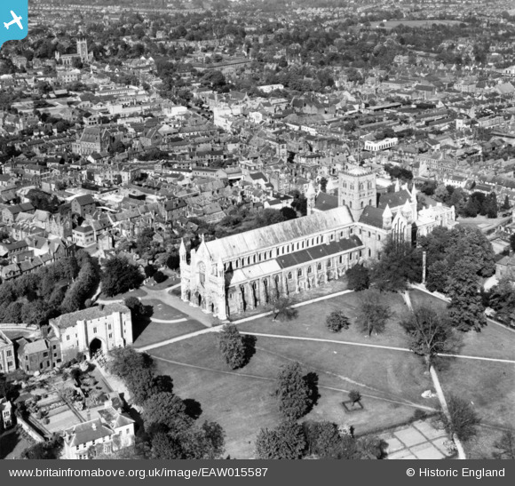
EAW015587 ENGLAND (1948). St Albans Cathedral and the city, St Albans, 1948. This image has been produced from a print.
© Copyright OpenStreetMap contributors and licensed by the OpenStreetMap Foundation. 2026. Cartography is licensed as CC BY-SA.
Nearby Images (48)
Details
| Title | [EAW015587] St Albans Cathedral and the city, St Albans, 1948. This image has been produced from a print. |
| Reference | EAW015587 |
| Date | 13-May-1948 |
| Link | |
| Place name | ST ALBANS |
| Parish | |
| District | |
| Country | ENGLAND |
| Easting / Northing | 514505, 207074 |
| Longitude / Latitude | -0.34106371588407, 51.750188827418 |
| National Grid Reference | TL145071 |
Pins
Be the first to add a comment to this image!


![[EAW015587] St Albans Cathedral and the city, St Albans, 1948. This image has been produced from a print.](http://britainfromabove.org.uk/sites/all/libraries/aerofilms-images/public/100x100/EAW/015/EAW015587.jpg)
![[EPW025394] St Albans Cathedral and the town, St Albans, 1928](http://britainfromabove.org.uk/sites/all/libraries/aerofilms-images/public/100x100/EPW/025/EPW025394.jpg)
![[EPW019239] St Alban's Cathedral, St Albans, 1927](http://britainfromabove.org.uk/sites/all/libraries/aerofilms-images/public/100x100/EPW/019/EPW019239.jpg)
![[EAW015583] St Albans Cathedral, St Albans, 1948](http://britainfromabove.org.uk/sites/all/libraries/aerofilms-images/public/100x100/EAW/015/EAW015583.jpg)
![[EPW019242] St Alban's Cathedral, St Albans, 1927](http://britainfromabove.org.uk/sites/all/libraries/aerofilms-images/public/100x100/EPW/019/EPW019242.jpg)
![[EAW015584] St Albans Cathedral, St Albans, 1948](http://britainfromabove.org.uk/sites/all/libraries/aerofilms-images/public/100x100/EAW/015/EAW015584.jpg)
![[EAW015586] St Albans Cathedral and the city, St Albans, from the south-west, 1948. This image has been produced from a damaged negative.](http://britainfromabove.org.uk/sites/all/libraries/aerofilms-images/public/100x100/EAW/015/EAW015586.jpg)
![[EPW005304] St Albans Cathedral, St Albans, 1921](http://britainfromabove.org.uk/sites/all/libraries/aerofilms-images/public/100x100/EPW/005/EPW005304.jpg)
![[EAW027917] St Albans Cathedral and the city centre, St Albans, from the south-west, 1950](http://britainfromabove.org.uk/sites/all/libraries/aerofilms-images/public/100x100/EAW/027/EAW027917.jpg)
![[EPW047111] St Albans Cathedral, Abbey Gate and the city centre, St Albans, 1935](http://britainfromabove.org.uk/sites/all/libraries/aerofilms-images/public/100x100/EPW/047/EPW047111.jpg)
![[EAW011299] St Alban's Cathedral and the city, St Albans, from the south-west, 1947](http://britainfromabove.org.uk/sites/all/libraries/aerofilms-images/public/100x100/EAW/011/EAW011299.jpg)
![[EPW001258] St Albans Cathedral and Abbey, St Albans, 1920](http://britainfromabove.org.uk/sites/all/libraries/aerofilms-images/public/100x100/EPW/001/EPW001258.jpg)
![[EAW015585] St Albans Cathedral and the city, St Albans, from the west, 1948. This image has been produced from a print.](http://britainfromabove.org.uk/sites/all/libraries/aerofilms-images/public/100x100/EAW/015/EAW015585.jpg)
![[EPW047109] St Albans Cathedral, Abbey Gate and the city centre, St Albans, 1935](http://britainfromabove.org.uk/sites/all/libraries/aerofilms-images/public/100x100/EPW/047/EPW047109.jpg)
![[EPW017813] St Alban's Cathedral, St Albans, 1927](http://britainfromabove.org.uk/sites/all/libraries/aerofilms-images/public/100x100/EPW/017/EPW017813.jpg)
![[EPW001255] St Albans Cathedral and Abbey, St Albans, 1920](http://britainfromabove.org.uk/sites/all/libraries/aerofilms-images/public/100x100/EPW/001/EPW001255.jpg)
![[EPW017812] St Alban's Cathedral, St Albans, 1927](http://britainfromabove.org.uk/sites/all/libraries/aerofilms-images/public/100x100/EPW/017/EPW017812.jpg)
![[EPW047105] St Albans Cathedral and the city centre, St Albans, 1935](http://britainfromabove.org.uk/sites/all/libraries/aerofilms-images/public/100x100/EPW/047/EPW047105.jpg)
![[EPW047112] St Albans Cathedral, Abbey Gate and the city centre, St Albans, 1935](http://britainfromabove.org.uk/sites/all/libraries/aerofilms-images/public/100x100/EPW/047/EPW047112.jpg)
![[EPW047106] St Albans Cathedral and the city centre, St Albans, 1935](http://britainfromabove.org.uk/sites/all/libraries/aerofilms-images/public/100x100/EPW/047/EPW047106.jpg)
![[EAW048027] St Albans Cathedral, the Market Place and environs, St Albans, 1952](http://britainfromabove.org.uk/sites/all/libraries/aerofilms-images/public/100x100/EAW/048/EAW048027.jpg)
![[EPW019241] St Alban's Cathedral, St Albans, 1927](http://britainfromabove.org.uk/sites/all/libraries/aerofilms-images/public/100x100/EPW/019/EPW019241.jpg)
![[EPW047107] St Albans Cathedral, Abbey Gate and the city centre, St Albans, 1935](http://britainfromabove.org.uk/sites/all/libraries/aerofilms-images/public/100x100/EPW/047/EPW047107.jpg)
![[EPW001251] St Albans Cathedral and Abbey, St Albans, 1920](http://britainfromabove.org.uk/sites/all/libraries/aerofilms-images/public/100x100/EPW/001/EPW001251.jpg)
![[EAW011300] St Alban's Cathedral and the city, St Albans, from the south-west, 1947](http://britainfromabove.org.uk/sites/all/libraries/aerofilms-images/public/100x100/EAW/011/EAW011300.jpg)
![[EAW025079] St Albans School, the cathedral and environs, St Albans, 1949. This image has been produced from a print marked by Aerofilms Ltd for photo editing.](http://britainfromabove.org.uk/sites/all/libraries/aerofilms-images/public/100x100/EAW/025/EAW025079.jpg)
![[EPW047110] St Albans Cathedral, Holywell Hill and the city centre, St Albans, 1935](http://britainfromabove.org.uk/sites/all/libraries/aerofilms-images/public/100x100/EPW/047/EPW047110.jpg)
![[EPW001253] View of St Albans and St Albans Cathedral and Abbey, St Albans, 1920](http://britainfromabove.org.uk/sites/all/libraries/aerofilms-images/public/100x100/EPW/001/EPW001253.jpg)
![[EPW017814] St Alban's Cathedral, St Albans, 1927](http://britainfromabove.org.uk/sites/all/libraries/aerofilms-images/public/100x100/EPW/017/EPW017814.jpg)
![[EPW005305] Romeland Hill, St Albans, 1921](http://britainfromabove.org.uk/sites/all/libraries/aerofilms-images/public/100x100/EPW/005/EPW005305.jpg)
![[EAW048025] St Albans Cathedral, St Albans, 1952](http://britainfromabove.org.uk/sites/all/libraries/aerofilms-images/public/100x100/EAW/048/EAW048025.jpg)
![[EAW025078] St Albans School and the city, St Albans, 1949. This image has been produced from a print marked by Aerofilms Ltd for photo editing.](http://britainfromabove.org.uk/sites/all/libraries/aerofilms-images/public/100x100/EAW/025/EAW025078.jpg)
![[EAW025084] St Albans School, St Albans, 1949. This image has been produced from a print.](http://britainfromabove.org.uk/sites/all/libraries/aerofilms-images/public/100x100/EAW/025/EAW025084.jpg)
![[EAW015583A] St Albans Cathedral and the city, St Albans, 1948](http://britainfromabove.org.uk/sites/all/libraries/aerofilms-images/public/100x100/EAW/015/EAW015583A.jpg)
![[EPW047108] St Albans Cathedral and the city centre, St Albans, 1935](http://britainfromabove.org.uk/sites/all/libraries/aerofilms-images/public/100x100/EPW/047/EPW047108.jpg)
![[EAW030954] The Cathedral and Abbey Church of Saint Alban, the Gas Works and the city centre, St Albans, from the north-east, 1950](http://britainfromabove.org.uk/sites/all/libraries/aerofilms-images/public/100x100/EAW/030/EAW030954.jpg)
![[EAW027918] St Albans Cathedral and the city centre, St Albans, from the south, 1950](http://britainfromabove.org.uk/sites/all/libraries/aerofilms-images/public/100x100/EAW/027/EAW027918.jpg)
![[EAW025077] St Albans School and environs, St Albans, from the south-east, 1949. This image has been produced from a print marked by Aerofilms Ltd for photo editing.](http://britainfromabove.org.uk/sites/all/libraries/aerofilms-images/public/100x100/EAW/025/EAW025077.jpg)
![[EAW048026] St Albans Cathedral and environs, St Albans, 1952](http://britainfromabove.org.uk/sites/all/libraries/aerofilms-images/public/100x100/EAW/048/EAW048026.jpg)
![[EPW001568] St Alban's Cathedral and the town centre, St Alban's, 1920](http://britainfromabove.org.uk/sites/all/libraries/aerofilms-images/public/100x100/EPW/001/EPW001568.jpg)
![[EPW001250] St Albans Cathedral and Abbey, St Albans, 1920](http://britainfromabove.org.uk/sites/all/libraries/aerofilms-images/public/100x100/EPW/001/EPW001250.jpg)
![[EAW025080] St Albans School, St Albans, 1949. This image has been produced from a print marked by Aerofilms Ltd for photo editing.](http://britainfromabove.org.uk/sites/all/libraries/aerofilms-images/public/100x100/EAW/025/EAW025080.jpg)
![[EAW025083] St Albans School and the city, St Albans, 1949. This image has been produced from a print marked by Aerofilms Ltd for photo editing.](http://britainfromabove.org.uk/sites/all/libraries/aerofilms-images/public/100x100/EAW/025/EAW025083.jpg)
![[EAW000662] St Alban's Cathedral and the city, St Albans, from the south, 1946](http://britainfromabove.org.uk/sites/all/libraries/aerofilms-images/public/100x100/EAW/000/EAW000662.jpg)
![[EPW001567] St Alban's Cathedral and the town centre, St Alban's, from the south-west, 1920](http://britainfromabove.org.uk/sites/all/libraries/aerofilms-images/public/100x100/EPW/001/EPW001567.jpg)
![[EAW025082] St Albans School, St Albans, 1949. This image has been produced from a print marked by Aerofilms Ltd for photo editing.](http://britainfromabove.org.uk/sites/all/libraries/aerofilms-images/public/100x100/EAW/025/EAW025082.jpg)
![[EAW015569] The Clock Tower and the city centre, St Albans, 1948](http://britainfromabove.org.uk/sites/all/libraries/aerofilms-images/public/100x100/EAW/015/EAW015569.jpg)
![[EAW025081] St Albans School, St Albans, 1949. This image has been produced from a print marked by Aerofilms Ltd for photo editing.](http://britainfromabove.org.uk/sites/all/libraries/aerofilms-images/public/100x100/EAW/025/EAW025081.jpg)