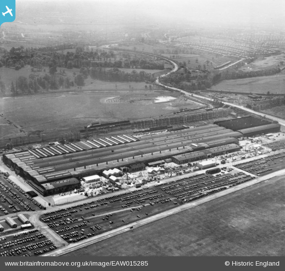
EAW015285 ENGLAND (1948). The British Industries Fair Exhibition Centre, Castle Vale, from the north, 1948. This image has been produced from a print.
© Copyright OpenStreetMap contributors and licensed by the OpenStreetMap Foundation. 2026. Cartography is licensed as CC BY-SA.
Nearby Images (19)
Details
| Title | [EAW015285] The British Industries Fair Exhibition Centre, Castle Vale, from the north, 1948. This image has been produced from a print. |
| Reference | EAW015285 |
| Date | 7-May-1948 |
| Link | |
| Place name | CASTLE VALE |
| Parish | |
| District | |
| Country | ENGLAND |
| Easting / Northing | 414224, 290783 |
| Longitude / Latitude | -1.7903745241441, 52.514382597168 |
| National Grid Reference | SP142908 |
Pins
Be the first to add a comment to this image!


![[EAW015285] The British Industries Fair Exhibition Centre, Castle Vale, from the north, 1948. This image has been produced from a print.](http://britainfromabove.org.uk/sites/all/libraries/aerofilms-images/public/100x100/EAW/015/EAW015285.jpg)
![[EAW015282] The British Industries Fair Exhibition Centre, Castle Vale, from the north, 1948. This image has been produced from a print.](http://britainfromabove.org.uk/sites/all/libraries/aerofilms-images/public/100x100/EAW/015/EAW015282.jpg)
![[EAW015281] The British Industries Fair Exhibition Centre, Castle Vale, from the north-west, 1948. This image has been produced from a print.](http://britainfromabove.org.uk/sites/all/libraries/aerofilms-images/public/100x100/EAW/015/EAW015281.jpg)
![[EPW054850] The British Industries Fair Exhibition Hall, Castle Vale, 1937](http://britainfromabove.org.uk/sites/all/libraries/aerofilms-images/public/100x100/EPW/054/EPW054850.jpg)
![[EAW014404] The British Industries Fair Exhibition Hall, Castle Vale, 1948. This image has been produced from a print.](http://britainfromabove.org.uk/sites/all/libraries/aerofilms-images/public/100x100/EAW/014/EAW014404.jpg)
![[EAW015276] The British Industries Fair Exhibition Centre, Castle Vale, from the north, 1948. This image has been produced from a print.](http://britainfromabove.org.uk/sites/all/libraries/aerofilms-images/public/100x100/EAW/015/EAW015276.jpg)
![[EAW015279] The British Industries Fair Exhibition Centre alongside Castle Bromwich Airfield, Castle Vale, from the south-east, 1948. This image has been produced from a print.](http://britainfromabove.org.uk/sites/all/libraries/aerofilms-images/public/100x100/EAW/015/EAW015279.jpg)
![[EAW014402] The British Industries Fair Exhibition Hall (site of), Castle Vale, 1948. This image has been produced from a damaged negative.](http://britainfromabove.org.uk/sites/all/libraries/aerofilms-images/public/100x100/EAW/014/EAW014402.jpg)
![[EPW042881] British Industries Fair Exhibition Hall, Castle Vale, 1933](http://britainfromabove.org.uk/sites/all/libraries/aerofilms-images/public/100x100/EPW/042/EPW042881.jpg)
![[EAW043036] The British Industries Fair Buildings, Castle Vale, 1952. This image has been produced from a damaged negative.](http://britainfromabove.org.uk/sites/all/libraries/aerofilms-images/public/100x100/EAW/043/EAW043036.jpg)
![[EPW042880] British Industries Fair Exhibition Hall and Castle Bromwich Station, Castle Vale, 1933](http://britainfromabove.org.uk/sites/all/libraries/aerofilms-images/public/100x100/EPW/042/EPW042880.jpg)
![[EAW015277] The British Industries Fair Exhibition Centre, Castle Vale, from the west, 1948. This image has been produced from a print.](http://britainfromabove.org.uk/sites/all/libraries/aerofilms-images/public/100x100/EAW/015/EAW015277.jpg)
![[EAW043039] The British Industries Fair Buildings, Castle Vale, 1952](http://britainfromabove.org.uk/sites/all/libraries/aerofilms-images/public/100x100/EAW/043/EAW043039.jpg)
![[EPW042879] British Industries Fair Exhibition Hall and Castle Bromwich Station, Castle Vale, 1933](http://britainfromabove.org.uk/sites/all/libraries/aerofilms-images/public/100x100/EPW/042/EPW042879.jpg)
![[EPW054851] The British Industries Fair Exhibition Hall, Castle Vale, 1937](http://britainfromabove.org.uk/sites/all/libraries/aerofilms-images/public/100x100/EPW/054/EPW054851.jpg)
![[EAW014403] The British Industries Fair Exhibition Hall, Castle Vale, 1948. This image has been produced from a print.](http://britainfromabove.org.uk/sites/all/libraries/aerofilms-images/public/100x100/EAW/014/EAW014403.jpg)
![[EAW015286] The British Industries Fair Exhibition Centre, Castle Vale, 1948. This image has been produced from a damaged print.](http://britainfromabove.org.uk/sites/all/libraries/aerofilms-images/public/100x100/EAW/015/EAW015286.jpg)
![[EAW014405] The British Industries Fair Exhibition Hall, Castle Vale, 1948. This image has been produced from a print.](http://britainfromabove.org.uk/sites/all/libraries/aerofilms-images/public/100x100/EAW/014/EAW014405.jpg)
![[EAW015278] The British Industries Fair Exhibition Centre, Castle Vale, from the south-west, 1948. This image has been produced from a print.](http://britainfromabove.org.uk/sites/all/libraries/aerofilms-images/public/100x100/EAW/015/EAW015278.jpg)