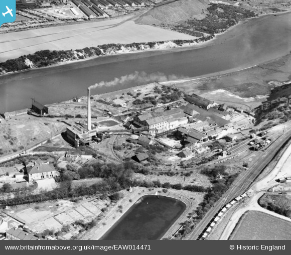
EAW014471 ENGLAND (1948). The Ford Paper Mill alongside the River Wear, South Hylton, 1948
© Copyright OpenStreetMap contributors and licensed by the OpenStreetMap Foundation. 2026. Cartography is licensed as CC BY-SA.
Nearby Images (13)
Details
| Title | [EAW014471] The Ford Paper Mill alongside the River Wear, South Hylton, 1948 |
| Reference | EAW014471 |
| Date | 15-April-1948 |
| Link | |
| Place name | SOUTH HYLTON |
| Parish | |
| District | |
| Country | ENGLAND |
| Easting / Northing | 435970, 557409 |
| Longitude / Latitude | -1.438889951087, 54.91001268498 |
| National Grid Reference | NZ360574 |


![[EAW014471] The Ford Paper Mill alongside the River Wear, South Hylton, 1948](http://britainfromabove.org.uk/sites/all/libraries/aerofilms-images/public/100x100/EAW/014/EAW014471.jpg)
![[EAW014469] The Ford Paper Mill alongside the River Wear, South Hylton, 1948](http://britainfromabove.org.uk/sites/all/libraries/aerofilms-images/public/100x100/EAW/014/EAW014469.jpg)
![[EAW014472] The Ford Paper Mill, South Hylton, 1948](http://britainfromabove.org.uk/sites/all/libraries/aerofilms-images/public/100x100/EAW/014/EAW014472.jpg)
![[EAW014476] The Ford Paper Mill, South Hylton, 1948](http://britainfromabove.org.uk/sites/all/libraries/aerofilms-images/public/100x100/EAW/014/EAW014476.jpg)
![[EAW014470] The Ford Paper Mill, South Hylton, 1948](http://britainfromabove.org.uk/sites/all/libraries/aerofilms-images/public/100x100/EAW/014/EAW014470.jpg)
![[EAW014475] The Ford Paper Mill and the Ford Limestone Quarry, South Hylton, 1948](http://britainfromabove.org.uk/sites/all/libraries/aerofilms-images/public/100x100/EAW/014/EAW014475.jpg)
![[EAW014477] The Ford Paper Mill, South Hylton, 1948](http://britainfromabove.org.uk/sites/all/libraries/aerofilms-images/public/100x100/EAW/014/EAW014477.jpg)
![[EAW014474] The Ford Paper Mill, South Hylton, 1948](http://britainfromabove.org.uk/sites/all/libraries/aerofilms-images/public/100x100/EAW/014/EAW014474.jpg)
![[EAW014479] The Ford Paper Mill and the Ford Limestone Quarry, South Hylton, 1948](http://britainfromabove.org.uk/sites/all/libraries/aerofilms-images/public/100x100/EAW/014/EAW014479.jpg)
![[EAW014478] The Ford Paper Mill, South Hylton, 1948](http://britainfromabove.org.uk/sites/all/libraries/aerofilms-images/public/100x100/EAW/014/EAW014478.jpg)
![[EPW016428] Ford Paper Mills, South Hylton, 1926](http://britainfromabove.org.uk/sites/all/libraries/aerofilms-images/public/100x100/EPW/016/EPW016428.jpg)
![[EAW014473] The Ford Paper Mill and the Ford Limestone Quarry, South Hylton, 1948](http://britainfromabove.org.uk/sites/all/libraries/aerofilms-images/public/100x100/EAW/014/EAW014473.jpg)
![[EPW016427] Ford Paper Mills, South Hylton, 1926](http://britainfromabove.org.uk/sites/all/libraries/aerofilms-images/public/100x100/EPW/016/EPW016427.jpg)
