
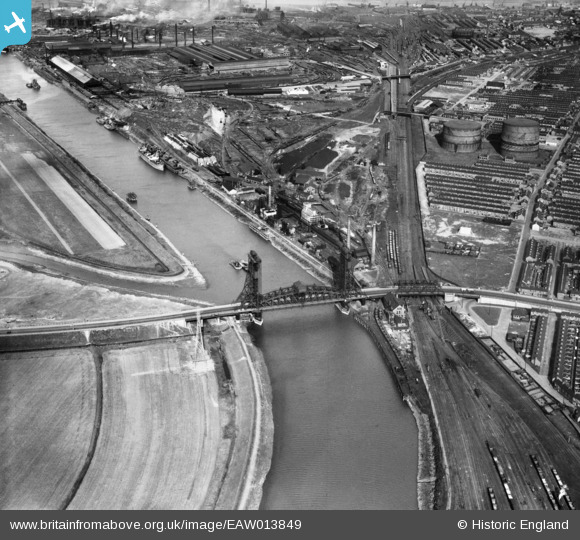
EAW013849 ENGLAND (1948). The Tees Newport Bridge and environs, Middlesbrough, 1948
© Copyright OpenStreetMap contributors and licensed by the OpenStreetMap Foundation. 2026. Cartography is licensed as CC BY-SA.
Nearby Images (6)
EAW013849

EAW024128
 Bridge, Middlesbrough, 1949")
EPW042126

EAW024130
 Bridge, Middlesbrough, 1949")
EAW024129
 Bridge, Middlesbrough, 1949")
EPW042125

Details
| Title | [EAW013849] The Tees Newport Bridge and environs, Middlesbrough, 1948 |
| Reference | EAW013849 |
| Date | 16-March-1948 |
| Link | |
| Place name | MIDDLESBROUGH |
| Parish | |
| District | |
| Country | ENGLAND |
| Easting / Northing | 447921, 519993 |
| Longitude / Latitude | -1.2586434315084, 54.57275727196 |
| National Grid Reference | NZ479200 |
Pins

redmist |
Monday 29th of November 2021 10:33:13 PM | |
|
redmist |
Monday 29th of November 2021 10:32:50 PM | |
|
redmist |
Monday 29th of November 2021 10:32:22 PM | |
|
John Owens |
Saturday 23rd of May 2020 09:31:15 PM | |
|
morbidthepoet |
Sunday 20th of May 2018 04:55:08 AM | |
|
J May |
Tuesday 11th of November 2014 02:56:46 PM | |
|
km |
Monday 16th of June 2014 09:14:45 PM | |
|
km |
Monday 16th of June 2014 09:14:04 PM | |
|
km |
Monday 16th of June 2014 09:13:21 PM | |
|
km |
Monday 16th of June 2014 09:12:45 PM | |
|
km |
Monday 16th of June 2014 09:11:16 PM | |
|
km |
Monday 16th of June 2014 09:08:47 PM | |
|
km |
Monday 16th of June 2014 09:07:42 PM | |
|
km |
Monday 16th of June 2014 08:46:57 PM | |
|
km |
Monday 16th of June 2014 08:45:18 PM | |
|
km |
Monday 16th of June 2014 08:44:25 PM |