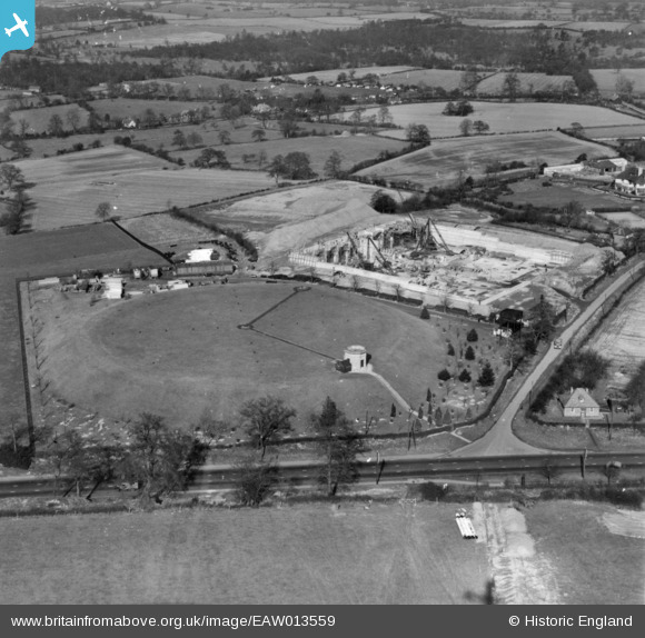
EAW013559 ENGLAND (1948). Two covered reservoirs (Coventry Corporation) under construction off Showell Lane, Meriden, 1948. This image has been produced from a print.
© Copyright OpenStreetMap contributors and licensed by the OpenStreetMap Foundation. 2026. Cartography is licensed as CC BY-SA.
Nearby Images (42)
Details
| Title | [EAW013559] Two covered reservoirs (Coventry Corporation) under construction off Showell Lane, Meriden, 1948. This image has been produced from a print. |
| Reference | EAW013559 |
| Date | 9-March-1948 |
| Link | |
| Place name | MERIDEN |
| Parish | MERIDEN |
| District | |
| Country | ENGLAND |
| Easting / Northing | 425823, 282058 |
| Longitude / Latitude | -1.6201141604853, 52.435511516544 |
| National Grid Reference | SP258821 |
Pins
Be the first to add a comment to this image!


![[EAW013559] Two covered reservoirs (Coventry Corporation) under construction off Showell Lane, Meriden, 1948. This image has been produced from a print.](http://britainfromabove.org.uk/sites/all/libraries/aerofilms-images/public/100x100/EAW/013/EAW013559.jpg)
![[EAW020664] Coventry Corporation Reservoir Number 2 under construction, Meriden, 1948](http://britainfromabove.org.uk/sites/all/libraries/aerofilms-images/public/100x100/EAW/020/EAW020664.jpg)
![[EAW020657] Coventry Corporation Reservoir Number 2 under construction, Meriden, 1948. This image was marked by Aerofilms Ltd for photo editing.](http://britainfromabove.org.uk/sites/all/libraries/aerofilms-images/public/100x100/EAW/020/EAW020657.jpg)
![[EAW017190] Reservoirs on Showell Lane, Meriden, 1948](http://britainfromabove.org.uk/sites/all/libraries/aerofilms-images/public/100x100/EAW/017/EAW017190.jpg)
![[EAW013553] Two covered reservoirs (Coventry Corporation) off Showell Lane, Meriden, 1948. This image has been produced from a print.](http://britainfromabove.org.uk/sites/all/libraries/aerofilms-images/public/100x100/EAW/013/EAW013553.jpg)
![[EAW013551] A covered reservoir under construction on Showell Lane, Meriden, 1948](http://britainfromabove.org.uk/sites/all/libraries/aerofilms-images/public/100x100/EAW/013/EAW013551.jpg)
![[EAW013552] A covered reservoir under construction on Showell Lane, Meriden, 1948](http://britainfromabove.org.uk/sites/all/libraries/aerofilms-images/public/100x100/EAW/013/EAW013552.jpg)
![[EPW035794] The Meriden Reservoir under construction, Meriden, 1931](http://britainfromabove.org.uk/sites/all/libraries/aerofilms-images/public/100x100/EPW/035/EPW035794.jpg)
![[EAW020658] Coventry Corporation Reservoir Number 2 under construction, Meriden, 1948](http://britainfromabove.org.uk/sites/all/libraries/aerofilms-images/public/100x100/EAW/020/EAW020658.jpg)
![[EAW017189] A covered reservoir under construction on Showell Lane, Meriden, 1948](http://britainfromabove.org.uk/sites/all/libraries/aerofilms-images/public/100x100/EAW/017/EAW017189.jpg)
![[EPW035792] The Meriden Reservoir under construction, Meriden, 1931](http://britainfromabove.org.uk/sites/all/libraries/aerofilms-images/public/100x100/EPW/035/EPW035792.jpg)
![[EPW035796] The Meriden Reservoir under construction, Meriden, 1931](http://britainfromabove.org.uk/sites/all/libraries/aerofilms-images/public/100x100/EPW/035/EPW035796.jpg)
![[EAW020652] Coventry Corporation Reservoir under construction, Meriden, 1948](http://britainfromabove.org.uk/sites/all/libraries/aerofilms-images/public/100x100/EAW/020/EAW020652.jpg)
![[EAW017193] A covered reservoir under construction on Showell Lane, Meriden, 1948. This image was marked by Aerodilms Ltd for photo editing.](http://britainfromabove.org.uk/sites/all/libraries/aerofilms-images/public/100x100/EAW/017/EAW017193.jpg)
![[EAW020654] Coventry Corporation Reservoir Number 2 under construction, Meriden, 1948](http://britainfromabove.org.uk/sites/all/libraries/aerofilms-images/public/100x100/EAW/020/EAW020654.jpg)
![[EAW020653] Coventry Corporation Reservoir Number 2 under construction, Meriden, 1948](http://britainfromabove.org.uk/sites/all/libraries/aerofilms-images/public/100x100/EAW/020/EAW020653.jpg)
![[EAW013556] A covered reservoir (Coventry Corporation) under construction off Showell Lane, Meriden, 1948. This image has been produced from a print.](http://britainfromabove.org.uk/sites/all/libraries/aerofilms-images/public/100x100/EAW/013/EAW013556.jpg)
![[EAW013557] A covered reservoir (Coventry Corporation) under construction off Showell Lane, Meriden, 1948. This image has been produced from a print.](http://britainfromabove.org.uk/sites/all/libraries/aerofilms-images/public/100x100/EAW/013/EAW013557.jpg)
![[EPW035793] The Meriden Reservoir under construction, Meriden, 1931](http://britainfromabove.org.uk/sites/all/libraries/aerofilms-images/public/100x100/EPW/035/EPW035793.jpg)
![[EAW017198] A covered reservoir under construction on Showell Lane, Meriden, 1948. This image was marked by Aerofilms Ltd for photo editing.](http://britainfromabove.org.uk/sites/all/libraries/aerofilms-images/public/100x100/EAW/017/EAW017198.jpg)
![[EAW017191] A covered reservoir under construction on Showell Lane, Meriden, 1948. This image was marked by Aerodilms Ltd for photo editing.](http://britainfromabove.org.uk/sites/all/libraries/aerofilms-images/public/100x100/EAW/017/EAW017191.jpg)
![[EAW020656] Coventry Corporation Reservoir Number 2 under construction, Meriden, 1948. This image was marked by Aerofilms Ltd for photo editing.](http://britainfromabove.org.uk/sites/all/libraries/aerofilms-images/public/100x100/EAW/020/EAW020656.jpg)
![[EAW013550] A covered reservoir under construction on Showell Lane, Meriden, 1948](http://britainfromabove.org.uk/sites/all/libraries/aerofilms-images/public/100x100/EAW/013/EAW013550.jpg)
![[EAW020663] Coventry Corporation Reservoir Number 2 under construction, Meriden, 1948. This image has been produced from a damaged negative.](http://britainfromabove.org.uk/sites/all/libraries/aerofilms-images/public/100x100/EAW/020/EAW020663.jpg)
![[EPW035795] The Meriden Reservoir under construction, Meriden, 1931](http://britainfromabove.org.uk/sites/all/libraries/aerofilms-images/public/100x100/EPW/035/EPW035795.jpg)
![[EAW017196] Reservoirs on Showell Lane, Meriden, 1948. This image was marked by Aerofilms Ltd for photo editing.](http://britainfromabove.org.uk/sites/all/libraries/aerofilms-images/public/100x100/EAW/017/EAW017196.jpg)
![[EAW017188] A covered reservoir under construction on Showell Lane, Meriden, 1948](http://britainfromabove.org.uk/sites/all/libraries/aerofilms-images/public/100x100/EAW/017/EAW017188.jpg)
![[EAW017197] A covered reservoir under construction on Showell Lane, Meriden, 1948](http://britainfromabove.org.uk/sites/all/libraries/aerofilms-images/public/100x100/EAW/017/EAW017197.jpg)
![[EAW020655] Coventry Corporation Reservoir Number 2 under construction, Meriden, 1948. This image was marked by Aerofilms Ltd for photo editing.](http://britainfromabove.org.uk/sites/all/libraries/aerofilms-images/public/100x100/EAW/020/EAW020655.jpg)
![[EAW017187] A covered reservoir under construction on Showell Lane, Meriden, 1948. This image has been produced from a damaged negative.](http://britainfromabove.org.uk/sites/all/libraries/aerofilms-images/public/100x100/EAW/017/EAW017187.jpg)
![[EAW017194] A covered reservoir under construction on Showell Lane, Meriden, 1948](http://britainfromabove.org.uk/sites/all/libraries/aerofilms-images/public/100x100/EAW/017/EAW017194.jpg)
![[EAW020662] Coventry Corporation Reservoir Number 2 under construction, Meriden, from the south, 1948. This image has been produced from a damaged negative.](http://britainfromabove.org.uk/sites/all/libraries/aerofilms-images/public/100x100/EAW/020/EAW020662.jpg)
![[EAW013558] A covered reservoir (Coventry Corporation) under construction off Showell Lane, Meriden, 1948. This image has been produced from a print.](http://britainfromabove.org.uk/sites/all/libraries/aerofilms-images/public/100x100/EAW/013/EAW013558.jpg)
![[EAW020660] Coventry Corporation Reservoir Number 2 under construction, Meriden, from the south-east, 1948. This image was marked by Aerofilms Ltd for photo editing.](http://britainfromabove.org.uk/sites/all/libraries/aerofilms-images/public/100x100/EAW/020/EAW020660.jpg)
![[EAW013555] A covered reservoir (Coventry Corporation) under construction off Showell Lane, Meriden, 1948. This image has been produced from a print.](http://britainfromabove.org.uk/sites/all/libraries/aerofilms-images/public/100x100/EAW/013/EAW013555.jpg)
![[EAW017195] Reservoirs on Showell Lane, Meriden, 1948. This image was marked by Aerofilms Ltd for photo editing.](http://britainfromabove.org.uk/sites/all/libraries/aerofilms-images/public/100x100/EAW/017/EAW017195.jpg)
![[EAW020659] Coventry Corporation Reservoir Number 2 under construction, Meriden, 1948. This image was marked by Aerofilms Ltd for photo editing.](http://britainfromabove.org.uk/sites/all/libraries/aerofilms-images/public/100x100/EAW/020/EAW020659.jpg)
![[EAW013560] A covered reservoir under construction on Showell Lane, Meriden, 1948](http://britainfromabove.org.uk/sites/all/libraries/aerofilms-images/public/100x100/EAW/013/EAW013560.jpg)
![[EAW017199] A covered reservoir under construction on Showell Lane, Meriden, 1948](http://britainfromabove.org.uk/sites/all/libraries/aerofilms-images/public/100x100/EAW/017/EAW017199.jpg)
![[EAW020661] Coventry Corporation Reservoir Number 2 under construction, Meriden, 1948](http://britainfromabove.org.uk/sites/all/libraries/aerofilms-images/public/100x100/EAW/020/EAW020661.jpg)
![[EAW017200] Reservoirs on Showell Lane, Meriden, 1948](http://britainfromabove.org.uk/sites/all/libraries/aerofilms-images/public/100x100/EAW/017/EAW017200.jpg)
![[EAW017192] A covered reservoir under construction on Showell Lane, Meriden, 1948. This image was marked by Aerodilms Ltd for photo editing.](http://britainfromabove.org.uk/sites/all/libraries/aerofilms-images/public/100x100/EAW/017/EAW017192.jpg)