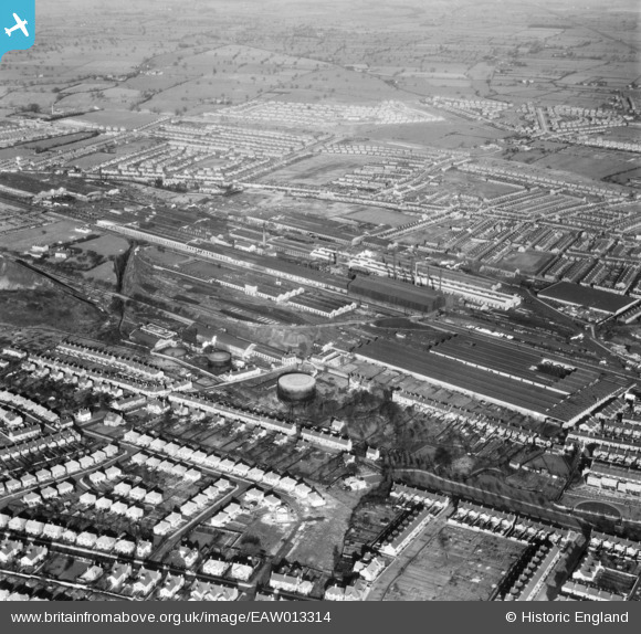
EAW013314 ENGLAND (1948). Crewe Railway Works and environs, Crewe, 1948
© Copyright OpenStreetMap contributors and licensed by the OpenStreetMap Foundation. 2026. Cartography is licensed as CC BY-SA.
Details
| Title | [EAW013314] Crewe Railway Works and environs, Crewe, 1948 |
| Reference | EAW013314 |
| Date | 12-February-1948 |
| Link | |
| Place name | CREWE |
| Parish | |
| District | |
| Country | ENGLAND |
| Easting / Northing | 369596, 355695 |
| Longitude / Latitude | -2.4541111751318, 53.097294131877 |
| National Grid Reference | SJ696557 |
Pins

Malc Hind |
Saturday 22nd of October 2022 09:03:24 PM | |

Creweboy |
Tuesday 15th of January 2019 10:29:39 AM | |

Creweboy |
Tuesday 15th of January 2019 10:29:08 AM | |

Creweboy |
Tuesday 15th of January 2019 10:28:20 AM | |

Creweboy |
Tuesday 15th of January 2019 10:27:50 AM | |

Creweboy |
Tuesday 15th of January 2019 10:27:22 AM | |

Creweboy |
Tuesday 15th of January 2019 10:27:01 AM | |

Creweboy |
Tuesday 15th of January 2019 10:26:05 AM | |

Creweboy |
Tuesday 15th of January 2019 10:24:55 AM | |

Creweboy |
Tuesday 15th of January 2019 10:24:04 AM | |

Creweboy |
Tuesday 15th of January 2019 10:21:58 AM | |

Creweboy |
Tuesday 15th of January 2019 10:21:12 AM | |

Sparky |
Sunday 15th of October 2017 05:40:44 PM | |

Sparky |
Wednesday 26th of July 2017 02:46:33 PM | |

Creweboy |
Sunday 17th of January 2016 09:23:38 PM |


![[EAW013314] Crewe Railway Works and environs, Crewe, 1948](http://britainfromabove.org.uk/sites/all/libraries/aerofilms-images/public/100x100/EAW/013/EAW013314.jpg)
![[EPW017041] The Crewe Works, Crewe, 1926](http://britainfromabove.org.uk/sites/all/libraries/aerofilms-images/public/100x100/EPW/017/EPW017041.jpg)
![[EPW017040] The Crewe Works, Crewe, 1926](http://britainfromabove.org.uk/sites/all/libraries/aerofilms-images/public/100x100/EPW/017/EPW017040.jpg)