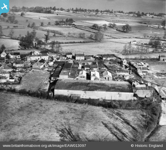
EAW013097 ENGLAND (1948). The Mendip Engineering Works, Atworth, from the south, 1948
© Copyright OpenStreetMap contributors and licensed by the OpenStreetMap Foundation. 2026. Cartography is licensed as CC BY-SA.
Nearby Images (19)
Details
| Title | [EAW013097] The Mendip Engineering Works, Atworth, from the south, 1948 |
| Reference | EAW013097 |
| Date | 21-January-1948 |
| Link | |
| Place name | ATWORTH |
| Parish | ATWORTH |
| District | |
| Country | ENGLAND |
| Easting / Northing | 386805, 165786 |
| Longitude / Latitude | -2.1896588195307, 51.39046504136 |
| National Grid Reference | ST868658 |
Pins

Matt Aldred edob.mattaldred.com |
Friday 3rd of June 2022 01:20:36 PM |


![[EAW013097] The Mendip Engineering Works, Atworth, from the south, 1948](http://britainfromabove.org.uk/sites/all/libraries/aerofilms-images/public/100x100/EAW/013/EAW013097.jpg)
![[EAW013088] The Mendip Engineering Works, Atworth, 1948](http://britainfromabove.org.uk/sites/all/libraries/aerofilms-images/public/100x100/EAW/013/EAW013088.jpg)
![[EAW013016] The New Mendip Engineering Works, Atworth, 1948](http://britainfromabove.org.uk/sites/all/libraries/aerofilms-images/public/100x100/EAW/013/EAW013016.jpg)
![[EAW013017] The New Mendip Engineering Works and environs, Atworth, 1948](http://britainfromabove.org.uk/sites/all/libraries/aerofilms-images/public/100x100/EAW/013/EAW013017.jpg)
![[EAW013089] The Mendip Engineering Works, Atworth, 1948](http://britainfromabove.org.uk/sites/all/libraries/aerofilms-images/public/100x100/EAW/013/EAW013089.jpg)
![[EAW013091] The Mendip Engineering Works, Atworth, 1948](http://britainfromabove.org.uk/sites/all/libraries/aerofilms-images/public/100x100/EAW/013/EAW013091.jpg)
![[EAW013096] The Mendip Engineering Works, Atworth, from the south-east, 1948](http://britainfromabove.org.uk/sites/all/libraries/aerofilms-images/public/100x100/EAW/013/EAW013096.jpg)
![[EAW013093] The Mendip Engineering Works, Atworth, 1948](http://britainfromabove.org.uk/sites/all/libraries/aerofilms-images/public/100x100/EAW/013/EAW013093.jpg)
![[EAW013015] The New Mendip Engineering Works, Atworth, 1948](http://britainfromabove.org.uk/sites/all/libraries/aerofilms-images/public/100x100/EAW/013/EAW013015.jpg)
![[EAW013011] The New Mendip Engineering Works, Atworth, 1948. This image has been produced from a print.](http://britainfromabove.org.uk/sites/all/libraries/aerofilms-images/public/100x100/EAW/013/EAW013011.jpg)
![[EAW013090] The Mendip Engineering Works, Atworth, from the south-east, 1948](http://britainfromabove.org.uk/sites/all/libraries/aerofilms-images/public/100x100/EAW/013/EAW013090.jpg)
![[EAW013094] The Mendip Engineering Works, Atworth, 1948](http://britainfromabove.org.uk/sites/all/libraries/aerofilms-images/public/100x100/EAW/013/EAW013094.jpg)
![[EAW013013] The New Mendip Engineering Works, Atworth, 1948. This image has been produced from a damaged negative.](http://britainfromabove.org.uk/sites/all/libraries/aerofilms-images/public/100x100/EAW/013/EAW013013.jpg)
![[EAW013018] The New Mendip Engineering Works, Atworth, 1948. This image has been produced from a print.](http://britainfromabove.org.uk/sites/all/libraries/aerofilms-images/public/100x100/EAW/013/EAW013018.jpg)
![[EAW013010] The New Mendip Engineering Works, Atworth, from the north-west, 1948. This image has been produced from a print.](http://britainfromabove.org.uk/sites/all/libraries/aerofilms-images/public/100x100/EAW/013/EAW013010.jpg)
![[EAW013095] The Mendip Engineering Works and the surrounding residential area, Atworth, from the west, 1948](http://britainfromabove.org.uk/sites/all/libraries/aerofilms-images/public/100x100/EAW/013/EAW013095.jpg)
![[EAW013012] The New Mendip Engineering Works, Atworth, from the north-east, 1948. This image has been produced from a print.](http://britainfromabove.org.uk/sites/all/libraries/aerofilms-images/public/100x100/EAW/013/EAW013012.jpg)
![[EAW013014] The New Mendip Engineering Works and Bath Road, Atworth, 1948](http://britainfromabove.org.uk/sites/all/libraries/aerofilms-images/public/100x100/EAW/013/EAW013014.jpg)
![[EAW013092] The Mendip Engineering Works, Atworth, from the north-east, 1948](http://britainfromabove.org.uk/sites/all/libraries/aerofilms-images/public/100x100/EAW/013/EAW013092.jpg)