
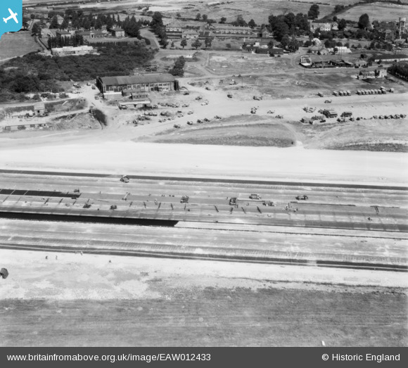
EAW012433 ENGLAND (1947). Bristol Filton Airport under construction, Catbrain, 1947
© Copyright OpenStreetMap contributors and licensed by the OpenStreetMap Foundation. 2026. Cartography is licensed as CC BY-SA.
Nearby Images (17)
EAW012433

EAW009937

EAW009958

EAW012431

EAW009938

EAW013917

EAW009945

EAW013033
 under construction at Bristol Filton Airport, Bristol, 1948. This image has been produced from a damaged negative.")
EAW009929
 under construction at Bristol Filton Airport, Bristol, from the north, 1947")
EAW007033
 under construction at Bristol Filton Airport, Bristol, from the north, 1947")
EAW004173
 under construction at Bristol Filton Airport, Bristol, 1947")
EAW020948
 at Bristol Filton Airport, Bristol, 1949")
EAW007027
 under construction at Bristol Filton Airport, Bristol, 1947")
EAW027406
 at Bristol Filton Airport, Bristol, 1949. This image has been produced from a print marked by Aerofilms Ltd for photo editing.")
EAW026975
 at Bristol Filton Airport, Bristol, 1949. This image has been produced from a print.")
EAW009926
 under construction at Bristol Filton Airport, Bristol, 1947")
EAW026974
 at Bristol Filton Airport, Bristol, 1949. This image has been produced from a print marked by Aerofilms Ltd for photo editing.")
Details
| Title | [EAW012433] Bristol Filton Airport under construction, Catbrain, 1947 |
| Reference | EAW012433 |
| Date | 1947 |
| Link | |
| Place name | CATBRAIN |
| Parish | ALMONDSBURY |
| District | |
| Country | ENGLAND |
| Easting / Northing | 359595, 180220 |
| Longitude / Latitude | -2.5823977226765, 51.51897174179 |
| National Grid Reference | ST596802 |
