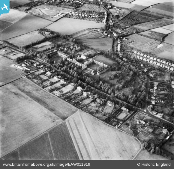
EAW011919 ENGLAND (1947). Girton College and the surrounding area, Girton, 1947
© Copyright OpenStreetMap contributors and licensed by the OpenStreetMap Foundation. 2026. Cartography is licensed as CC BY-SA.
Nearby Images (12)
Details
| Title | [EAW011919] Girton College and the surrounding area, Girton, 1947 |
| Reference | EAW011919 |
| Date | 15-October-1947 |
| Link | |
| Place name | GIRTON |
| Parish | GIRTON |
| District | |
| Country | ENGLAND |
| Easting / Northing | 542457, 260829 |
| Longitude / Latitude | 0.085976133882439, 52.226812962762 |
| National Grid Reference | TL425608 |
Pins
Be the first to add a comment to this image!


![[EAW011919] Girton College and the surrounding area, Girton, 1947](http://britainfromabove.org.uk/sites/all/libraries/aerofilms-images/public/100x100/EAW/011/EAW011919.jpg)
![[EAW011915] Girton College, Girton, 1947](http://britainfromabove.org.uk/sites/all/libraries/aerofilms-images/public/100x100/EAW/011/EAW011915.jpg)
![[EAW011926] Girton College, Girton, 1947](http://britainfromabove.org.uk/sites/all/libraries/aerofilms-images/public/100x100/EAW/011/EAW011926.jpg)
![[EAW011924] Girton College, Girton, 1947](http://britainfromabove.org.uk/sites/all/libraries/aerofilms-images/public/100x100/EAW/011/EAW011924.jpg)
![[EAW011922] Girton College, Girton, 1947](http://britainfromabove.org.uk/sites/all/libraries/aerofilms-images/public/100x100/EAW/011/EAW011922.jpg)
![[EAW011923] Girton College, Girton, 1947](http://britainfromabove.org.uk/sites/all/libraries/aerofilms-images/public/100x100/EAW/011/EAW011923.jpg)
![[EAW011928] Girton College, Girton, 1947](http://britainfromabove.org.uk/sites/all/libraries/aerofilms-images/public/100x100/EAW/011/EAW011928.jpg)
![[EAW011916] Girton College, Huntingdon Road (Roman Road) and the surrounding residential area, Girton, 1947](http://britainfromabove.org.uk/sites/all/libraries/aerofilms-images/public/100x100/EAW/011/EAW011916.jpg)
![[EAW011925] Girton College, Girton, 1947](http://britainfromabove.org.uk/sites/all/libraries/aerofilms-images/public/100x100/EAW/011/EAW011925.jpg)
![[EAW011920] Girton College, Girton, 1947](http://britainfromabove.org.uk/sites/all/libraries/aerofilms-images/public/100x100/EAW/011/EAW011920.jpg)
![[EAW011921] Girton College, Girton, 1947](http://britainfromabove.org.uk/sites/all/libraries/aerofilms-images/public/100x100/EAW/011/EAW011921.jpg)
![[EAW011927] Girton College, Girton, 1947](http://britainfromabove.org.uk/sites/all/libraries/aerofilms-images/public/100x100/EAW/011/EAW011927.jpg)