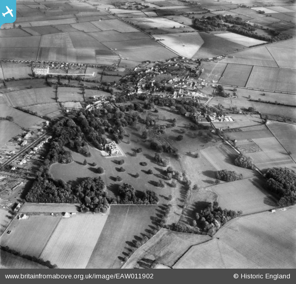
EAW011902 ENGLAND (1947). Branston Hall (County Sanatorium), Branston Park and the village, Branston, 1947
© Copyright OpenStreetMap contributors and licensed by the OpenStreetMap Foundation. 2024. Cartography is licensed as CC BY-SA.
Nearby Images (14)
Details
| Title | [EAW011902] Branston Hall (County Sanatorium), Branston Park and the village, Branston, 1947 |
| Reference | EAW011902 |
| Date | 15-October-1947 |
| Link | |
| Place name | BRANSTON |
| Parish | BRANSTON AND MERE |
| District | |
| Country | ENGLAND |
| Easting / Northing | 501625, 367309 |
| Longitude / Latitude | -0.47872008385575, 53.192858182153 |
| National Grid Reference | TF016673 |
Pins
Be the first to add a comment to this image!


![[EAW011902] Branston Hall (County Sanatorium), Branston Park and the village, Branston, 1947](http://britainfromabove.org.uk/sites/all/libraries/aerofilms-images/public/100x100/EAW/011/EAW011902.jpg)
![[EAW011904] Branston Hall (County Sanatorium), Branston Park and the village, Branston, 1947](http://britainfromabove.org.uk/sites/all/libraries/aerofilms-images/public/100x100/EAW/011/EAW011904.jpg)
![[EAW011906] Branston Hall (County Sanatorium) and Branston Park, Branston, 1947](http://britainfromabove.org.uk/sites/all/libraries/aerofilms-images/public/100x100/EAW/011/EAW011906.jpg)
![[EAW011901] Branston Hall (County Sanatorium) and Branston Park, Branston, 1947](http://britainfromabove.org.uk/sites/all/libraries/aerofilms-images/public/100x100/EAW/011/EAW011901.jpg)
![[EAW011905] Branston Hall (County Sanatorium), Branston, 1947](http://britainfromabove.org.uk/sites/all/libraries/aerofilms-images/public/100x100/EAW/011/EAW011905.jpg)
![[EAW011903] Branston Hall (County Sanatorium) and Branston Park, Branston, 1947](http://britainfromabove.org.uk/sites/all/libraries/aerofilms-images/public/100x100/EAW/011/EAW011903.jpg)
![[EAW011910] Branston Hall (County Sanatorium), Branston, 1947](http://britainfromabove.org.uk/sites/all/libraries/aerofilms-images/public/100x100/EAW/011/EAW011910.jpg)
![[EAW011913] Branston Hall (County Sanatorium), Branston, 1947](http://britainfromabove.org.uk/sites/all/libraries/aerofilms-images/public/100x100/EAW/011/EAW011913.jpg)
![[EAW011909] Branston Hall (County Sanatorium), Branston, 1947](http://britainfromabove.org.uk/sites/all/libraries/aerofilms-images/public/100x100/EAW/011/EAW011909.jpg)
![[EAW011907] Branston Hall (County Sanatorium), Branston, 1947](http://britainfromabove.org.uk/sites/all/libraries/aerofilms-images/public/100x100/EAW/011/EAW011907.jpg)
![[EAW011911] Branston Hall (County Sanatorium), Branston, 1947](http://britainfromabove.org.uk/sites/all/libraries/aerofilms-images/public/100x100/EAW/011/EAW011911.jpg)
![[EAW011914] Branston Hall (County Sanatorium), Branston, 1947](http://britainfromabove.org.uk/sites/all/libraries/aerofilms-images/public/100x100/EAW/011/EAW011914.jpg)
![[EAW011908] Branston Hall (County Sanatorium), Branston, 1947](http://britainfromabove.org.uk/sites/all/libraries/aerofilms-images/public/100x100/EAW/011/EAW011908.jpg)
![[EAW011912] Branston Hall (County Sanatorium), Branston, from the south-west, 1947](http://britainfromabove.org.uk/sites/all/libraries/aerofilms-images/public/100x100/EAW/011/EAW011912.jpg)