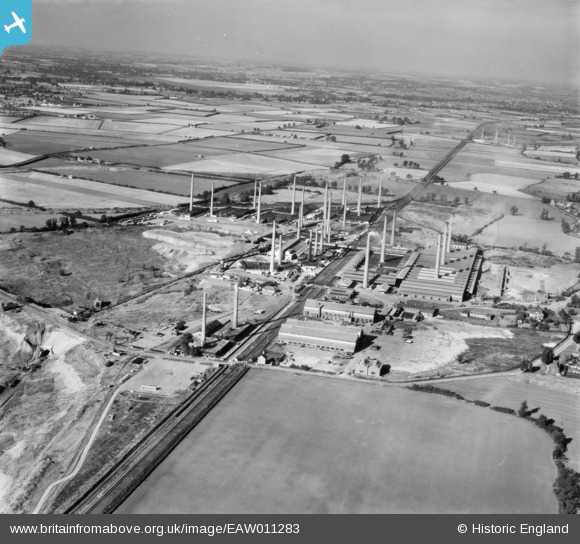
EAW011283 ENGLAND (1947). The London Brick Company Stewartby Brickworks and environs, Stewartby, from the south, 1947
© Copyright OpenStreetMap contributors and licensed by the OpenStreetMap Foundation. 2026. Cartography is licensed as CC BY-SA.
Nearby Images (16)
Details
| Title | [EAW011283] The London Brick Company Stewartby Brickworks and environs, Stewartby, from the south, 1947 |
| Reference | EAW011283 |
| Date | 30-September-1947 |
| Link | |
| Place name | STEWARTBY |
| Parish | STEWARTBY |
| District | |
| Country | ENGLAND |
| Easting / Northing | 501547, 242230 |
| Longitude / Latitude | -0.51836139505625, 52.068701524608 |
| National Grid Reference | TL015422 |
Pins
Be the first to add a comment to this image!


![[EAW011283] The London Brick Company Stewartby Brickworks and environs, Stewartby, from the south, 1947](http://britainfromabove.org.uk/sites/all/libraries/aerofilms-images/public/100x100/EAW/011/EAW011283.jpg)
![[EPW054976] The London Brick Co Works, Stewartby, from the south-west, 1937](http://britainfromabove.org.uk/sites/all/libraries/aerofilms-images/public/100x100/EPW/054/EPW054976.jpg)
![[EPW054975] The London Brick Co Works, Stewartby, from the south-west, 1937](http://britainfromabove.org.uk/sites/all/libraries/aerofilms-images/public/100x100/EPW/054/EPW054975.jpg)
![[EAW011274] The London Brick Company Stewartby Brickworks and environs, Marston Moretaine, 1947](http://britainfromabove.org.uk/sites/all/libraries/aerofilms-images/public/100x100/EAW/011/EAW011274.jpg)
![[EPW033893] Pillinge Brickworks and Wootton Pillinge, Stewartby, 1930](http://britainfromabove.org.uk/sites/all/libraries/aerofilms-images/public/100x100/EPW/033/EPW033893.jpg)
![[EAW011281] The London Brick Company Stewartby Brickworks and environs, Marston Moretaine, 1947](http://britainfromabove.org.uk/sites/all/libraries/aerofilms-images/public/100x100/EAW/011/EAW011281.jpg)
![[EAW011273] The London Brick Company Stewartby Brickworks and environs, Stewartby, 1947](http://britainfromabove.org.uk/sites/all/libraries/aerofilms-images/public/100x100/EAW/011/EAW011273.jpg)
![[EPW049674] The Pillinge Brick Works and environs, Stewartby, from the south-east, 1936](http://britainfromabove.org.uk/sites/all/libraries/aerofilms-images/public/100x100/EPW/049/EPW049674.jpg)
![[EPW033891] Pillinge Brickworks, Stewartby, from the south, 1930](http://britainfromabove.org.uk/sites/all/libraries/aerofilms-images/public/100x100/EPW/033/EPW033891.jpg)
![[EPW054978] The London Brick Co Works, Stewartby, 1937](http://britainfromabove.org.uk/sites/all/libraries/aerofilms-images/public/100x100/EPW/054/EPW054978.jpg)
![[EPW054977] The London Brick Co Works, Stewartby, from the south-west, 1937](http://britainfromabove.org.uk/sites/all/libraries/aerofilms-images/public/100x100/EPW/054/EPW054977.jpg)
![[EAW011275] The London Brick Company Stewartby Brickworks and environs, Stewartby, 1947](http://britainfromabove.org.uk/sites/all/libraries/aerofilms-images/public/100x100/EAW/011/EAW011275.jpg)
![[EPW054972] The London Brick Co Works, Stewartby, from the south, 1937](http://britainfromabove.org.uk/sites/all/libraries/aerofilms-images/public/100x100/EPW/054/EPW054972.jpg)
![[EPW049679] The Pillinge Brick Works and environs, Stewartby, from the south-west, 1936](http://britainfromabove.org.uk/sites/all/libraries/aerofilms-images/public/100x100/EPW/049/EPW049679.jpg)
![[EPW026690] The London Brick Company and Forders Ltd Pillinge Brick Works, Stewartby, from the south-west, 1929](http://britainfromabove.org.uk/sites/all/libraries/aerofilms-images/public/100x100/EPW/026/EPW026690.jpg)
![[EAW011282] The London Brick Company Stewartby Brickworks and environs, Stewartby, from the south-west, 1947](http://britainfromabove.org.uk/sites/all/libraries/aerofilms-images/public/100x100/EAW/011/EAW011282.jpg)