
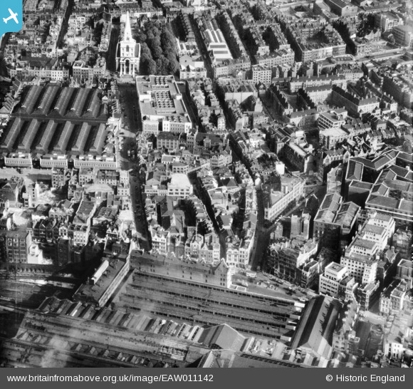
EAW011142 ENGLAND (1947). Brushfield Street and environs, Spitalfields, 1947
© Copyright OpenStreetMap contributors and licensed by the OpenStreetMap Foundation. 2026. Cartography is licensed as CC BY-SA.
Nearby Images (8)
EAW011142

EAW011378

EAW011379

EAW026317

EAW011143
 at Devonshire Square and environs, London, 1947")
EAW011141

EAW011377

EAW011194

Details
| Title | [EAW011142] Brushfield Street and environs, Spitalfields, 1947 |
| Reference | EAW011142 |
| Date | 30-September-1947 |
| Link | |
| Place name | SPITALFIELDS |
| Parish | |
| District | |
| Country | ENGLAND |
| Easting / Northing | 533458, 181705 |
| Longitude / Latitude | -0.076303473024027, 51.517997471658 |
| National Grid Reference | TQ335817 |
Pins

theheadshed |
Friday 12th of March 2021 04:36:14 AM | |
|
theheadshed |
Friday 12th of March 2021 04:34:37 AM | |
|
theheadshed |
Friday 12th of March 2021 04:29:35 AM | |
|
justgnat |
Friday 15th of November 2019 02:39:28 PM | |

Class31 |
Monday 12th of May 2014 01:28:26 PM | |
|
Class31 |
Monday 12th of May 2014 01:26:01 PM | |

Alan McFaden |
Thursday 12th of December 2013 03:49:43 PM | |
|
Alan McFaden |
Tuesday 5th of November 2013 08:55:09 PM | |
|
Alan McFaden |
Tuesday 5th of November 2013 08:53:49 PM | |
|
Alan McFaden |
Tuesday 5th of November 2013 08:52:16 PM |


User Comment Contributions
View is looking east. |
Class31 |
Monday 12th of May 2014 01:28:58 PM |