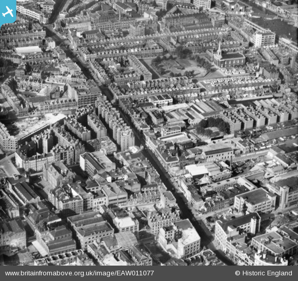
EAW011077 ENGLAND (1947). Goswell Road, King Square and environs, St Luke's, 1947
    © Copyright OpenStreetMap contributors and licensed by the OpenStreetMap Foundation. 2025. Cartography is licensed as CC BY-SA.
  
Nearby Images (9)
Details
| Title | [EAW011077] Goswell Road, King Square and environs, St Luke's, 1947 | 
| Reference | EAW011077 | 
| Date | 30-October-1947 | 
| Link | |
| Place name | ST LUKE'S | 
| Parish | |
| District | |
| Country | ENGLAND | 
| Easting / Northing | 531932, 182468 | 
| Longitude / Latitude | -0.098000754316182, 51.525213481689 | 
| National Grid Reference | TQ319825 | 
Pins
|  City Road Basin of the Regents Canal. |   Nowy Paul | Saturday 16th of June 2018 01:59:24 PM | 
|  Trolleybus on route 677 from West India Dock heading for the "Smithfield" terminus in St John Street. |   Nowy Paul | Saturday 16th of June 2018 01:57:50 PM | 
|  Percival Street, EC1 |   billyfern | Tuesday 24th of June 2014 07:43:10 PM | 
|  Moreland Street, EC1 |   billyfern | Tuesday 24th of June 2014 04:36:57 PM | 
|  Prefabs, Lever Street & King Square, EC1 |   billyfern | Tuesday 24th of June 2014 04:35:52 PM | 
|  Lever Street, EC1 |   billyfern | Tuesday 24th of June 2014 04:35:32 PM | 
|  St. Barnabas Church, King Square, EC1
(changed to St. Clements Church - No longer here) |   billyfern | Tuesday 24th of June 2014 04:34:14 PM | 
| Am I missing something here. I took a photograph of this church on 16th June 2014. Some clarification would be helpful. | Class31 | Tuesday 22nd of July 2014 09:32:47 AM | 
|  Goswell Road, EC1 |   billyfern | Tuesday 24th of June 2014 04:31:37 PM | 
| Class31 | Tuesday 17th of June 2014 08:50:26 PM | |
| Class31 | Tuesday 17th of June 2014 08:44:30 PM | |
| Class31 | Tuesday 17th of June 2014 08:42:20 PM | |
| Class31 | Tuesday 17th of June 2014 08:41:05 PM | |
|  PoutStudios |   lesauvage | Monday 4th of November 2013 12:54:49 PM | 
 
             
  ![[EAW011077] Goswell Road, King Square and environs, St Luke's, 1947](http://britainfromabove.org.uk/sites/all/libraries/aerofilms-images/public/100x100/EAW/011/EAW011077.jpg) 
  
                                          ![[EAW011119] The Triangle, Seward Street and environs, St Luke's, 1947. This image has been produced from a print.](http://britainfromabove.org.uk/sites/all/libraries/aerofilms-images/public/100x100/EAW/011/EAW011119.jpg) 
 ![[EAW011101] The Triangle, Percival Road and environs, St Luke's, 1947](http://britainfromabove.org.uk/sites/all/libraries/aerofilms-images/public/100x100/EAW/011/EAW011101.jpg) 
 ![[EAW010075] The area between Clerkenwell Road and Spencer Street, Clerkenwell, 1947](http://britainfromabove.org.uk/sites/all/libraries/aerofilms-images/public/100x100/EAW/010/EAW010075.jpg) 
 ![[EAW011214] The junction of Goswell Road and Old Street with cleared site off Gee Street, St Luke's, 1947](http://britainfromabove.org.uk/sites/all/libraries/aerofilms-images/public/100x100/EAW/011/EAW011214.jpg) 
 ![[EAW011078] Northampton Square and environs, Finsbury, 1947](http://britainfromabove.org.uk/sites/all/libraries/aerofilms-images/public/100x100/EAW/011/EAW011078.jpg) 
 ![[EAW011104] Sekforde Street, Compton Street and environs, St Luke's, 1947](http://britainfromabove.org.uk/sites/all/libraries/aerofilms-images/public/100x100/EAW/011/EAW011104.jpg) 
 ![[EAW011213] The Cannon Brewery, St John Street and environs, St Luke's, 1947](http://britainfromabove.org.uk/sites/all/libraries/aerofilms-images/public/100x100/EAW/011/EAW011213.jpg) 
 ![[EAW011118] Old Street, the Peabody Estate and piles of rubble off Goswell Street following clearance of bomb damaged sites, St Luke's, 1947](http://britainfromabove.org.uk/sites/all/libraries/aerofilms-images/public/100x100/EAW/011/EAW011118.jpg)