
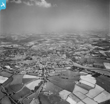
EAW010745 ENGLAND (1947). The town and surrounding countryside, Truro, from the south-west, 1947

© Copyright OpenStreetMap contributors and licensed by the OpenStreetMap Foundation. 2026. Cartography is licensed as CC BY-SA.
Details
| Title | [EAW010745] The town and surrounding countryside, Truro, from the south-west, 1947 |
| Reference | EAW010745 |
| Date | 10-September-1947 |
| Link | |
| Place name | TRURO |
| Parish | TRURO |
| District | |
| Country | ENGLAND |
| Easting / Northing | 182414, 44208 |
| Longitude / Latitude | -5.0529298228533, 50.257096045666 |
| National Grid Reference | SW824442 |
Pins

forostar |
Tuesday 31st of December 2019 01:15:58 PM | |
|
forostar |
Tuesday 31st of December 2019 01:15:28 PM | |
|
forostar |
Tuesday 31st of December 2019 01:14:06 PM | |
|
forostar |
Tuesday 31st of December 2019 01:13:20 PM | |
|
CornwallPhil |
Tuesday 15th of July 2014 09:05:31 PM | |
|
CornwallPhil |
Tuesday 15th of July 2014 09:02:20 PM | |
|
CornwallPhil |
Tuesday 15th of July 2014 08:57:41 PM | |
|
CornwallPhil |
Tuesday 15th of July 2014 08:56:12 PM | |
|
CornwallPhil |
Tuesday 15th of July 2014 08:51:48 PM |
User Comment Contributions
Various WW2 sites and events |
CornwallPhil |
Tuesday 15th of July 2014 09:06:46 PM |