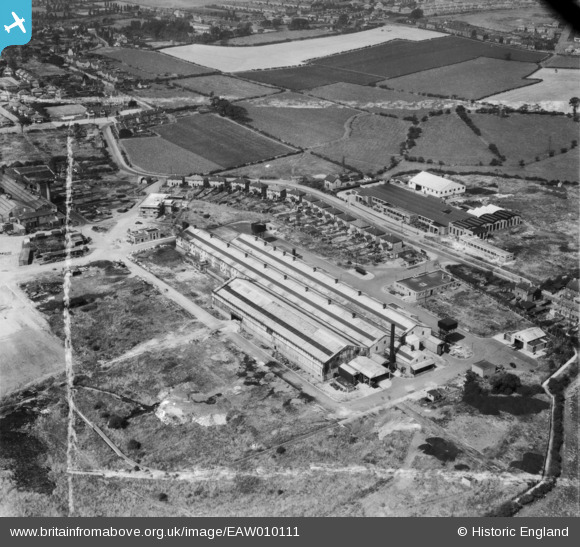
EAW010111 ENGLAND (1947). The Weldless Steel Tube Works on Waddens Brook Lane, Wednesfield, 1947. This image was marked by Aerofilms Ltd for photo editing.
© Copyright OpenStreetMap contributors and licensed by the OpenStreetMap Foundation. 2026. Cartography is licensed as CC BY-SA.
Nearby Images (11)
Details
| Title | [EAW010111] The Weldless Steel Tube Works on Waddens Brook Lane, Wednesfield, 1947. This image was marked by Aerofilms Ltd for photo editing. |
| Reference | EAW010111 |
| Date | 29-August-1947 |
| Link | |
| Place name | WEDNESFIELD |
| Parish | |
| District | |
| Country | ENGLAND |
| Easting / Northing | 395423, 299948 |
| Longitude / Latitude | -2.0675800103942, 52.59695048559 |
| National Grid Reference | SO954999 |
Pins

WendyV |
Monday 13th of October 2014 04:10:19 PM | |

WendyV |
Monday 13th of October 2014 04:08:26 PM | |

WendyV |
Monday 13th of October 2014 04:07:24 PM | |

WendyV |
Monday 13th of October 2014 04:06:14 PM | |

WendyV |
Monday 13th of October 2014 04:04:02 PM | |

WendyV |
Monday 13th of October 2014 04:03:22 PM | |

WendyV |
Monday 13th of October 2014 04:02:26 PM | |

WendyV |
Monday 13th of October 2014 03:59:37 PM |


![[EAW010111] The Weldless Steel Tube Works on Waddens Brook Lane, Wednesfield, 1947. This image was marked by Aerofilms Ltd for photo editing.](http://britainfromabove.org.uk/sites/all/libraries/aerofilms-images/public/100x100/EAW/010/EAW010111.jpg)
![[EAW010108] The Weldless Steel Tube Works on Waddens Brook Lane, Wednesfield, 1947. This image was marked by Aerofilms Ltd for photo editing.](http://britainfromabove.org.uk/sites/all/libraries/aerofilms-images/public/100x100/EAW/010/EAW010108.jpg)
![[EAW010112] The Weldless Steel Tube Works on Waddens Brook Lane, Wednesfield, 1947](http://britainfromabove.org.uk/sites/all/libraries/aerofilms-images/public/100x100/EAW/010/EAW010112.jpg)
![[EAW010109] The Weldless Steel Tube Works on Waddens Brook Lane, Wednesfield, 1947. This image was marked by Aerofilms Ltd for photo editing.](http://britainfromabove.org.uk/sites/all/libraries/aerofilms-images/public/100x100/EAW/010/EAW010109.jpg)
![[EAW010106] The Weldless Steel Tube Works on Waddens Brook Lane, Wednesfield, 1947. This image was marked by Aerofilms Ltd for photo editing.](http://britainfromabove.org.uk/sites/all/libraries/aerofilms-images/public/100x100/EAW/010/EAW010106.jpg)
![[EAW010115] The Weldless Steel Tube Works on Waddens Brook Lane, Wednesfield, from the north-west, 1947. This image was marked by Aerofilms Ltd for photo editing.](http://britainfromabove.org.uk/sites/all/libraries/aerofilms-images/public/100x100/EAW/010/EAW010115.jpg)
![[EAW010114] The Weldless Steel Tube Works on Waddens Brook Lane, Wednesfield, 1947](http://britainfromabove.org.uk/sites/all/libraries/aerofilms-images/public/100x100/EAW/010/EAW010114.jpg)
![[EAW010107] The Weldless Steel Tube Works on Waddens Brook Lane, Wednesfield, 1947. This image was marked by Aerofilms Ltd for photo editing.](http://britainfromabove.org.uk/sites/all/libraries/aerofilms-images/public/100x100/EAW/010/EAW010107.jpg)
![[EAW010110] The Weldless Steel Tube Works on Waddens Brook Lane, Wednesfield, 1947. This image was marked by Aerofilms Ltd for photo editing.](http://britainfromabove.org.uk/sites/all/libraries/aerofilms-images/public/100x100/EAW/010/EAW010110.jpg)
![[EAW010113] The Weldless Steel Tube Works on Waddens Brook Lane, Wednesfield, 1947](http://britainfromabove.org.uk/sites/all/libraries/aerofilms-images/public/100x100/EAW/010/EAW010113.jpg)
![[EAW010105] The Weldless Steel Tube Works on Waddens Brook Lane, Wednesfield, 1947. This image was marked by Aerofilms Ltd for photo editing.](http://britainfromabove.org.uk/sites/all/libraries/aerofilms-images/public/100x100/EAW/010/EAW010105.jpg)