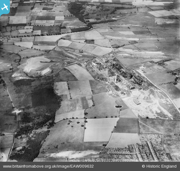
EAW009632 ENGLAND (1947). The John Lysaght Normanby Park Steel Works, Scunthorpe, 1947
© Copyright OpenStreetMap contributors and licensed by the OpenStreetMap Foundation. 2026. Cartography is licensed as CC BY-SA.
Nearby Images (20)
Details
| Title | [EAW009632] The John Lysaght Normanby Park Steel Works, Scunthorpe, 1947 |
| Reference | EAW009632 |
| Date | 16-August-1947 |
| Link | |
| Place name | SCUNTHORPE |
| Parish | |
| District | |
| Country | ENGLAND |
| Easting / Northing | 488511, 413738 |
| Longitude / Latitude | -0.66193853922849, 53.612468228472 |
| National Grid Reference | SE885137 |
Pins

redmist |
Tuesday 29th of January 2019 02:57:00 PM |


![[EAW009632] The John Lysaght Normanby Park Steel Works, Scunthorpe, 1947](http://britainfromabove.org.uk/sites/all/libraries/aerofilms-images/public/100x100/EAW/009/EAW009632.jpg)
![[EPW048532] The John Lysaght Normanby Park Steel Works, Scunthorpe, from the west, 1935](http://britainfromabove.org.uk/sites/all/libraries/aerofilms-images/public/100x100/EPW/048/EPW048532.jpg)
![[EPW016305] The Frodingham Iron Works, Scunthorpe, from the south-west, 1926](http://britainfromabove.org.uk/sites/all/libraries/aerofilms-images/public/100x100/EPW/016/EPW016305.jpg)
![[EAW009638] The John Lysaght Normanby Park Steel Works, Scunthorpe, 1947](http://britainfromabove.org.uk/sites/all/libraries/aerofilms-images/public/100x100/EAW/009/EAW009638.jpg)
![[EAW038762] Part of the John Lysaght Ltd Normanby Park Steel Works, Scunthorpe, 1951. This image has been produced from a print marked by Aerofilms Ltd for photo editing.](http://britainfromabove.org.uk/sites/all/libraries/aerofilms-images/public/100x100/EAW/038/EAW038762.jpg)
![[EAW009409] The John Lysaght Normanby Park Steel Works, Scunthorpe, from the south-west, 1947. This image has been produced from a print.](http://britainfromabove.org.uk/sites/all/libraries/aerofilms-images/public/100x100/EAW/009/EAW009409.jpg)
![[EAW034806] Part of the John Lysaght Normanby Park Steel Works, Scunthorpe, from the south-west, 1951. This image has been produced from a print.](http://britainfromabove.org.uk/sites/all/libraries/aerofilms-images/public/100x100/EAW/034/EAW034806.jpg)
![[EAW009636] The John Lysaght Normanby Park Steel Works, Scunthorpe, 1947](http://britainfromabove.org.uk/sites/all/libraries/aerofilms-images/public/100x100/EAW/009/EAW009636.jpg)
![[EAW038761] John Lysaght Ltd Normanby Park Steel Works, Scunthorpe, 1951. This image has been produced from a print.](http://britainfromabove.org.uk/sites/all/libraries/aerofilms-images/public/100x100/EAW/038/EAW038761.jpg)
![[EAW049665] The John Lysaght Normanby Park Steel Works, Scunthorpe, 1953. This image was marked by Aerofilms Ltd for photo editing.](http://britainfromabove.org.uk/sites/all/libraries/aerofilms-images/public/100x100/EAW/049/EAW049665.jpg)
![[EAW034812] Part of the John Lysaght Normanby Park Steel Works, Scunthorpe, 1951. This image has been produced from a print.](http://britainfromabove.org.uk/sites/all/libraries/aerofilms-images/public/100x100/EAW/034/EAW034812.jpg)
![[EAW041855] Part of the John Lysaght Normanby Park Steel Works, Scunthorpe, 1952. This image has been produced from a print marked by Aerofilms Ltd for photo editing.](http://britainfromabove.org.uk/sites/all/libraries/aerofilms-images/public/100x100/EAW/041/EAW041855.jpg)
![[EAW041859] Part of the John Lysaght Normanby Park Steel Works, Scunthorpe, 1952. This image has been produced from a print marked by Aerofilms Ltd for photo editing.](http://britainfromabove.org.uk/sites/all/libraries/aerofilms-images/public/100x100/EAW/041/EAW041859.jpg)
![[EPW048943] The John Lysaght Normanby Park Steel Works, Scunthorpe, 1935. This image has been produced from a damaged negative.](http://britainfromabove.org.uk/sites/all/libraries/aerofilms-images/public/100x100/EPW/048/EPW048943.jpg)
![[EAW041856] Part of the John Lysaght Normanby Park Steel Works, Scunthorpe, 1952. This image has been produced from a print marked by Aerofilms Ltd for photo editing.](http://britainfromabove.org.uk/sites/all/libraries/aerofilms-images/public/100x100/EAW/041/EAW041856.jpg)
![[EAW049663] The John Lysaght Normanby Park Steel Works, Scunthorpe, 1953. This image was marked by Aerofilms Ltd for photo editing.](http://britainfromabove.org.uk/sites/all/libraries/aerofilms-images/public/100x100/EAW/049/EAW049663.jpg)
![[EAW041853] Part of the John Lysaght Normanby Park Steel Works, Scunthorpe, 1952. This image has been produced from a print marked by Aerofilms Ltd for photo editing.](http://britainfromabove.org.uk/sites/all/libraries/aerofilms-images/public/100x100/EAW/041/EAW041853.jpg)
![[EAW027173] The John Lysaght Normanby Park Steel Works, Scunthorpe, 1949. This image has been produced from a print.](http://britainfromabove.org.uk/sites/all/libraries/aerofilms-images/public/100x100/EAW/027/EAW027173.jpg)
![[EAW031187] The John Lysaght Normanby Park Steel Works, Scunthorpe, 1950](http://britainfromabove.org.uk/sites/all/libraries/aerofilms-images/public/100x100/EAW/031/EAW031187.jpg)
![[EAW041847] Part of the John Lysaght Normanby Park Steel Works, Scunthorpe, from the south-west, 1952. This image has been produced from a print marked by Aerofilms Ltd for photo editing.](http://britainfromabove.org.uk/sites/all/libraries/aerofilms-images/public/100x100/EAW/041/EAW041847.jpg)