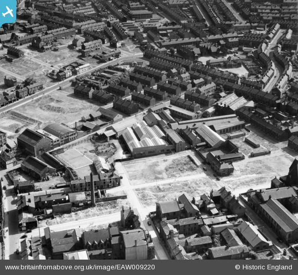
EAW009220 ENGLAND (1947). Wilson & Longbottom Ltd Nelson Foundry and environs, Barnsley, 1947
© Copyright OpenStreetMap contributors and licensed by the OpenStreetMap Foundation. 2026. Cartography is licensed as CC BY-SA.
Nearby Images (11)
Details
| Title | [EAW009220] Wilson & Longbottom Ltd Nelson Foundry and environs, Barnsley, 1947 |
| Reference | EAW009220 |
| Date | 16-August-1947 |
| Link | |
| Place name | BARNSLEY |
| Parish | |
| District | |
| Country | ENGLAND |
| Easting / Northing | 434383, 406035 |
| Longitude / Latitude | -1.4809991754431, 53.549577127775 |
| National Grid Reference | SE344060 |


![[EAW009220] Wilson & Longbottom Ltd Nelson Foundry and environs, Barnsley, 1947](http://britainfromabove.org.uk/sites/all/libraries/aerofilms-images/public/100x100/EAW/009/EAW009220.jpg)
![[EAW009211] Wilson & Longbottom Ltd Nelson Foundry and environs, Barnsley, 1947](http://britainfromabove.org.uk/sites/all/libraries/aerofilms-images/public/100x100/EAW/009/EAW009211.jpg)
![[EAW009217] Wilson & Longbottom Ltd Nelson Foundry, Barnsley, 1947](http://britainfromabove.org.uk/sites/all/libraries/aerofilms-images/public/100x100/EAW/009/EAW009217.jpg)
![[EAW009212] Wilson & Longbottom Ltd Nelson Foundry and environs, Barnsley, 1947](http://britainfromabove.org.uk/sites/all/libraries/aerofilms-images/public/100x100/EAW/009/EAW009212.jpg)
![[EAW009216] Wilson & Longbottom Ltd Nelson Foundry and environs, Barnsley, 1947](http://britainfromabove.org.uk/sites/all/libraries/aerofilms-images/public/100x100/EAW/009/EAW009216.jpg)
![[EAW009215] Wilson & Longbottom Ltd Nelson Foundry and environs, Barnsley, 1947](http://britainfromabove.org.uk/sites/all/libraries/aerofilms-images/public/100x100/EAW/009/EAW009215.jpg)
![[EAW009219] Wilson & Longbottom Ltd Nelson Foundry and environs, Barnsley, 1947](http://britainfromabove.org.uk/sites/all/libraries/aerofilms-images/public/100x100/EAW/009/EAW009219.jpg)
![[EAW009214] Wilson & Longbottom Ltd Nelson Foundry and environs, Barnsley, 1947](http://britainfromabove.org.uk/sites/all/libraries/aerofilms-images/public/100x100/EAW/009/EAW009214.jpg)
![[EAW009213] Wilson & Longbottom Ltd Nelson Foundry and environs, Barnsley, 1947](http://britainfromabove.org.uk/sites/all/libraries/aerofilms-images/public/100x100/EAW/009/EAW009213.jpg)
![[EAW009218] Wilson & Longbottom Ltd Nelson Foundry and environs, Barnsley, 1947](http://britainfromabove.org.uk/sites/all/libraries/aerofilms-images/public/100x100/EAW/009/EAW009218.jpg)
![[EPW057293] The town centre, Barnsley, 1938](http://britainfromabove.org.uk/sites/all/libraries/aerofilms-images/public/100x100/EPW/057/EPW057293.jpg)
