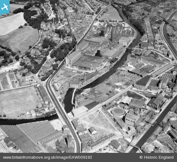
EAW009192 ENGLAND (1947). Mills along the River Aire including the Airedale Combing Co Mill and Lower Holme Mills, Baildon, 1947
© Copyright OpenStreetMap contributors and licensed by the OpenStreetMap Foundation. 2024. Cartography is licensed as CC BY-SA.
Nearby Images (12)
Details
| Title | [EAW009192] Mills along the River Aire including the Airedale Combing Co Mill and Lower Holme Mills, Baildon, 1947 |
| Reference | EAW009192 |
| Date | 16-August-1947 |
| Link | |
| Place name | BAILDON |
| Parish | BAILDON |
| District | |
| Country | ENGLAND |
| Easting / Northing | 415160, 437994 |
| Longitude / Latitude | -1.7695969647385, 53.837766800057 |
| National Grid Reference | SE152380 |
Pins
 Shipley Flyer |
Monday 13th of March 2017 04:39:18 PM |
User Comment Contributions
Site of Current Carnaud Metalbox. At this time there were 4 filter beds |
 Shipley Flyer |
Wednesday 8th of March 2017 05:40:39 PM |


![[EAW009192] Mills along the River Aire including the Airedale Combing Co Mill and Lower Holme Mills, Baildon, 1947](http://britainfromabove.org.uk/sites/all/libraries/aerofilms-images/public/100x100/EAW/009/EAW009192.jpg)
![[EAW009196] The Airedale Combing Co Mill and environs, Baildon, 1947](http://britainfromabove.org.uk/sites/all/libraries/aerofilms-images/public/100x100/EAW/009/EAW009196.jpg)
![[EAW009195] The Airedale Combing Co Mill, Baildon, 1947](http://britainfromabove.org.uk/sites/all/libraries/aerofilms-images/public/100x100/EAW/009/EAW009195.jpg)
![[EAW009190] The Airedale Combing Co Mill, Baildon, 1947](http://britainfromabove.org.uk/sites/all/libraries/aerofilms-images/public/100x100/EAW/009/EAW009190.jpg)
![[EAW009197] The Airedale Combing Co Mill, Baildon, 1947](http://britainfromabove.org.uk/sites/all/libraries/aerofilms-images/public/100x100/EAW/009/EAW009197.jpg)
![[EAW009193] The Airedale Combing Co Mill, Baildon, 1947](http://britainfromabove.org.uk/sites/all/libraries/aerofilms-images/public/100x100/EAW/009/EAW009193.jpg)
![[EAW009188] The Airedale Combing Co Mill, Baildon, 1947](http://britainfromabove.org.uk/sites/all/libraries/aerofilms-images/public/100x100/EAW/009/EAW009188.jpg)
![[EAW009194] The Airedale Combing Co Mill and Lower Holme Mills, Baildon, 1947](http://britainfromabove.org.uk/sites/all/libraries/aerofilms-images/public/100x100/EAW/009/EAW009194.jpg)
![[EAW009189] Mills along the River Aire including the Airedale Combing Co Mill and Lower Holme Mills, Baildon, 1947](http://britainfromabove.org.uk/sites/all/libraries/aerofilms-images/public/100x100/EAW/009/EAW009189.jpg)
![[EAW009191] The Airedale Combing Co Mill, Baildon, 1947](http://britainfromabove.org.uk/sites/all/libraries/aerofilms-images/public/100x100/EAW/009/EAW009191.jpg)
![[EAW009186] The Airedale Combing Co Mill and Lower Holme Mills and environs, Baildon, 1947](http://britainfromabove.org.uk/sites/all/libraries/aerofilms-images/public/100x100/EAW/009/EAW009186.jpg)
![[EAW009187] The Airedale Combing Co Mill and environs, Baildon, 1947](http://britainfromabove.org.uk/sites/all/libraries/aerofilms-images/public/100x100/EAW/009/EAW009187.jpg)