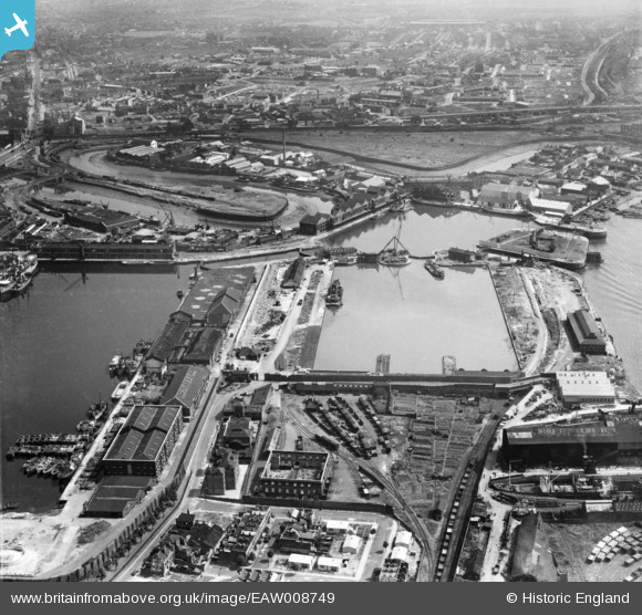
EAW008749 ENGLAND (1947). The East India Docks, Blackwall, 1947
© Copyright OpenStreetMap contributors and licensed by the OpenStreetMap Foundation. 2026. Cartography is licensed as CC BY-SA.
Nearby Images (48)
Details
| Title | [EAW008749] The East India Docks, Blackwall, 1947 |
| Reference | EAW008749 |
| Date | 8-August-1947 |
| Link | |
| Place name | BLACKWALL |
| Parish | |
| District | |
| Country | ENGLAND |
| Easting / Northing | 538868, 180864 |
| Longitude / Latitude | 0.0012960612158112, 51.509135148932 |
| National Grid Reference | TQ389809 |
Pins

CH |
Tuesday 11th of March 2025 07:55:01 PM | |

CH |
Tuesday 11th of March 2025 07:52:38 PM | |

Leslie B |
Tuesday 5th of April 2016 11:44:24 PM |


![[EAW008749] The East India Docks, Blackwall, 1947](http://britainfromabove.org.uk/sites/all/libraries/aerofilms-images/public/100x100/EAW/008/EAW008749.jpg)
![[EAW013365] The East India Docks, Blackwall, 1948. This image was marked by Aerofilms Ltd for photo editing.](http://britainfromabove.org.uk/sites/all/libraries/aerofilms-images/public/100x100/EAW/013/EAW013365.jpg)
![[EAW004329] The East India Dock and Dock Basin, Blackwall, 1947](http://britainfromabove.org.uk/sites/all/libraries/aerofilms-images/public/100x100/EAW/004/EAW004329.jpg)
![[EAW004325] The East India Docks, Blackwall, 1947](http://britainfromabove.org.uk/sites/all/libraries/aerofilms-images/public/100x100/EAW/004/EAW004325.jpg)
![[EAW013359] The East India Docks, Blackwall, 1948](http://britainfromabove.org.uk/sites/all/libraries/aerofilms-images/public/100x100/EAW/013/EAW013359.jpg)
![[EAW008752] Brunswick Wharf Generating Station and the East India Dock Basin, Blackwall, 1947. This image has been produced from a print.](http://britainfromabove.org.uk/sites/all/libraries/aerofilms-images/public/100x100/EAW/008/EAW008752.jpg)
![[EAW024921] Brunswick Wharf Generating Station under construction and East India (Import) Dock, Blackwall, 1949. This image was marked by Aerofilms Ltd for photo editing.](http://britainfromabove.org.uk/sites/all/libraries/aerofilms-images/public/100x100/EAW/024/EAW024921.jpg)
![[EAW004328] The East India Dock and Dock Basin, Blackwall, 1947](http://britainfromabove.org.uk/sites/all/libraries/aerofilms-images/public/100x100/EAW/004/EAW004328.jpg)
![[EAW024916] Brunswick Wharf Generating Station under construction, Blackwall, 1949. This image was marked by Aerofilms Ltd for photo editing.](http://britainfromabove.org.uk/sites/all/libraries/aerofilms-images/public/100x100/EAW/024/EAW024916.jpg)
![[EAW013625] The East India Docks, Blackwall, 1948. This image was marked by Aerofilms Ltd for photo editing.](http://britainfromabove.org.uk/sites/all/libraries/aerofilms-images/public/100x100/EAW/013/EAW013625.jpg)
![[EAW008754] Brunswick Wharf Generating Station, East India Dock Basin and the River Lea, Blackwall, 1947. This image has been produced from a print.](http://britainfromabove.org.uk/sites/all/libraries/aerofilms-images/public/100x100/EAW/008/EAW008754.jpg)
![[EAW013628] The East India Docks, Blackwall, 1948](http://britainfromabove.org.uk/sites/all/libraries/aerofilms-images/public/100x100/EAW/013/EAW013628.jpg)
![[EAW024922] Brunswick Wharf Generating Station under construction and environs, Blackwall, 1949. This image was marked by Aerofilms Ltd for photo editing.](http://britainfromabove.org.uk/sites/all/libraries/aerofilms-images/public/100x100/EAW/024/EAW024922.jpg)
![[EAW013631] The East India Docks, Blackwall, 1948. This image was marked by Aerofilms Ltd for photo editing.](http://britainfromabove.org.uk/sites/all/libraries/aerofilms-images/public/100x100/EAW/013/EAW013631.jpg)
![[EAW013630] The East India Docks, Blackwall, 1948. This image was marked by Aerofilms Ltd for photo editing.](http://britainfromabove.org.uk/sites/all/libraries/aerofilms-images/public/100x100/EAW/013/EAW013630.jpg)
![[EAW004330] The East India Docks, Blackwall, 1947](http://britainfromabove.org.uk/sites/all/libraries/aerofilms-images/public/100x100/EAW/004/EAW004330.jpg)
![[EAW024918] Brunswick Wharf Generating Station under construction, Blackwall, 1949](http://britainfromabove.org.uk/sites/all/libraries/aerofilms-images/public/100x100/EAW/024/EAW024918.jpg)
![[EAW008751] The East India Docks, Blackwall, 1947. This image has been produced from a damaged negative.](http://britainfromabove.org.uk/sites/all/libraries/aerofilms-images/public/100x100/EAW/008/EAW008751.jpg)
![[EAW024917] Brunswick Wharf Generating Station under construction, Blackwall, 1949. This image was marked by Aerofilms Ltd for photo editing.](http://britainfromabove.org.uk/sites/all/libraries/aerofilms-images/public/100x100/EAW/024/EAW024917.jpg)
![[EAW004327] The East India Dock, Blackwall, 1947](http://britainfromabove.org.uk/sites/all/libraries/aerofilms-images/public/100x100/EAW/004/EAW004327.jpg)
![[EAW013629] The East India Docks, Blackwall, 1948. This image was marked by Aerofilms Ltd for photo editing.](http://britainfromabove.org.uk/sites/all/libraries/aerofilms-images/public/100x100/EAW/013/EAW013629.jpg)
![[EAW024914] Brunswick Wharf Generating Station under construction and East India (Import) Dock, Blackwall, 1949](http://britainfromabove.org.uk/sites/all/libraries/aerofilms-images/public/100x100/EAW/024/EAW024914.jpg)
![[EAW008750] The East India Docks, Blackwall, 1947](http://britainfromabove.org.uk/sites/all/libraries/aerofilms-images/public/100x100/EAW/008/EAW008750.jpg)
![[EAW013627] The East India Docks, Blackwall, 1948. This image was marked by Aerofilms Ltd for photo editing.](http://britainfromabove.org.uk/sites/all/libraries/aerofilms-images/public/100x100/EAW/013/EAW013627.jpg)
![[EAW013366] The East India Docks, Blackwall, 1948. This image was marked by Aerofilms Ltd for photo editing.](http://britainfromabove.org.uk/sites/all/libraries/aerofilms-images/public/100x100/EAW/013/EAW013366.jpg)
![[EAW004332] The East India Docks, Blackwall, 1947](http://britainfromabove.org.uk/sites/all/libraries/aerofilms-images/public/100x100/EAW/004/EAW004332.jpg)
![[EAW013360] The East India Docks, Blackwall, 1948. This image was marked by Aerofilms Ltd for photo editing.](http://britainfromabove.org.uk/sites/all/libraries/aerofilms-images/public/100x100/EAW/013/EAW013360.jpg)
![[EAW013364] The East India Docks, Blackwall, 1948. This image was marked by Aerofilms Ltd for photo editing.](http://britainfromabove.org.uk/sites/all/libraries/aerofilms-images/public/100x100/EAW/013/EAW013364.jpg)
![[EAW024920] Brunswick Wharf Generating Station under construction and environs, Blackwall, 1949. This image was marked by Aerofilms Ltd for photo editing.](http://britainfromabove.org.uk/sites/all/libraries/aerofilms-images/public/100x100/EAW/024/EAW024920.jpg)
![[EPW009112] The East India Docks and environs, Blackwall, 1923. This image has been produced from a copy-negative.](http://britainfromabove.org.uk/sites/all/libraries/aerofilms-images/public/100x100/EPW/009/EPW009112.jpg)
![[EPW005311] East India Docks, Blackwall, 1921](http://britainfromabove.org.uk/sites/all/libraries/aerofilms-images/public/100x100/EPW/005/EPW005311.jpg)
![[EAW024919] Brunswick Wharf Generating Station under construction, Blackwall, 1949. This image was marked by Aerofilms Ltd for photo editing.](http://britainfromabove.org.uk/sites/all/libraries/aerofilms-images/public/100x100/EAW/024/EAW024919.jpg)
![[EAW024915] Brunswick Wharf Generating Station under construction, Blackwall, 1949. This image was marked by Aerofilms Ltd for photo editing.](http://britainfromabove.org.uk/sites/all/libraries/aerofilms-images/public/100x100/EAW/024/EAW024915.jpg)
![[EAW012154] East India Docks, Blackwall, 1947. This image was marked by Aerofilms Ltd for photo editing.](http://britainfromabove.org.uk/sites/all/libraries/aerofilms-images/public/100x100/EAW/012/EAW012154.jpg)
![[EAW053005] Brunswick Wharf (Blackwall) Power Station, East India Docks and environs, Blackwall, 1953](http://britainfromabove.org.uk/sites/all/libraries/aerofilms-images/public/100x100/EAW/053/EAW053005.jpg)
![[EPW036253] The D-LZ 127 Graf Zeppelin over the East India Docks and the River Thames, Blackwall, 1931](http://britainfromabove.org.uk/sites/all/libraries/aerofilms-images/public/100x100/EPW/036/EPW036253.jpg)
![[EAW013624] The East India Export Dock, Blackwall, 1948. This image was marked by Aerofilms Ltd for photo editing.](http://britainfromabove.org.uk/sites/all/libraries/aerofilms-images/public/100x100/EAW/013/EAW013624.jpg)
![[EAW013633] Construction work for the Brunswick Wharf Power Station at the East India Export Dock, Blackwall, 1948](http://britainfromabove.org.uk/sites/all/libraries/aerofilms-images/public/100x100/EAW/013/EAW013633.jpg)
![[EAW013626] The East India Docks, Blackwall, from the south-west, 1948. This image was marked by Aerofilms Ltd for photo editing.](http://britainfromabove.org.uk/sites/all/libraries/aerofilms-images/public/100x100/EAW/013/EAW013626.jpg)
![[EAW004331] The East India Dock alongside the River Thames, Blackwall, 1947](http://britainfromabove.org.uk/sites/all/libraries/aerofilms-images/public/100x100/EAW/004/EAW004331.jpg)
![[EPW011938] The East India Docks and environs, Blackwall, 1924. This image has been produced from a copy-negative.](http://britainfromabove.org.uk/sites/all/libraries/aerofilms-images/public/100x100/EPW/011/EPW011938.jpg)
![[EAW008753] Brunswick Wharf Generating Station, Blackwall, 1947. This image has been produced from a print.](http://britainfromabove.org.uk/sites/all/libraries/aerofilms-images/public/100x100/EAW/008/EAW008753.jpg)
![[EAW004326] The East India Dock, Blackwall, 1947](http://britainfromabove.org.uk/sites/all/libraries/aerofilms-images/public/100x100/EAW/004/EAW004326.jpg)
![[EAW012155] East India Dock (Export), Blackwall, 1947. This image was marked by Aerofilms Ltd for photo editing.](http://britainfromabove.org.uk/sites/all/libraries/aerofilms-images/public/100x100/EAW/012/EAW012155.jpg)
![[EAW013362] The East India Docks, Blackwall, 1948. This image has been produced from a damaged negative.](http://britainfromabove.org.uk/sites/all/libraries/aerofilms-images/public/100x100/EAW/013/EAW013362.jpg)
![[EAW012157] East India Dock (Export), Blackwall, 1947. This image was marked by Aerofilms Ltd for photo editing.](http://britainfromabove.org.uk/sites/all/libraries/aerofilms-images/public/100x100/EAW/012/EAW012157.jpg)
![[EAW012156] East India Dock (Export), Blackwall, 1947. This image was marked by Aerofilms Ltd for photo editing.](http://britainfromabove.org.uk/sites/all/libraries/aerofilms-images/public/100x100/EAW/012/EAW012156.jpg)
![[EAW029485] Brunswick Wharf Power Station under construction and the surrounding docks and river, Blackwall, 1950](http://britainfromabove.org.uk/sites/all/libraries/aerofilms-images/public/100x100/EAW/029/EAW029485.jpg)