
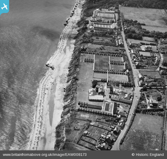
EAW008173 ENGLAND (1947). Corton Holiday Camp at Manor Farm, Corton, 1947
© Copyright OpenStreetMap contributors and licensed by the OpenStreetMap Foundation. 2026. Cartography is licensed as CC BY-SA.
Nearby Images (13)
EAW008173

EAW008177

EAW008172

EAW008174

EAW008176

EAW008178

EAW008183

EAW008175

EAW008182

EAW008179

EAW008181

EAW008180

EAW008184

Details
| Title | [EAW008173] Corton Holiday Camp at Manor Farm, Corton, 1947 |
| Reference | EAW008173 |
| Date | 12-July-1947 |
| Link | |
| Place name | CORTON |
| Parish | CORTON |
| District | |
| Country | ENGLAND |
| Easting / Northing | 654393, 297528 |
| Longitude / Latitude | 1.7499144591848, 52.515781773652 |
| National Grid Reference | TM544975 |
Pins

redmist |
Saturday 7th of December 2024 08:32:06 PM | |
|
FenderTelecaster |
Wednesday 27th of May 2020 06:17:44 PM | |
|
Al |
Friday 6th of December 2013 03:53:24 PM | |
Hiya, these are the remains of the old promenade that Jeremiah James Colman built below his home Cliff House. He built a sea wall and promenade in 1897. At about the same time he provided Corton with its Village Hall and United Methodist Chapel, and he was the main contributor to the fund for building a School. He built many of the houses in Corton for his staff. You can still see J.J.C. inscribed on the brickwork. Cliffe House was eventually demolished in 1917, but the gardens were sold and became one of Cortons first holiday attractions. |
Pip |
Friday 19th of December 2014 01:28:44 PM |