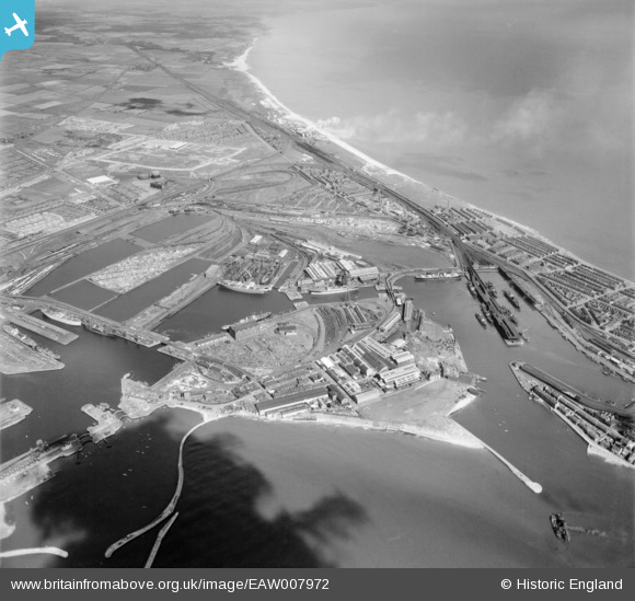
EAW007972 ENGLAND (1947). The Old Harbour and the docks, Hartlepool, 1947
© Copyright OpenStreetMap contributors and licensed by the OpenStreetMap Foundation. 2026. Cartography is licensed as CC BY-SA.
Nearby Images (6)
Details
| Title | [EAW007972] The Old Harbour and the docks, Hartlepool, 1947 |
| Reference | EAW007972 |
| Date | 26-June-1947 |
| Link | |
| Place name | HARTLEPOOL |
| Parish | |
| District | |
| Country | ENGLAND |
| Easting / Northing | 451752, 533878 |
| Longitude / Latitude | -1.1969274462868, 54.697162575663 |
| National Grid Reference | NZ518339 |
Pins

redmist |
Friday 30th of September 2022 07:49:46 PM | |

redmist |
Friday 30th of September 2022 03:18:32 PM | |

redmist |
Friday 30th of September 2022 03:17:05 PM | |

redmist |
Friday 30th of September 2022 03:16:25 PM | |

Matt Aldred edob.mattaldred.com |
Friday 12th of March 2021 12:50:08 AM | |

redmist |
Wednesday 23rd of September 2020 12:09:02 PM | |

redmist |
Wednesday 23rd of September 2020 12:08:12 PM | |

redmist |
Wednesday 23rd of September 2020 12:03:30 PM | |

redmist |
Wednesday 23rd of September 2020 12:01:18 PM | |

redmist |
Wednesday 23rd of September 2020 12:00:56 PM | |

redmist |
Wednesday 23rd of September 2020 11:59:58 AM | |

redmist |
Wednesday 23rd of September 2020 11:59:16 AM | |

redmist |
Wednesday 23rd of September 2020 11:58:42 AM | |

Dylan Moore |
Sunday 16th of February 2014 10:25:15 PM |


![[EAW007972] The Old Harbour and the docks, Hartlepool, 1947](http://britainfromabove.org.uk/sites/all/libraries/aerofilms-images/public/100x100/EAW/007/EAW007972.jpg)
![[EPW010609] Central Marine Engine Works and environs, Hartlepool, 1924](http://britainfromabove.org.uk/sites/all/libraries/aerofilms-images/public/100x100/EPW/010/EPW010609.jpg)
![[EPW010608] Central Marine Engine Works and environs, Hartlepool, 1924](http://britainfromabove.org.uk/sites/all/libraries/aerofilms-images/public/100x100/EPW/010/EPW010608.jpg)
![[EAW003185] The Old Harbour, the North Basin and the Hartlepool Engine Works, Hartlepool, from the north-west, 1946](http://britainfromabove.org.uk/sites/all/libraries/aerofilms-images/public/100x100/EAW/003/EAW003185.jpg)
![[EPW010601] The Central Shipbuilding Yard, Hartlepool, 1924](http://britainfromabove.org.uk/sites/all/libraries/aerofilms-images/public/100x100/EPW/010/EPW010601.jpg)
![[EAW003186] The Old Harbour, the Hartlepool Engine Works and Hartlepool Bay, Hartlepool, from the north-west, 1946](http://britainfromabove.org.uk/sites/all/libraries/aerofilms-images/public/100x100/EAW/003/EAW003186.jpg)