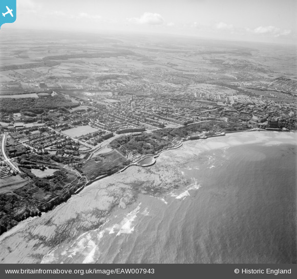
EAW007943 ENGLAND (1947). South Cliff and Weaponness, Scarborough, from the south-east, 1947
    © Copyright OpenStreetMap contributors and licensed by the OpenStreetMap Foundation. 2025. Cartography is licensed as CC BY-SA.
  
Nearby Images (5)
Details
| Title | [EAW007943] South Cliff and Weaponness, Scarborough, from the south-east, 1947 | 
| Reference | EAW007943 | 
| Date | 26-July-1947 | 
| Link | |
| Place name | SCARBOROUGH | 
| Parish | |
| District | |
| Country | ENGLAND | 
| Easting / Northing | 505041, 487335 | 
| Longitude / Latitude | -0.38682655161263, 54.270704717182 | 
| National Grid Reference | TA050873 | 
Pins
|  Approx location of a 2ndWW Spigot Mortar mounting. |   redmist | Monday 9th of March 2020 07:51:22 PM | 
|  Irton Moor (Wireless Station) |   garfield70 | Wednesday 6th of November 2019 02:41:27 PM | 
 
             
  ![[EAW007943] South Cliff and Weaponness, Scarborough, from the south-east, 1947](http://britainfromabove.org.uk/sites/all/libraries/aerofilms-images/public/100x100/EAW/007/EAW007943.jpg) 
  
                                          ![[EAW007938] South Cliff and Weaponness, Scarborough, from the south-east, 1947](http://britainfromabove.org.uk/sites/all/libraries/aerofilms-images/public/100x100/EAW/007/EAW007938.jpg) 
 ![[EAW007940] South Cliff and Weaponness, Scarborough, from the south-east, 1947](http://britainfromabove.org.uk/sites/all/libraries/aerofilms-images/public/100x100/EAW/007/EAW007940.jpg) 
 ![[EAW007939] South Cliff and Weaponness, Scarborough, from the south-east, 1947](http://britainfromabove.org.uk/sites/all/libraries/aerofilms-images/public/100x100/EAW/007/EAW007939.jpg) 
 ![[EAW007974] South Bay and the town, Scarborough, from the south-east, 1947](http://britainfromabove.org.uk/sites/all/libraries/aerofilms-images/public/100x100/EAW/007/EAW007974.jpg)