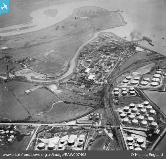
EAW007463 ENGLAND (1947). Part of the Coryton Oil Refinery complex, Coryton, 1947
© Copyright OpenStreetMap contributors and licensed by the OpenStreetMap Foundation. 2026. Cartography is licensed as CC BY-SA.
Nearby Images (8)
Details
| Title | [EAW007463] Part of the Coryton Oil Refinery complex, Coryton, 1947 |
| Reference | EAW007463 |
| Date | 25-June-1947 |
| Link | |
| Place name | CORYTON |
| Parish | |
| District | |
| Country | ENGLAND |
| Easting / Northing | 573888, 181985 |
| Longitude / Latitude | 0.50607267092022, 51.509514937868 |
| National Grid Reference | TQ739820 |
Pins

cptpies |
Tuesday 10th of October 2017 04:13:44 PM | |

cptpies |
Tuesday 10th of October 2017 04:09:13 PM | |

cptpies |
Tuesday 10th of October 2017 04:08:48 PM | |

cptpies |
Tuesday 10th of October 2017 04:04:16 PM |


![[EAW007463] Part of the Coryton Oil Refinery complex, Coryton, 1947](http://britainfromabove.org.uk/sites/all/libraries/aerofilms-images/public/100x100/EAW/007/EAW007463.jpg)
![[EAW021801] The Shell Haven Oil Refinery, Thames Haven, 1949](http://britainfromabove.org.uk/sites/all/libraries/aerofilms-images/public/100x100/EAW/021/EAW021801.jpg)
![[EAW007459] Part of the Coryton Oil Refinery complex, Coryton, 1947](http://britainfromabove.org.uk/sites/all/libraries/aerofilms-images/public/100x100/EAW/007/EAW007459.jpg)
![[EAW007454] Part of the Coryton Oil Refinery complex, Coryton, 1947](http://britainfromabove.org.uk/sites/all/libraries/aerofilms-images/public/100x100/EAW/007/EAW007454.jpg)
![[EAW007455] Part of the Coryton Oil Refinery complex, Coryton, 1947. This image has been produced from a print.](http://britainfromabove.org.uk/sites/all/libraries/aerofilms-images/public/100x100/EAW/007/EAW007455.jpg)
![[EAW007458] Part of the Coryton Oil Refinery complex, Coryton, 1947](http://britainfromabove.org.uk/sites/all/libraries/aerofilms-images/public/100x100/EAW/007/EAW007458.jpg)
![[EAW003535] Oil Storage Tanks at Thames Haven, Coryton, 1947](http://britainfromabove.org.uk/sites/all/libraries/aerofilms-images/public/100x100/EAW/003/EAW003535.jpg)
![[EAW003536] Thames Haven Goods Station and Oil Refinery at Shell Haven Creek, Coryton, 1947](http://britainfromabove.org.uk/sites/all/libraries/aerofilms-images/public/100x100/EAW/003/EAW003536.jpg)