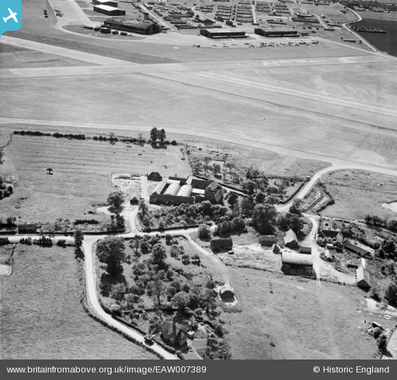
EAW007389 ENGLAND (1947). Lower Farm and RAF Pershore, Throckmorton, 1947
© Copyright OpenStreetMap contributors and licensed by the OpenStreetMap Foundation. 2025. Cartography is licensed as CC BY-SA.
Nearby Images (5)
Details
| Title | [EAW007389] Lower Farm and RAF Pershore, Throckmorton, 1947 |
| Reference | EAW007389 |
| Date | 12-June-1947 |
| Link | |
| Place name | THROCKMORTON |
| Parish | THROCKMORTON |
| District | |
| Country | ENGLAND |
| Easting / Northing | 397932, 249709 |
| Longitude / Latitude | -2.0302243984128, 52.145258315883 |
| National Grid Reference | SO979497 |
Pins
 ken |
Saturday 11th of July 2015 09:45:27 PM | |
 ken |
Saturday 11th of July 2015 09:44:08 PM | |
 clippedwings |
Saturday 14th of March 2015 09:27:03 PM | |
 clippedwings |
Saturday 14th of March 2015 09:22:47 PM | |
 clippedwings |
Sunday 15th of February 2015 10:07:09 PM | |
 calladhor |
Friday 10th of October 2014 02:31:12 PM | |
 calladhor |
Friday 10th of October 2014 02:30:24 PM | |
 MB |
Tuesday 12th of November 2013 01:28:27 PM | |
From nearest: Anson, Anson; Oxford and Mosquito. |
 calladhor |
Friday 10th of October 2014 02:28:44 PM |
User Comment Contributions
RAF Pershore was built in 1940 and was initially the home of No. 23 Operational Training Unit, which employed Vickers Wellingtons. No. 1 Ferry Unit was later based here. Information from the Throckmorton site on Wikipedia. |
 MB |
Tuesday 12th of November 2013 01:26:08 PM |


![[EAW007389] Lower Farm and RAF Pershore, Throckmorton, 1947](http://britainfromabove.org.uk/sites/all/libraries/aerofilms-images/public/100x100/EAW/007/EAW007389.jpg)
![[EAW007385] Lower Farm and environs, Throckmorton, 1947](http://britainfromabove.org.uk/sites/all/libraries/aerofilms-images/public/100x100/EAW/007/EAW007385.jpg)
![[EAW007388] The village, Throckmorton, 1947](http://britainfromabove.org.uk/sites/all/libraries/aerofilms-images/public/100x100/EAW/007/EAW007388.jpg)
![[EAW007383] The village, Throckmorton, 1947](http://britainfromabove.org.uk/sites/all/libraries/aerofilms-images/public/100x100/EAW/007/EAW007383.jpg)
![[EAW007391] The village, Throckmorton, 1947](http://britainfromabove.org.uk/sites/all/libraries/aerofilms-images/public/100x100/EAW/007/EAW007391.jpg)