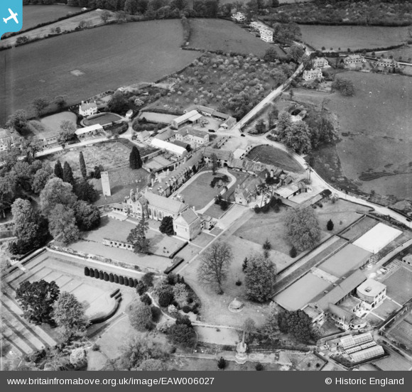
EAW006027 ENGLAND (1947). Dartington Hall, Dartington, 1947
© Copyright OpenStreetMap contributors and licensed by the OpenStreetMap Foundation. 2025. Cartography is licensed as CC BY-SA.
Nearby Images (13)
Details
| Title | [EAW006027] Dartington Hall, Dartington, 1947 |
| Reference | EAW006027 |
| Date | 18-May-1947 |
| Link | |
| Place name | DARTINGTON |
| Parish | DARTINGTON |
| District | |
| Country | ENGLAND |
| Easting / Northing | 279854, 62705 |
| Longitude / Latitude | -3.6925481137184, 50.451262127572 |
| National Grid Reference | SX799627 |
Pins
 longshot |
Monday 4th of November 2013 06:17:25 PM |


![[EAW006027] Dartington Hall, Dartington, 1947](http://britainfromabove.org.uk/sites/all/libraries/aerofilms-images/public/100x100/EAW/006/EAW006027.jpg)
![[EAW006022] Dartington Hall, Dartington, 1947](http://britainfromabove.org.uk/sites/all/libraries/aerofilms-images/public/100x100/EAW/006/EAW006022.jpg)
![[EAW007595] Dartington Hall and the remains of St Mary's Church, Dartington, 1947. This image has been produced from a print.](http://britainfromabove.org.uk/sites/all/libraries/aerofilms-images/public/100x100/EAW/007/EAW007595.jpg)
![[EAW006024] Dartington Hall, Dartington, 1947](http://britainfromabove.org.uk/sites/all/libraries/aerofilms-images/public/100x100/EAW/006/EAW006024.jpg)
![[EAW007596] Dartington Hall and the remains of St Mary's Church, Dartington, 1947. This image has been produced from a print.](http://britainfromabove.org.uk/sites/all/libraries/aerofilms-images/public/100x100/EAW/007/EAW007596.jpg)
![[EAW006025] Dartington Hall, Dartington, 1947. This image was marked by Aerofilms Ltd for photo editing.](http://britainfromabove.org.uk/sites/all/libraries/aerofilms-images/public/100x100/EAW/006/EAW006025.jpg)
![[EAW007593] Dartington Hall, Dartington, 1947. This image has been produced from a print.](http://britainfromabove.org.uk/sites/all/libraries/aerofilms-images/public/100x100/EAW/007/EAW007593.jpg)
![[EAW006026] Dartington Hall, Dartington, 1947](http://britainfromabove.org.uk/sites/all/libraries/aerofilms-images/public/100x100/EAW/006/EAW006026.jpg)
![[EAW007592] Dartington Hall, Dartington, 1947. This image has been produced from a print.](http://britainfromabove.org.uk/sites/all/libraries/aerofilms-images/public/100x100/EAW/007/EAW007592.jpg)
![[EAW007594] Dartington Hall, Dartington, 1947](http://britainfromabove.org.uk/sites/all/libraries/aerofilms-images/public/100x100/EAW/007/EAW007594.jpg)
![[EAW006023] Dartington Hall, Dartington, 1947. This image was marked by Aerofilms Ltd for photo editing.](http://britainfromabove.org.uk/sites/all/libraries/aerofilms-images/public/100x100/EAW/006/EAW006023.jpg)
![[EAW006028] Dartington Hall, Dartington, 1947. This image was marked by Aerofilms Ltd for photo editing.](http://britainfromabove.org.uk/sites/all/libraries/aerofilms-images/public/100x100/EAW/006/EAW006028.jpg)
![[EAW007591A] Dartington Hall, Dartington, 1947](http://britainfromabove.org.uk/sites/all/libraries/aerofilms-images/public/100x100/EAW/007/EAW007591A.jpg)