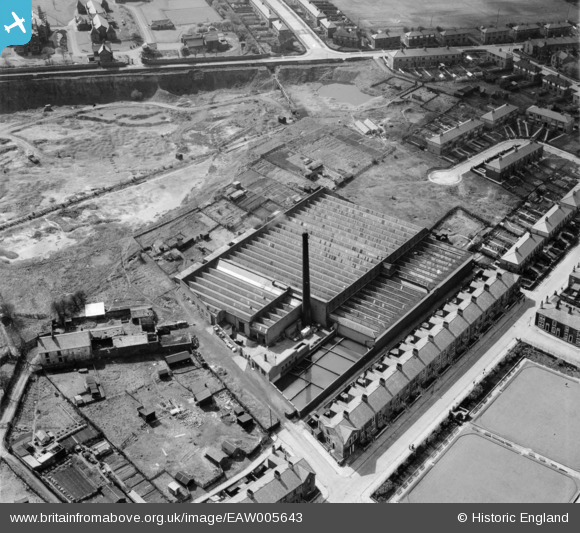
EAW005643 ENGLAND (1947). The Longshaw Cotton and Rayon Weaving Mill, Blackburn, 1947
© Copyright OpenStreetMap contributors and licensed by the OpenStreetMap Foundation. 2026. Cartography is licensed as CC BY-SA.
Nearby Images (15)
Details
| Title | [EAW005643] The Longshaw Cotton and Rayon Weaving Mill, Blackburn, 1947 |
| Reference | EAW005643 |
| Date | 15-May-1947 |
| Link | |
| Place name | BLACKBURN |
| Parish | |
| District | |
| Country | ENGLAND |
| Easting / Northing | 368393, 426752 |
| Longitude / Latitude | -2.4792059387677, 53.735975337806 |
| National Grid Reference | SD684268 |
Pins

Roger |
Friday 25th of October 2024 08:50:07 PM | |

redmist |
Friday 22nd of March 2019 09:16:44 AM | |

powerpop |
Sunday 17th of January 2016 05:16:41 PM | |

powerpop |
Sunday 17th of January 2016 05:15:53 PM | |

powerpop |
Sunday 17th of January 2016 05:15:23 PM | |

powerpop |
Tuesday 28th of October 2014 07:18:24 PM |


![[EAW005643] The Longshaw Cotton and Rayon Weaving Mill, Blackburn, 1947](http://britainfromabove.org.uk/sites/all/libraries/aerofilms-images/public/100x100/EAW/005/EAW005643.jpg)
![[EAW005642] The Longshaw Cotton and Rayon Weaving Mill, Blackburn, 1947. This image was marked by Aerofilms Ltd for photo editing.](http://britainfromabove.org.uk/sites/all/libraries/aerofilms-images/public/100x100/EAW/005/EAW005642.jpg)
![[EAW005640] The Longshaw Cotton and Rayon Weaving Mill, Blackburn, 1947. This image was marked by Aerofilms Ltd for photo editing.](http://britainfromabove.org.uk/sites/all/libraries/aerofilms-images/public/100x100/EAW/005/EAW005640.jpg)
![[EAW005641] The Longshaw Cotton and Rayon Weaving Mill, Blackburn, 1947](http://britainfromabove.org.uk/sites/all/libraries/aerofilms-images/public/100x100/EAW/005/EAW005641.jpg)
![[EAW005639] The Longshaw Cotton and Rayon Weaving Mill, Blackburn, 1947](http://britainfromabove.org.uk/sites/all/libraries/aerofilms-images/public/100x100/EAW/005/EAW005639.jpg)
![[EAW005644] The Longshaw Cotton and Rayon Weaving Mill, Blackburn, 1947](http://britainfromabove.org.uk/sites/all/libraries/aerofilms-images/public/100x100/EAW/005/EAW005644.jpg)
![[EAW045372] Mosley Street and the Frederick Textiles Ltd Albert Mills and adjacent mills on the Leeds & Liverpool Canal, Blackburn, 1952. This image was marked by Aerofilms Ltd for photo editing.](http://britainfromabove.org.uk/sites/all/libraries/aerofilms-images/public/100x100/EAW/045/EAW045372.jpg)
![[EAW045374] The Frederick Textiles Ltd Albert Mills and adjacent mills on the Leeds & Liverpool Canal, Blackburn, 1952. This image was marked by Aerofilms Ltd for photo editing.](http://britainfromabove.org.uk/sites/all/libraries/aerofilms-images/public/100x100/EAW/045/EAW045374.jpg)
![[EAW045368] The Frederick Textiles Ltd Albert Mills and adjacent mills on the Leeds & Liverpool Canal, Blackburn, 1952. This image was marked by Aerofilms Ltd for photo editing.](http://britainfromabove.org.uk/sites/all/libraries/aerofilms-images/public/100x100/EAW/045/EAW045368.jpg)
![[EAW045373] Mosley Street and the Frederick Textiles Ltd Albert Mills and adjacent mills on the Leeds & Liverpool Canal, Blackburn, 1952. This image was marked by Aerofilms Ltd for photo editing.](http://britainfromabove.org.uk/sites/all/libraries/aerofilms-images/public/100x100/EAW/045/EAW045373.jpg)
![[EAW045371] The Frederick Textiles Ltd Albert Mills and adjacent mills on the Leeds & Liverpool Canal, Blackburn, 1952. This image was marked by Aerofilms Ltd for photo editing.](http://britainfromabove.org.uk/sites/all/libraries/aerofilms-images/public/100x100/EAW/045/EAW045371.jpg)
![[EAW045370] The Frederick Textiles Ltd Albert Mills and adjacent mills on the Leeds & Liverpool Canal, Blackburn, 1952. This image was marked by Aerofilms Ltd for photo editing.](http://britainfromabove.org.uk/sites/all/libraries/aerofilms-images/public/100x100/EAW/045/EAW045370.jpg)
![[EAW045367] The Frederick Textiles Ltd Albert Mills and adjacent mills on the Leeds & Liverpool Canal, Blackburn, 1952. This image was marked by Aerofilms Ltd for photo editing.](http://britainfromabove.org.uk/sites/all/libraries/aerofilms-images/public/100x100/EAW/045/EAW045367.jpg)
![[EAW045369] The Frederick Textiles Ltd Albert Mills and adjacent mills on the Leeds & Liverpool Canal, Blackburn, 1952. This image was marked by Aerofilms Ltd for photo editing.](http://britainfromabove.org.uk/sites/all/libraries/aerofilms-images/public/100x100/EAW/045/EAW045369.jpg)
![[EAW045375] The Frederick Textiles Ltd Albert Mills and adjacent mills on the Leeds & Liverpool Canal, Blackburn, 1952. This image was marked by Aerofilms Ltd for photo editing.](http://britainfromabove.org.uk/sites/all/libraries/aerofilms-images/public/100x100/EAW/045/EAW045375.jpg)