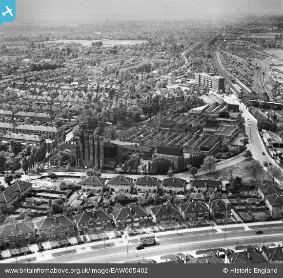
EAW005402 ENGLAND (1947). Wall's Ice Cream and Sausage Factory and environs, Acton, from the north-east, 1947
© Copyright OpenStreetMap contributors and licensed by the OpenStreetMap Foundation. 2026. Cartography is licensed as CC BY-SA.
Nearby Images (28)
Details
| Title | [EAW005402] Wall's Ice Cream and Sausage Factory and environs, Acton, from the north-east, 1947 |
| Reference | EAW005402 |
| Date | 17-May-1947 |
| Link | |
| Place name | ACTON |
| Parish | |
| District | |
| Country | ENGLAND |
| Easting / Northing | 520699, 181213 |
| Longitude / Latitude | -0.26028734664116, 51.516446238487 |
| National Grid Reference | TQ207812 |
Pins

Matt Aldred edob.mattaldred.com |
Saturday 25th of March 2023 01:30:48 PM | |

Sparky |
Monday 7th of August 2017 08:35:13 AM |


![[EAW005402] Wall's Ice Cream and Sausage Factory and environs, Acton, from the north-east, 1947](http://britainfromabove.org.uk/sites/all/libraries/aerofilms-images/public/100x100/EAW/005/EAW005402.jpg)
![[EPW037286] Wall's Ice Cream and Sausage Factory, Acton, 1932](http://britainfromabove.org.uk/sites/all/libraries/aerofilms-images/public/100x100/EPW/037/EPW037286.jpg)
![[EPW037290] Wall's Ice Cream and Sausage Factory, Acton, 1932](http://britainfromabove.org.uk/sites/all/libraries/aerofilms-images/public/100x100/EPW/037/EPW037290.jpg)
![[EPW037284] Wall's Ice Cream and Sausage Factory and environs, Acton, 1932](http://britainfromabove.org.uk/sites/all/libraries/aerofilms-images/public/100x100/EPW/037/EPW037284.jpg)
![[EAW005398] Wall's Ice Cream and Sausage Factory and environs, Acton, 1947](http://britainfromabove.org.uk/sites/all/libraries/aerofilms-images/public/100x100/EAW/005/EAW005398.jpg)
![[EAW005396] Wall's Ice Cream and Sausage Factory and environs, Acton, 1947](http://britainfromabove.org.uk/sites/all/libraries/aerofilms-images/public/100x100/EAW/005/EAW005396.jpg)
![[EPW037287] Wall's Ice Cream and Sausage Factory and environs, Acton, 1932](http://britainfromabove.org.uk/sites/all/libraries/aerofilms-images/public/100x100/EPW/037/EPW037287.jpg)
![[EPW037291] Wall's Ice Cream and Sausage Factory, Acton, 1932](http://britainfromabove.org.uk/sites/all/libraries/aerofilms-images/public/100x100/EPW/037/EPW037291.jpg)
![[EAW005406] Wall's Ice Cream and Sausage Factory and environs, Acton, 1947](http://britainfromabove.org.uk/sites/all/libraries/aerofilms-images/public/100x100/EAW/005/EAW005406.jpg)
![[EAW006446] The Wall's Ice Cream and Sausage Factory and environs, Acton, from the north-east, 1947](http://britainfromabove.org.uk/sites/all/libraries/aerofilms-images/public/100x100/EAW/006/EAW006446.jpg)
![[EAW005401] Wall's Ice Cream and Sausage Factory and environs, Acton, from the north, 1947](http://britainfromabove.org.uk/sites/all/libraries/aerofilms-images/public/100x100/EAW/005/EAW005401.jpg)
![[EAW006455] The Wall's Ice Cream and Sausage Factory and environs, Acton, 1947. This image was marked by Aerofilms Ltd for photo editing.](http://britainfromabove.org.uk/sites/all/libraries/aerofilms-images/public/100x100/EAW/006/EAW006455.jpg)
![[EAW005395] Wall's Ice Cream and Sausage Factory and environs, Acton, from the north-west, 1947](http://britainfromabove.org.uk/sites/all/libraries/aerofilms-images/public/100x100/EAW/005/EAW005395.jpg)
![[EPW037285] Wall's Ice Cream and Sausage Factory, Acton, 1932](http://britainfromabove.org.uk/sites/all/libraries/aerofilms-images/public/100x100/EPW/037/EPW037285.jpg)
![[EAW005399] Wall's Ice Cream and Sausage Factory and the North Acton Playing Fields, Acton, from the south-east, 1947](http://britainfromabove.org.uk/sites/all/libraries/aerofilms-images/public/100x100/EAW/005/EAW005399.jpg)
![[EAW006448] Acton Main Line Railway Station, the Wall's Ice Cream and Sausage Factory and environs, Acton, 1947. This image was marked by Aerofilms Ltd for photo editing.](http://britainfromabove.org.uk/sites/all/libraries/aerofilms-images/public/100x100/EAW/006/EAW006448.jpg)
![[EAW006454] Acton Main Line Railway Station, the Wall's Ice Cream and Sausage Factory and environs, Acton, 1947. This image was marked by Aerofilms Ltd for photo editing.](http://britainfromabove.org.uk/sites/all/libraries/aerofilms-images/public/100x100/EAW/006/EAW006454.jpg)
![[EAW005400] Wall's Ice Cream and Sausage Factory, Acton, 1947](http://britainfromabove.org.uk/sites/all/libraries/aerofilms-images/public/100x100/EAW/005/EAW005400.jpg)
![[EAW005397] Wall's Ice Cream and Sausage Factory, Acton, 1947](http://britainfromabove.org.uk/sites/all/libraries/aerofilms-images/public/100x100/EAW/005/EAW005397.jpg)
![[EAW006452] Acton Main Line Railway Station, the Wall's Ice Cream and Sausage Factory and environs, Acton, 1947. This image was marked by Aerofilms Ltd for photo editing.](http://britainfromabove.org.uk/sites/all/libraries/aerofilms-images/public/100x100/EAW/006/EAW006452.jpg)
![[EAW005403] Wall's Ice Cream and Sausage Factory and environs, Acton, from the south, 1947](http://britainfromabove.org.uk/sites/all/libraries/aerofilms-images/public/100x100/EAW/005/EAW005403.jpg)
![[EAW006449] Acton Main Line Railway Station, the Wall's Ice Cream and Sausage Factory and environs, Acton, from the north-west, 1947. This image was marked by Aerofilms Ltd for photo editing.](http://britainfromabove.org.uk/sites/all/libraries/aerofilms-images/public/100x100/EAW/006/EAW006449.jpg)
![[EAW006447] The Wall's Ice Cream and Sausage Factory and environs, Acton, from the north-west, 1947. This image was marked by Aerofilms Ltd for photo editing.](http://britainfromabove.org.uk/sites/all/libraries/aerofilms-images/public/100x100/EAW/006/EAW006447.jpg)
![[EAW005405] Wall's Ice Cream and Sausage Factory, Western Avenue and environs, Acton, from the west, 1947](http://britainfromabove.org.uk/sites/all/libraries/aerofilms-images/public/100x100/EAW/005/EAW005405.jpg)
![[EAW006453] Acton Main Line Railway Station, the Wall's Ice Cream and Sausage Factory and environs, Acton, 1947. This image was marked by Aerofilms Ltd for photo editing.](http://britainfromabove.org.uk/sites/all/libraries/aerofilms-images/public/100x100/EAW/006/EAW006453.jpg)
![[EPW037289] Wall's Ice Cream and Sausage Factory, Acton, 1932. This image was marked by Aerofilms Ltd for photo editing.](http://britainfromabove.org.uk/sites/all/libraries/aerofilms-images/public/100x100/EPW/037/EPW037289.jpg)
![[EAW006451] Acton Main Line Railway Station, the Wall's Ice Cream and Sausage Factory and environs, Acton, from the north-west, 1947. This image was marked by Aerofilms Ltd for photo editing.](http://britainfromabove.org.uk/sites/all/libraries/aerofilms-images/public/100x100/EAW/006/EAW006451.jpg)
![[EPW037288] Wall's Ice Cream and Sausage Factory and environs, Acton, 1932](http://britainfromabove.org.uk/sites/all/libraries/aerofilms-images/public/100x100/EPW/037/EPW037288.jpg)