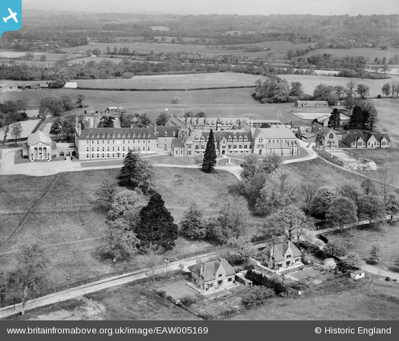
EAW005169 ENGLAND (1947). Cranleigh School, Cranleigh, from the south-east, 1947
© Copyright OpenStreetMap contributors and licensed by the OpenStreetMap Foundation. 2025. Cartography is licensed as CC BY-SA.
Nearby Images (14)
Details
| Title | [EAW005169] Cranleigh School, Cranleigh, from the south-east, 1947 |
| Reference | EAW005169 |
| Date | September-1947 |
| Link | |
| Place name | CRANLEIGH |
| Parish | CRANLEIGH |
| District | |
| Country | ENGLAND |
| Easting / Northing | 505491, 139951 |
| Longitude / Latitude | -0.49162508027895, 51.148562090272 |
| National Grid Reference | TQ055400 |
Pins
Be the first to add a comment to this image!


![[EAW005169] Cranleigh School, Cranleigh, from the south-east, 1947](http://britainfromabove.org.uk/sites/all/libraries/aerofilms-images/public/100x100/EAW/005/EAW005169.jpg)
![[EAW005171] Cranleigh School and Cranleigh Preparatory School, Cranleigh, 1947](http://britainfromabove.org.uk/sites/all/libraries/aerofilms-images/public/100x100/EAW/005/EAW005171.jpg)
![[EAW005164] Cranleigh School, Cranleigh, 1947](http://britainfromabove.org.uk/sites/all/libraries/aerofilms-images/public/100x100/EAW/005/EAW005164.jpg)
![[EAW005163] Cranleigh School, Cranleigh, 1947](http://britainfromabove.org.uk/sites/all/libraries/aerofilms-images/public/100x100/EAW/005/EAW005163.jpg)
![[EAW005167] Cranleigh School, Cranleigh, 1947](http://britainfromabove.org.uk/sites/all/libraries/aerofilms-images/public/100x100/EAW/005/EAW005167.jpg)
![[EAW005170] Cranleigh School, Cranleigh, 1947](http://britainfromabove.org.uk/sites/all/libraries/aerofilms-images/public/100x100/EAW/005/EAW005170.jpg)
![[EAW005165] Cranleigh School, Cranleigh, 1947](http://britainfromabove.org.uk/sites/all/libraries/aerofilms-images/public/100x100/EAW/005/EAW005165.jpg)
![[EAW005168] Cranleigh School, Cranleigh, 1947](http://britainfromabove.org.uk/sites/all/libraries/aerofilms-images/public/100x100/EAW/005/EAW005168.jpg)
![[EAW005161] Cranleigh Preparatory School, Cranleigh, 1947](http://britainfromabove.org.uk/sites/all/libraries/aerofilms-images/public/100x100/EAW/005/EAW005161.jpg)
![[EAW005162] Cranleigh Preparatory School, Cranleigh, 1947](http://britainfromabove.org.uk/sites/all/libraries/aerofilms-images/public/100x100/EAW/005/EAW005162.jpg)
![[EAW005159] Cranleigh Preparatory School, Cranleigh, 1947](http://britainfromabove.org.uk/sites/all/libraries/aerofilms-images/public/100x100/EAW/005/EAW005159.jpg)
![[EAW005160] Cranleigh Preparatory School, Cranleigh, 1947](http://britainfromabove.org.uk/sites/all/libraries/aerofilms-images/public/100x100/EAW/005/EAW005160.jpg)
![[EAW005172] Cranleigh School, Cranleigh, from the south, 1947](http://britainfromabove.org.uk/sites/all/libraries/aerofilms-images/public/100x100/EAW/005/EAW005172.jpg)
![[EAW005166] Cranleigh School, Cranleigh, 1947](http://britainfromabove.org.uk/sites/all/libraries/aerofilms-images/public/100x100/EAW/005/EAW005166.jpg)