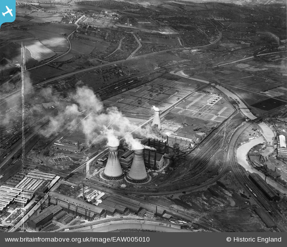
EAW005010 ENGLAND (1947). The Blackburn Meadows Power Station and Sewage Works, Tinsley, 1947. This image was marked by Aerofilms Ltd for photo editing.
© Copyright OpenStreetMap contributors and licensed by the OpenStreetMap Foundation. 2026. Cartography is licensed as CC BY-SA.
Nearby Images (7)
Details
| Title | [EAW005010] The Blackburn Meadows Power Station and Sewage Works, Tinsley, 1947. This image was marked by Aerofilms Ltd for photo editing. |
| Reference | EAW005010 |
| Date | 7-May-1947 |
| Link | |
| Place name | TINSLEY |
| Parish | |
| District | |
| Country | ENGLAND |
| Easting / Northing | 439827, 391747 |
| Longitude / Latitude | -1.4006414755001, 53.420757636099 |
| National Grid Reference | SK398917 |
Pins

JER |
Friday 10th of January 2014 05:17:47 PM | |

JER |
Friday 10th of January 2014 05:16:49 PM | |

JER |
Friday 10th of January 2014 05:16:19 PM | |

JER |
Friday 10th of January 2014 05:15:26 PM | |

JER |
Friday 10th of January 2014 05:11:29 PM | |

JER |
Friday 10th of January 2014 05:10:20 PM | |

JER |
Friday 10th of January 2014 05:09:01 PM | |

JER |
Friday 10th of January 2014 05:08:12 PM | |

JER |
Friday 10th of January 2014 05:07:43 PM | |

JER |
Friday 10th of January 2014 05:06:17 PM | |

JER |
Friday 10th of January 2014 05:04:44 PM | |

JER |
Friday 10th of January 2014 05:03:11 PM | |

JER |
Friday 10th of January 2014 05:02:05 PM |


![[EAW005010] The Blackburn Meadows Power Station and Sewage Works, Tinsley, 1947. This image was marked by Aerofilms Ltd for photo editing.](http://britainfromabove.org.uk/sites/all/libraries/aerofilms-images/public/100x100/EAW/005/EAW005010.jpg)
![[EAW005012] The Blackburn Meadows Power Station and Sewage Works, Tinsley, 1947](http://britainfromabove.org.uk/sites/all/libraries/aerofilms-images/public/100x100/EAW/005/EAW005012.jpg)
![[EAW005009] The Blackburn Meadows Power Station, Tinsley, 1947](http://britainfromabove.org.uk/sites/all/libraries/aerofilms-images/public/100x100/EAW/005/EAW005009.jpg)
![[EPW039004] Blackburn Meadows Power Station and the Sheffield Corporation Sewage Works, Tinsley, 1932](http://britainfromabove.org.uk/sites/all/libraries/aerofilms-images/public/100x100/EPW/039/EPW039004.jpg)
![[EPW039005] Blackburn Meadows Power Station and the Sheffield Corporation Sewage Works, Tinsley, 1932](http://britainfromabove.org.uk/sites/all/libraries/aerofilms-images/public/100x100/EPW/039/EPW039005.jpg)
![[EPW039001] Blackburn Meadows Power Station and the Sheffield Corporation Sewage Works, Tinsley, 1932](http://britainfromabove.org.uk/sites/all/libraries/aerofilms-images/public/100x100/EPW/039/EPW039001.jpg)
![[EPW039000] Blackburn Meadows Power Station and the Sheffield Corporation Sewage Works, Tinsley, 1932](http://britainfromabove.org.uk/sites/all/libraries/aerofilms-images/public/100x100/EPW/039/EPW039000.jpg)