
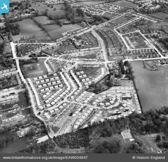
EAW004847 ENGLAND (1947). Prefabricated housing around Foster Avenue, Clewer Green, 1947
© Copyright OpenStreetMap contributors and licensed by the OpenStreetMap Foundation. 2026. Cartography is licensed as CC BY-SA.
Nearby Images (2)
EAW004847

EAW004848

Details
| Title | [EAW004847] Prefabricated housing around Foster Avenue, Clewer Green, 1947 |
| Reference | EAW004847 |
| Date | 29-April-1947 |
| Link | |
| Place name | CLEWER GREEN |
| Parish | |
| District | |
| Country | ENGLAND |
| Easting / Northing | 494309, 176008 |
| Longitude / Latitude | -0.64192378448266, 51.474677063029 |
| National Grid Reference | SU943760 |
Pins

Chris |
Sunday 24th of December 2023 01:47:13 PM | |
|
Chris |
Sunday 24th of December 2023 01:44:21 PM | |
|
Chris |
Sunday 24th of December 2023 01:42:31 PM | |
|
bondi |
Monday 22nd of February 2016 01:40:12 PM | |
|
bondi |
Monday 22nd of February 2016 01:40:09 PM |
User Comment Contributions
A very similar image, with a number of comments 'pinned' is here. http://www.britainfromabove.org.uk/image/eaw004848 |
Thamesweb |
Friday 22nd of August 2014 03:43:53 PM |