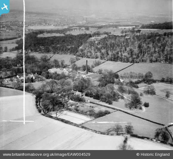
EAW004529 ENGLAND (1947). Hopton Woollen Mills and environs, Mirfield, from the south-west, 1947. This image was marked by Aerofilms Ltd for photo editing.
© Copyright OpenStreetMap contributors and licensed by the OpenStreetMap Foundation. 2025. Cartography is licensed as CC BY-SA.
Details
| Title | [EAW004529] Hopton Woollen Mills and environs, Mirfield, from the south-west, 1947. This image was marked by Aerofilms Ltd for photo editing. |
| Reference | EAW004529 |
| Date | 16-April-1947 |
| Link | |
| Place name | MIRFIELD |
| Parish | MIRFIELD |
| District | |
| Country | ENGLAND |
| Easting / Northing | 420979, 418362 |
| Longitude / Latitude | -1.6824939464749, 53.661093374177 |
| National Grid Reference | SE210184 |
Pins
Be the first to add a comment to this image!


![[EAW004529] Hopton Woollen Mills and environs, Mirfield, from the south-west, 1947. This image was marked by Aerofilms Ltd for photo editing.](http://britainfromabove.org.uk/sites/all/libraries/aerofilms-images/public/100x100/EAW/004/EAW004529.jpg)
![[EAW006215] Whitley Wood and Hopton Woollen Mills, Lower Hopton, 1947. This image was marked by Aerofilms Ltd for photo editing.](http://britainfromabove.org.uk/sites/all/libraries/aerofilms-images/public/100x100/EAW/006/EAW006215.jpg)
![[EAW006210] Hopton Woollen Mills, Lower Hopton, 1947](http://britainfromabove.org.uk/sites/all/libraries/aerofilms-images/public/100x100/EAW/006/EAW006210.jpg)
![[EAW004531] Hopton Woollen Mills, Mirfield, 1947. This image was marked by Aerofilms Ltd for photo editing.](http://britainfromabove.org.uk/sites/all/libraries/aerofilms-images/public/100x100/EAW/004/EAW004531.jpg)