
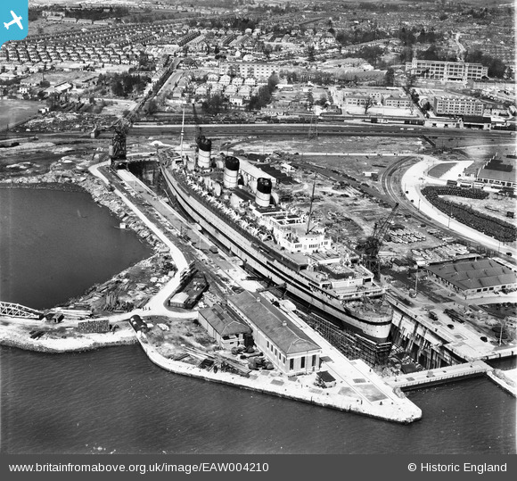
EAW004210 ENGLAND (1947). Queen Mary in dry dock, Southampton, 1947
© Copyright OpenStreetMap contributors and licensed by the OpenStreetMap Foundation. 2026. Cartography is licensed as CC BY-SA.
Nearby Images (19)
EAW004210

EAW001352

EAW001351

EAW004211

EPW043735

EPW043733

EPW043727

EAW051307

EPW043734

EPW043736

EAW051310

EAW229813

EPW043729

EAW051308

EAW035807

EAW051309

EPW042951

EPW043726

EAW035806

Details
| Title | [EAW004210] Queen Mary in dry dock, Southampton, 1947 |
| Reference | EAW004210 |
| Date | 10-April-1947 |
| Link | |
| Place name | SOUTHAMPTON |
| Parish | |
| District | |
| Country | ENGLAND |
| Easting / Northing | 439329, 112368 |
| Longitude / Latitude | -1.4405545217033, 50.90888775768 |
| National Grid Reference | SU393124 |
Pins

Matt Aldred edob.mattaldred.com |
Sunday 12th of July 2026 08:00:59 PM | |

M |
Thursday 22nd of August 2024 11:19:49 AM | |
|
M |
Thursday 22nd of August 2024 11:18:30 AM | |
|
redmist |
Tuesday 6th of December 2022 08:39:54 PM | |
|
Kentishman |
Sunday 21st of March 2021 09:33:23 AM | |
|
Kentishman |
Sunday 21st of March 2021 09:29:30 AM | |
|
Kentishman |
Friday 5th of March 2021 07:21:00 AM | |
See also https://commons.wikimedia.org/wiki/Category:Naval_mines_of_the_United_Kingdom |
Kentishman |
Friday 5th of March 2021 07:39:39 AM |
|
ken |
Sunday 19th of July 2015 01:09:00 PM | |
|
ken |
Sunday 19th of July 2015 01:08:17 PM | |

Maurice |
Wednesday 28th of August 2013 08:28:45 AM | |
|
Maurice |
Wednesday 28th of August 2013 08:26:51 AM | |
Katy Whitaker |
Tuesday 27th of August 2013 11:18:53 PM | |
I suspect they are floats, like large glass fishing net floats. These would have carried anti-submarine nets in or around the Solent area. Just a guess! |
Maurice |
Wednesday 28th of August 2013 08:22:15 AM |