
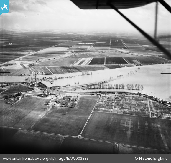
EAW003833 ENGLAND (1947). Flooding of the River Great Ouse near Littleport Railway Station, Littleport, from the west, 1947
© Copyright OpenStreetMap contributors and licensed by the OpenStreetMap Foundation. 2026. Cartography is licensed as CC BY-SA.
Details
| Title | [EAW003833] Flooding of the River Great Ouse near Littleport Railway Station, Littleport, from the west, 1947 |
| Reference | EAW003833 |
| Date | March-1947 |
| Link | |
| Place name | LITTLEPORT |
| Parish | LITTLEPORT |
| District | |
| Country | ENGLAND |
| Easting / Northing | 557278, 287296 |
| Longitude / Latitude | 0.31520928294903, 52.46055694847 |
| National Grid Reference | TL573873 |
Pins

Matt Aldred edob.mattaldred.com |
Tuesday 7th of July 2026 04:59:49 PM | |
|
Matt Aldred edob.mattaldred.com |
Thursday 19th of June 2025 12:02:20 PM | |
|
Matt Aldred edob.mattaldred.com |
Monday 8th of March 2021 08:33:24 PM | |
|
Matt Aldred edob.mattaldred.com |
Monday 8th of March 2021 08:27:40 PM | |
|
Matt Aldred edob.mattaldred.com |
Monday 2nd of September 2019 03:14:51 PM | |

jrussill |
Friday 24th of July 2015 12:38:49 PM |
User Comment Contributions
WW2 Pillbox |
jrussill |
Friday 24th of July 2015 12:42:26 PM |