
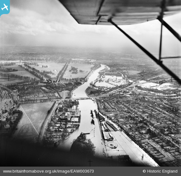
EAW003673 ENGLAND (1947). Hampton Court Palace alongside the River Thames in flood, East Molesey, from the north-west, 1947
© Copyright OpenStreetMap contributors and licensed by the OpenStreetMap Foundation. 2026. Cartography is licensed as CC BY-SA.
Nearby Images (4)
EAW003673

EPW022850

EPW049593

EAW022050

Details
| Title | [EAW003673] Hampton Court Palace alongside the River Thames in flood, East Molesey, from the north-west, 1947 |
| Reference | EAW003673 |
| Date | 18-March-1947 |
| Link | |
| Place name | EAST MOLESEY |
| Parish | |
| District | |
| Country | ENGLAND |
| Easting / Northing | 515098, 168667 |
| Longitude / Latitude | -0.34506580421904, 51.404841931635 |
| National Grid Reference | TQ151687 |
Pins

Matt Aldred edob.mattaldred.com |
Friday 27th of September 2024 06:57:48 PM | |
|
Matt Aldred edob.mattaldred.com |
Friday 27th of September 2024 06:57:30 PM | |

Nowy Paul |
Sunday 5th of November 2017 04:35:57 PM | |
|
Nowy Paul |
Sunday 5th of November 2017 04:30:38 PM | |
|
nigs |
Wednesday 29th of October 2014 07:25:19 PM | |
|
nigs |
Wednesday 29th of October 2014 07:21:34 PM | |
|
nigs |
Wednesday 29th of October 2014 07:19:23 PM | |
|
nigs |
Wednesday 29th of October 2014 07:17:25 PM |
User Comment Contributions
Hampton Court Palace |

Alan McFaden |
Thursday 20th of November 2014 09:02:06 PM |