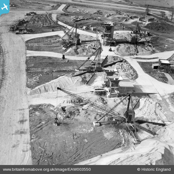
EAW003550 ENGLAND (1947). Construction machinery at Bristol Filton Airport, Catbrain, 1947
© Copyright OpenStreetMap contributors and licensed by the OpenStreetMap Foundation. 2026. Cartography is licensed as CC BY-SA.
Nearby Images (30)
Details
| Title | [EAW003550] Construction machinery at Bristol Filton Airport, Catbrain, 1947 |
| Reference | EAW003550 |
| Date | 3-March-1947 |
| Link | |
| Place name | CATBRAIN |
| Parish | ALMONDSBURY |
| District | |
| Country | ENGLAND |
| Easting / Northing | 359262, 180411 |
| Longitude / Latitude | -2.5872194026982, 51.520665289221 |
| National Grid Reference | ST593804 |
Pins
Be the first to add a comment to this image!


![[EAW003550] Construction machinery at Bristol Filton Airport, Catbrain, 1947](http://britainfromabove.org.uk/sites/all/libraries/aerofilms-images/public/100x100/EAW/003/EAW003550.jpg)
![[EAW003558] Construction machinery at Bristol Filton Airport, Catbrain, 1947](http://britainfromabove.org.uk/sites/all/libraries/aerofilms-images/public/100x100/EAW/003/EAW003558.jpg)
![[EAW003551] Construction machinery at Bristol Filton Airport, Catbrain, 1947](http://britainfromabove.org.uk/sites/all/libraries/aerofilms-images/public/100x100/EAW/003/EAW003551.jpg)
![[EAW003552] Construction machinery at Bristol Filton Airport, Catbrain, 1947](http://britainfromabove.org.uk/sites/all/libraries/aerofilms-images/public/100x100/EAW/003/EAW003552.jpg)
![[EAW004192] Cranes handling aggregates during building works at Bristol Filton Airport, Catbrain, 1947](http://britainfromabove.org.uk/sites/all/libraries/aerofilms-images/public/100x100/EAW/004/EAW004192.jpg)
![[EAW007150] Cranes handling aggregates during building works at Bristol Filton Airport, Catbrain, 1947](http://britainfromabove.org.uk/sites/all/libraries/aerofilms-images/public/100x100/EAW/007/EAW007150.jpg)
![[EAW004193] Cranes handling aggregates during building works at Bristol Filton Airport, Catbrain, from the east, 1947](http://britainfromabove.org.uk/sites/all/libraries/aerofilms-images/public/100x100/EAW/004/EAW004193.jpg)
![[EAW007129] Cranes handling aggregates during building works at Bristol Filton Airport, Catbrain, 1947](http://britainfromabove.org.uk/sites/all/libraries/aerofilms-images/public/100x100/EAW/007/EAW007129.jpg)
![[EAW007132] Cranes handling aggregates during building works at Bristol Filton Airport, Catbrain, 1947](http://britainfromabove.org.uk/sites/all/libraries/aerofilms-images/public/100x100/EAW/007/EAW007132.jpg)
![[EAW007130] Cranes handling aggregates during building works at Bristol Filton Airport, Catbrain, 1947](http://britainfromabove.org.uk/sites/all/libraries/aerofilms-images/public/100x100/EAW/007/EAW007130.jpg)
![[EAW004191] Cranes handling aggregates during building works at Bristol Filton Airport, Catbrain, 1947](http://britainfromabove.org.uk/sites/all/libraries/aerofilms-images/public/100x100/EAW/004/EAW004191.jpg)
![[EAW007141] Cranes handling aggregates during building works at Bristol Filton Airport, Catbrain, 1947](http://britainfromabove.org.uk/sites/all/libraries/aerofilms-images/public/100x100/EAW/007/EAW007141.jpg)
![[EAW007148] Cranes handling aggregates during building works at Bristol Filton Airport, Catbrain, 1947](http://britainfromabove.org.uk/sites/all/libraries/aerofilms-images/public/100x100/EAW/007/EAW007148.jpg)
![[EAW007134] Cranes handling aggregates during building works at Bristol Filton Airport, Catbrain, 1947](http://britainfromabove.org.uk/sites/all/libraries/aerofilms-images/public/100x100/EAW/007/EAW007134.jpg)
![[EAW004188] Cranes handling aggregates during building works at Bristol Filton Airport, Catbrain, 1947](http://britainfromabove.org.uk/sites/all/libraries/aerofilms-images/public/100x100/EAW/004/EAW004188.jpg)
![[EAW004189] Cranes handling aggregates during building works at Bristol Filton Airport, Catbrain, from the south-west, 1947](http://britainfromabove.org.uk/sites/all/libraries/aerofilms-images/public/100x100/EAW/004/EAW004189.jpg)
![[EAW007139] Cranes handling aggregates during building works at Bristol Filton Airport, Catbrain, 1947](http://britainfromabove.org.uk/sites/all/libraries/aerofilms-images/public/100x100/EAW/007/EAW007139.jpg)
![[EAW007147] Cranes handling aggregates during building works at Bristol Filton Airport, Catbrain, 1947](http://britainfromabove.org.uk/sites/all/libraries/aerofilms-images/public/100x100/EAW/007/EAW007147.jpg)
![[EAW009936] Bristol Filton Airport under construction, Catbrain, 1947](http://britainfromabove.org.uk/sites/all/libraries/aerofilms-images/public/100x100/EAW/009/EAW009936.jpg)
![[EAW004185] Cranes handling aggregates during building works at Bristol Filton Airport, Catbrain, 1947](http://britainfromabove.org.uk/sites/all/libraries/aerofilms-images/public/100x100/EAW/004/EAW004185.jpg)
![[EAW007149] Cranes handling aggregates during building works at Bristol Filton Airport, Catbrain, 1947](http://britainfromabove.org.uk/sites/all/libraries/aerofilms-images/public/100x100/EAW/007/EAW007149.jpg)
![[EAW009946] Bristol Filton Airport under construction, Catbrain, 1947](http://britainfromabove.org.uk/sites/all/libraries/aerofilms-images/public/100x100/EAW/009/EAW009946.jpg)
![[EAW007142] The main runway under construction at Bristol Filton Airport, Catbrain, 1947](http://britainfromabove.org.uk/sites/all/libraries/aerofilms-images/public/100x100/EAW/007/EAW007142.jpg)
![[EAW009935] Bristol Filton Airport under construction, Catbrain, from the west, 1947](http://britainfromabove.org.uk/sites/all/libraries/aerofilms-images/public/100x100/EAW/009/EAW009935.jpg)
![[EAW009947] Bristol Filton Airport under construction, Catbrain, 1947](http://britainfromabove.org.uk/sites/all/libraries/aerofilms-images/public/100x100/EAW/009/EAW009947.jpg)
![[EAW007140] The main runway under construction at Bristol Filton Airport, Catbrain, 1947](http://britainfromabove.org.uk/sites/all/libraries/aerofilms-images/public/100x100/EAW/007/EAW007140.jpg)
![[EAW012431] Bristol Filton Airport under construction, Catbrain, from the east, 1947](http://britainfromabove.org.uk/sites/all/libraries/aerofilms-images/public/100x100/EAW/012/EAW012431.jpg)
![[EAW009958] Bristol Filton Airport under construction, Patchway, 1947](http://britainfromabove.org.uk/sites/all/libraries/aerofilms-images/public/100x100/EAW/009/EAW009958.jpg)
![[EAW004187] The main runway of Bristol Filton Airport under construction, Catbrain, 1947](http://britainfromabove.org.uk/sites/all/libraries/aerofilms-images/public/100x100/EAW/004/EAW004187.jpg)
![[EAW004190] The main runway of Bristol Filton Airport under construction, Catbrain, 1947](http://britainfromabove.org.uk/sites/all/libraries/aerofilms-images/public/100x100/EAW/004/EAW004190.jpg)