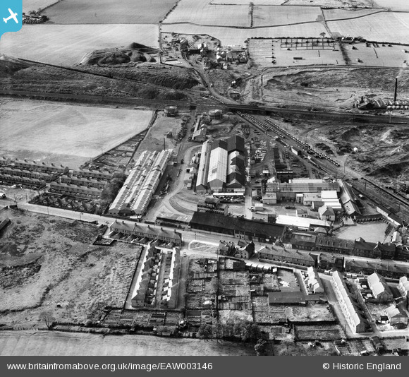
EAW003146 ENGLAND (1946). The Birtley Iron Co Ltd Works and Ouston Colliery, Birtley, 1946
© Copyright OpenStreetMap contributors and licensed by the OpenStreetMap Foundation. 2026. Cartography is licensed as CC BY-SA.
Nearby Images (13)
Details
| Title | [EAW003146] The Birtley Iron Co Ltd Works and Ouston Colliery, Birtley, 1946 |
| Reference | EAW003146 |
| Date | 23-October-1946 |
| Link | |
| Place name | BIRTLEY |
| Parish | |
| District | |
| Country | ENGLAND |
| Easting / Northing | 427149, 555098 |
| Longitude / Latitude | -1.5767052042805, 54.889800824363 |
| National Grid Reference | NZ271551 |
Pins

redmist |
Thursday 31st of October 2019 10:44:20 PM | |

redmist |
Thursday 31st of October 2019 10:43:50 PM | |

redmist |
Thursday 31st of October 2019 10:41:36 PM | |

Sparky |
Friday 15th of September 2017 09:28:40 AM | |

Sparky |
Friday 15th of September 2017 09:27:38 AM |


![[EAW003146] The Birtley Iron Co Ltd Works and Ouston Colliery, Birtley, 1946](http://britainfromabove.org.uk/sites/all/libraries/aerofilms-images/public/100x100/EAW/003/EAW003146.jpg)
![[EAW003139] The Birtley Iron Co Ltd Works and the surrounding area, Birtley, from the east, 1946](http://britainfromabove.org.uk/sites/all/libraries/aerofilms-images/public/100x100/EAW/003/EAW003139.jpg)
![[EAW003149] The Birtley Iron Co Ltd Works and the surrounding countryside, Birtley, from the east, 1946](http://britainfromabove.org.uk/sites/all/libraries/aerofilms-images/public/100x100/EAW/003/EAW003149.jpg)
![[EAW003144] The Birtley Iron Co Ltd Works, the Ouston Colliery and the surrounding countryside, Birtley, from the north-east, 1946](http://britainfromabove.org.uk/sites/all/libraries/aerofilms-images/public/100x100/EAW/003/EAW003144.jpg)
![[EAW003140] The Birtley Iron Co Ltd Works and the surrounding area, Birtley, from the south-east, 1946](http://britainfromabove.org.uk/sites/all/libraries/aerofilms-images/public/100x100/EAW/003/EAW003140.jpg)
![[EAW003147] The Birtley Iron Co Ltd Works and Ouston Colliery, Birtley, from the north-east, 1946](http://britainfromabove.org.uk/sites/all/libraries/aerofilms-images/public/100x100/EAW/003/EAW003147.jpg)
![[EAW003145] The Birtley Iron Co Ltd Works, Birtley, 1946](http://britainfromabove.org.uk/sites/all/libraries/aerofilms-images/public/100x100/EAW/003/EAW003145.jpg)
![[EAW003143] The Birtley Iron Co Ltd Works, Birtley, 1946](http://britainfromabove.org.uk/sites/all/libraries/aerofilms-images/public/100x100/EAW/003/EAW003143.jpg)
![[EAW003141] The Birtley Iron Co Ltd Works, Birtley, 1946. This image has been affected by flare.](http://britainfromabove.org.uk/sites/all/libraries/aerofilms-images/public/100x100/EAW/003/EAW003141.jpg)
![[EAW003148] The Birtley Iron Co Ltd Works and the surrounding countryside, Birtley, from the west, 1946](http://britainfromabove.org.uk/sites/all/libraries/aerofilms-images/public/100x100/EAW/003/EAW003148.jpg)
![[EAW003142] The Birtley Iron Co Ltd Works and the town, Birtley, from the south-west, 1946](http://britainfromabove.org.uk/sites/all/libraries/aerofilms-images/public/100x100/EAW/003/EAW003142.jpg)
![[EAW003138] The Birtley Iron Co Ltd Works and the surrounding area, Birtley, from the north-west, 1946](http://britainfromabove.org.uk/sites/all/libraries/aerofilms-images/public/100x100/EAW/003/EAW003138.jpg)
![[EAW003136] The Birtley Iron Co Ltd Works and the surrounding industrial area, Birtley, 1946](http://britainfromabove.org.uk/sites/all/libraries/aerofilms-images/public/100x100/EAW/003/EAW003136.jpg)