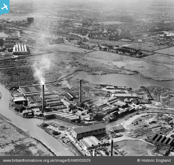
EAW003029 ENGLAND (1946). Johnson & Sons Ltd Smelting Works (Creek Works) and environs, Brimsdown, 1946
© Copyright OpenStreetMap contributors and licensed by the OpenStreetMap Foundation. 2026. Cartography is licensed as CC BY-SA.
Nearby Images (19)
Details
| Title | [EAW003029] Johnson & Sons Ltd Smelting Works (Creek Works) and environs, Brimsdown, 1946 |
| Reference | EAW003029 |
| Date | 10-October-1946 |
| Link | |
| Place name | BRIMSDOWN |
| Parish | |
| District | |
| Country | ENGLAND |
| Easting / Northing | 536792, 196528 |
| Longitude / Latitude | -0.022500193766739, 51.650414613488 |
| National Grid Reference | TQ368965 |
Pins

Matt Aldred edob.mattaldred.com |
Saturday 15th of May 2021 10:19:27 PM | |

Matt Aldred edob.mattaldred.com |
Saturday 15th of May 2021 10:19:12 PM | |

Matt Aldred edob.mattaldred.com |
Saturday 15th of May 2021 10:18:50 PM | |

Matt Aldred edob.mattaldred.com |
Saturday 15th of May 2021 10:18:14 PM | |

Matt Aldred edob.mattaldred.com |
Saturday 15th of May 2021 10:17:55 PM | |

Matt Aldred edob.mattaldred.com |
Saturday 15th of May 2021 10:17:31 PM | |

Ray Flack |
Monday 15th of September 2014 11:38:12 AM | |

Ray Flack |
Monday 15th of September 2014 11:31:14 AM | |

Ray Flack |
Monday 15th of September 2014 11:24:21 AM | |

Ray Flack |
Monday 15th of September 2014 11:23:21 AM | |

Ray Flack |
Monday 15th of September 2014 11:19:18 AM | |

Ray Flack |
Monday 15th of September 2014 11:15:53 AM | |

Ray Flack |
Monday 15th of September 2014 11:14:49 AM | |

Ray Flack |
Monday 15th of September 2014 10:47:01 AM | |

Ray Flack |
Friday 22nd of November 2013 10:24:35 AM | |

Ray Flack |
Sunday 10th of November 2013 03:53:53 PM | |

Ray Flack |
Sunday 10th of November 2013 01:14:23 PM | |

Ray Flack |
Sunday 10th of November 2013 01:10:52 PM | |

JackieB |
Sunday 13th of October 2013 01:04:23 PM | |

JackieB |
Sunday 13th of October 2013 01:03:33 PM | |

JackieB |
Sunday 13th of October 2013 01:03:00 PM | |

JackieB |
Sunday 13th of October 2013 01:02:21 PM | |

JackieB |
Sunday 13th of October 2013 01:01:51 PM | |

JackieB |
Sunday 13th of October 2013 01:01:12 PM | |

JackieB |
Sunday 13th of October 2013 01:00:16 PM | |

JackieB |
Sunday 13th of October 2013 12:59:33 PM | |

JackieB |
Sunday 13th of October 2013 12:59:03 PM | |

JackieB |
Sunday 13th of October 2013 12:58:06 PM | |

JackieB |
Sunday 13th of October 2013 12:57:24 PM |


![[EAW003029] Johnson & Sons Ltd Smelting Works (Creek Works) and environs, Brimsdown, 1946](http://britainfromabove.org.uk/sites/all/libraries/aerofilms-images/public/100x100/EAW/003/EAW003029.jpg)
![[EAW003030] Johnson & Sons Ltd Smelting Works (Creek Works) and environs, Brimsdown, 1946](http://britainfromabove.org.uk/sites/all/libraries/aerofilms-images/public/100x100/EAW/003/EAW003030.jpg)
![[EAW003025] Johnson & Sons Ltd Smelting Works (Creek Works), Brimsdown, 1946](http://britainfromabove.org.uk/sites/all/libraries/aerofilms-images/public/100x100/EAW/003/EAW003025.jpg)
![[EAW003032] Johnson & Sons Ltd Smelting Works (Creek Works) on the River Lea and environs, Brimsdown, 1946](http://britainfromabove.org.uk/sites/all/libraries/aerofilms-images/public/100x100/EAW/003/EAW003032.jpg)
![[EAW003026] Johnson & Sons Ltd Smelting Works (Creek Works) on the River Lea and environs, Brimsdown, from the north, 1946](http://britainfromabove.org.uk/sites/all/libraries/aerofilms-images/public/100x100/EAW/003/EAW003026.jpg)
![[EAW003031] Industry along the the River Lea including the Johnson & Sons Ltd Smelting Works (Creek Works), Brimsdown, 1946](http://britainfromabove.org.uk/sites/all/libraries/aerofilms-images/public/100x100/EAW/003/EAW003031.jpg)
![[EAW003022] Industry along the the River Lea including the Johnson & Sons Ltd Smelting Works (Creek Works), Brimsdown, 1946](http://britainfromabove.org.uk/sites/all/libraries/aerofilms-images/public/100x100/EAW/003/EAW003022.jpg)
![[EPW060853] Smelting Works and the Ruberoid Works taken to test new Kodak Panchromatic glass plates, Brimsdown, 1939](http://britainfromabove.org.uk/sites/all/libraries/aerofilms-images/public/100x100/EPW/060/EPW060853.jpg)
![[EAW003023] Johnson & Sons Ltd Smelting Works (Creek Works) on the River Lea and environs, Brimsdown, 1946](http://britainfromabove.org.uk/sites/all/libraries/aerofilms-images/public/100x100/EAW/003/EAW003023.jpg)
![[EAW003028] Johnson & Sons Ltd Smelting Works (Creek Works) on the River Lea and King George's Reservoir, Brimsdown, 1946](http://britainfromabove.org.uk/sites/all/libraries/aerofilms-images/public/100x100/EAW/003/EAW003028.jpg)
![[EAW003027] Johnson & Sons Ltd Smelting Works (Creek Works) on the River Lea and environs, Brimsdown, from the east, 1946](http://britainfromabove.org.uk/sites/all/libraries/aerofilms-images/public/100x100/EAW/003/EAW003027.jpg)
![[EAW003024] Johnson & Sons Ltd Smelting Works (Creek Works) on the River Lea and environs, Brimsdown, 1946](http://britainfromabove.org.uk/sites/all/libraries/aerofilms-images/public/100x100/EAW/003/EAW003024.jpg)
![[EAW003033] Industry along the the River Lea including the Johnson & Sons Ltd Smelting Works (Creek Works), Brimsdown, from the south, 1946](http://britainfromabove.org.uk/sites/all/libraries/aerofilms-images/public/100x100/EAW/003/EAW003033.jpg)
![[EPW046480] The Ruberoid Co Works next to the River Lea, Brimsdown, 1935](http://britainfromabove.org.uk/sites/all/libraries/aerofilms-images/public/100x100/EPW/046/EPW046480.jpg)
![[EPW046483] The Ruberoid Co Works, the Enfield Cable Works and environs, Brimsdown, 1935](http://britainfromabove.org.uk/sites/all/libraries/aerofilms-images/public/100x100/EPW/046/EPW046483.jpg)
![[EAW003021] Johnson & Sons Ltd Smelting Works (Creek Works) on the River Lea and environs, Brimsdown, 1946](http://britainfromabove.org.uk/sites/all/libraries/aerofilms-images/public/100x100/EAW/003/EAW003021.jpg)
![[EAW004480] Brimsdown Industrial Estate, King George's Reservoir and environs, Brimsdown, from the south, 1947](http://britainfromabove.org.uk/sites/all/libraries/aerofilms-images/public/100x100/EAW/004/EAW004480.jpg)
![[EPW046481] The Ruberoid Co Works next to the River Lea, Brimsdown, 1935](http://britainfromabove.org.uk/sites/all/libraries/aerofilms-images/public/100x100/EPW/046/EPW046481.jpg)
![[EPW046484] The Ruberoid Co Works on the River Lea and environs, Brimsdown, 1935](http://britainfromabove.org.uk/sites/all/libraries/aerofilms-images/public/100x100/EPW/046/EPW046484.jpg)


