
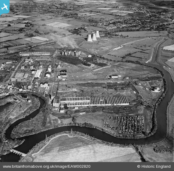
EAW002820 ENGLAND (1946). The British Celanese Synthetic Fibres Works and the River Derwent, Spondon, 1946
© Copyright OpenStreetMap contributors and licensed by the OpenStreetMap Foundation. 2026. Cartography is licensed as CC BY-SA.
Nearby Images (5)
EAW002820

EAW000368

EAW000922

EPW046132

EAW000360

Details
| Title | [EAW002820] The British Celanese Synthetic Fibres Works and the River Derwent, Spondon, 1946 |
| Reference | EAW002820 |
| Date | 27-September-1946 |
| Link | |
| Place name | SPONDON |
| Parish | |
| District | |
| Country | ENGLAND |
| Easting / Northing | 440103, 334182 |
| Longitude / Latitude | -1.403703690979, 52.903257353639 |
| National Grid Reference | SK401342 |
Pins

Triggy |
Monday 10th of February 2014 11:50:57 AM | |
|
Triggy |
Monday 10th of February 2014 11:50:19 AM | |
|
Triggy |
Monday 10th of February 2014 11:49:10 AM | |
|
Triggy |
Sunday 9th of February 2014 09:38:36 PM | |
|
Triggy |
Sunday 9th of February 2014 09:37:00 PM | |
|
Triggy |
Sunday 9th of February 2014 09:31:33 PM | |
|
Triggy |
Sunday 9th of February 2014 09:30:19 PM | |
|
JoSpr |
Thursday 9th of January 2014 11:04:24 PM | |
|
JoSpr |
Thursday 9th of January 2014 10:59:27 PM | |
|
JoSpr |
Thursday 9th of January 2014 10:54:05 PM | |
|
JoSpr |
Thursday 9th of January 2014 10:50:03 PM | |
|
JoSpr |
Thursday 9th of January 2014 10:45:13 PM | |
|
JoSpr |
Thursday 9th of January 2014 10:33:14 PM | |
|
JoSpr |
Thursday 9th of January 2014 10:28:55 PM | |
|
JoSpr |
Wednesday 8th of January 2014 02:28:27 AM | |
|
JoSpr |
Wednesday 8th of January 2014 02:20:51 AM | |
|
JoSpr |
Wednesday 8th of January 2014 02:08:07 AM | |
|
JoSpr |
Wednesday 8th of January 2014 02:05:19 AM | |
|
JoSpr |
Wednesday 8th of January 2014 01:56:08 AM | |
|
JoSpr |
Wednesday 8th of January 2014 01:51:40 AM | |
|
JoSpr |
Wednesday 8th of January 2014 01:44:34 AM | |
|
JoSpr |
Wednesday 8th of January 2014 01:37:52 AM | |
|
JoSpr |
Wednesday 8th of January 2014 01:36:09 AM | |
|
JoSpr |
Wednesday 8th of January 2014 01:34:02 AM | |
|
JoSpr |
Wednesday 8th of January 2014 01:10:11 AM | |
|
JoSpr |
Wednesday 8th of January 2014 01:08:20 AM | |
|
JoSpr |
Wednesday 8th of January 2014 01:05:28 AM | |
The foundations of the bypass were built in the 1930s and the bypass completed and opened in the mid 1950s |
JoSpr |
Wednesday 8th of January 2014 01:19:16 AM |
|
JoSpr |
Wednesday 8th of January 2014 01:04:08 AM | |

Peter Kazmierczak |
Friday 13th of September 2013 11:24:50 PM |
User Comment Contributions
This image includes the village of Borrowash, much of the village of Ockbrook, and Spondon Power Station. If the image is magnified twice and moved down, then Cole Lane and Gypsy Lane can be seen clearly, as can the fringes of Hopwell Hall. |
JoSpr |
Wednesday 8th of January 2014 02:36:28 AM |