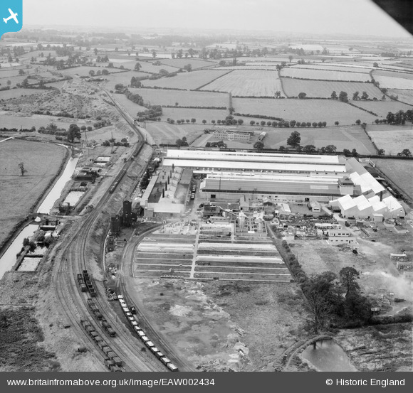
EAW002434 ENGLAND (1946). The Northern Aluminium Co Works and environs, Banbury, from the east, 1946
© Copyright OpenStreetMap contributors and licensed by the OpenStreetMap Foundation. 2026. Cartography is licensed as CC BY-SA.
Nearby Images (13)
Details
| Title | [EAW002434] The Northern Aluminium Co Works and environs, Banbury, from the east, 1946 |
| Reference | EAW002434 |
| Date | 2-September-1946 |
| Link | |
| Place name | BANBURY |
| Parish | BANBURY |
| District | |
| Country | ENGLAND |
| Easting / Northing | 445958, 242669 |
| Longitude / Latitude | -1.3292864279808, 52.080053473913 |
| National Grid Reference | SP460427 |
Pins

Matt Aldred edob.mattaldred.com |
Sunday 2nd of March 2025 07:26:47 PM | |

Matt Aldred edob.mattaldred.com |
Sunday 2nd of March 2025 07:26:28 PM | |

redmist |
Tuesday 11th of October 2022 07:49:50 PM | |

redmist |
Tuesday 11th of October 2022 07:48:49 PM | |

redmist |
Tuesday 11th of October 2022 07:48:09 PM | |

Ged |
Sunday 6th of March 2022 04:55:13 PM | |

John W |
Sunday 21st of August 2016 05:41:49 PM | |

John W |
Sunday 21st of August 2016 05:41:11 PM |


![[EAW002434] The Northern Aluminium Co Works and environs, Banbury, from the east, 1946](http://britainfromabove.org.uk/sites/all/libraries/aerofilms-images/public/100x100/EAW/002/EAW002434.jpg)
![[EPW049506] The Northern Aluminium Company Ltd Works, Banbury, 1935](http://britainfromabove.org.uk/sites/all/libraries/aerofilms-images/public/100x100/EPW/049/EPW049506.jpg)
![[EAW002437] The Northern Aluminium Co Works and environs, Banbury, 1946](http://britainfromabove.org.uk/sites/all/libraries/aerofilms-images/public/100x100/EAW/002/EAW002437.jpg)
![[EPW049504] The Northern Aluminium Company Ltd Works, Banbury, 1935](http://britainfromabove.org.uk/sites/all/libraries/aerofilms-images/public/100x100/EPW/049/EPW049504.jpg)
![[EPW049502] The Northern Aluminium Company Ltd Works, Banbury, 1935](http://britainfromabove.org.uk/sites/all/libraries/aerofilms-images/public/100x100/EPW/049/EPW049502.jpg)
![[EPW049503] The Northern Aluminium Company Ltd Works, Banbury, 1935](http://britainfromabove.org.uk/sites/all/libraries/aerofilms-images/public/100x100/EPW/049/EPW049503.jpg)
![[EPW049499] The Northern Aluminium Company Ltd Works, Banbury, 1935](http://britainfromabove.org.uk/sites/all/libraries/aerofilms-images/public/100x100/EPW/049/EPW049499.jpg)
![[EAW002431] The Northern Aluminium Co Works, Banbury, 1946](http://britainfromabove.org.uk/sites/all/libraries/aerofilms-images/public/100x100/EAW/002/EAW002431.jpg)
![[EPW049505] The Northern Aluminium Company Ltd Works, Banbury, 1935](http://britainfromabove.org.uk/sites/all/libraries/aerofilms-images/public/100x100/EPW/049/EPW049505.jpg)
![[EPW049507] The Northern Aluminium Company Ltd Works, Banbury, 1935](http://britainfromabove.org.uk/sites/all/libraries/aerofilms-images/public/100x100/EPW/049/EPW049507.jpg)
![[EPW049500] The Northern Aluminium Company Ltd Works, Banbury, 1935](http://britainfromabove.org.uk/sites/all/libraries/aerofilms-images/public/100x100/EPW/049/EPW049500.jpg)
![[EPW049501] The Northern Aluminium Company Ltd Works, Banbury, 1935](http://britainfromabove.org.uk/sites/all/libraries/aerofilms-images/public/100x100/EPW/049/EPW049501.jpg)
![[EAW002432] The Northern Aluminium Co Works and environs, Banbury, from the south, 1946](http://britainfromabove.org.uk/sites/all/libraries/aerofilms-images/public/100x100/EAW/002/EAW002432.jpg)