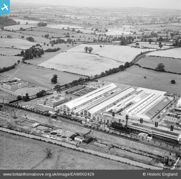
EAW002429 ENGLAND (1946). The Northern Aluminium Co Works and environs, Banbury, 1946
© Copyright OpenStreetMap contributors and licensed by the OpenStreetMap Foundation. 2026. Cartography is licensed as CC BY-SA.
Nearby Images (18)
Details
| Title | [EAW002429] The Northern Aluminium Co Works and environs, Banbury, 1946 |
| Reference | EAW002429 |
| Date | 2-September-1946 |
| Link | |
| Place name | BANBURY |
| Parish | BANBURY |
| District | |
| Country | ENGLAND |
| Easting / Northing | 445589, 242759 |
| Longitude / Latitude | -1.3346592077545, 52.080893180862 |
| National Grid Reference | SP456428 |
Pins

Matt Aldred edob.mattaldred.com |
Sunday 2nd of March 2025 07:25:22 PM | |

Ged |
Wednesday 30th of March 2022 05:39:58 PM | |

Ged |
Wednesday 16th of February 2022 10:31:58 PM | |

Starman |
Monday 23rd of March 2020 07:29:27 PM | |

Starman |
Monday 23rd of March 2020 07:28:15 PM | |

Starman |
Monday 23rd of March 2020 07:26:52 PM | |

Starman |
Monday 23rd of March 2020 07:25:08 PM | |

Starman |
Monday 23rd of March 2020 07:23:43 PM | |

Sparky |
Sunday 17th of September 2017 04:01:45 PM | |
Would you be kind enough to tell us more about this camouflage scheme, Starman? |

Nick Pigott |
Sunday 27th of June 2021 12:57:05 PM |

Sparky |
Sunday 17th of September 2017 04:00:56 PM | |

John W |
Sunday 21st of August 2016 05:36:22 PM | |

John W |
Sunday 21st of August 2016 05:32:19 PM |


![[EAW002429] The Northern Aluminium Co Works and environs, Banbury, 1946](http://britainfromabove.org.uk/sites/all/libraries/aerofilms-images/public/100x100/EAW/002/EAW002429.jpg)
![[EAW002436] The Northern Aluminium Co Works and environs, Banbury, from the north-west, 1946](http://britainfromabove.org.uk/sites/all/libraries/aerofilms-images/public/100x100/EAW/002/EAW002436.jpg)
![[EAW002435] The Northern Aluminium Co Works, Banbury, 1946](http://britainfromabove.org.uk/sites/all/libraries/aerofilms-images/public/100x100/EAW/002/EAW002435.jpg)
![[EAW002430] The Northern Aluminium Co Works and Hardwick Farm, Banbury, 1946](http://britainfromabove.org.uk/sites/all/libraries/aerofilms-images/public/100x100/EAW/002/EAW002430.jpg)
![[EAW002438] The Northern Aluminium Co Works and environs, Banbury, 1946](http://britainfromabove.org.uk/sites/all/libraries/aerofilms-images/public/100x100/EAW/002/EAW002438.jpg)
![[EAW002433] The Northern Aluminium Co Works and environs, Banbury, from the west, 1946](http://britainfromabove.org.uk/sites/all/libraries/aerofilms-images/public/100x100/EAW/002/EAW002433.jpg)
![[EPW049501] The Northern Aluminium Company Ltd Works, Banbury, 1935](http://britainfromabove.org.uk/sites/all/libraries/aerofilms-images/public/100x100/EPW/049/EPW049501.jpg)
![[EPW049500] The Northern Aluminium Company Ltd Works, Banbury, 1935](http://britainfromabove.org.uk/sites/all/libraries/aerofilms-images/public/100x100/EPW/049/EPW049500.jpg)
![[EPW049505] The Northern Aluminium Company Ltd Works, Banbury, 1935](http://britainfromabove.org.uk/sites/all/libraries/aerofilms-images/public/100x100/EPW/049/EPW049505.jpg)
![[EAW002431] The Northern Aluminium Co Works, Banbury, 1946](http://britainfromabove.org.uk/sites/all/libraries/aerofilms-images/public/100x100/EAW/002/EAW002431.jpg)
![[EPW049503] The Northern Aluminium Company Ltd Works, Banbury, 1935](http://britainfromabove.org.uk/sites/all/libraries/aerofilms-images/public/100x100/EPW/049/EPW049503.jpg)
![[EPW049507] The Northern Aluminium Company Ltd Works, Banbury, 1935](http://britainfromabove.org.uk/sites/all/libraries/aerofilms-images/public/100x100/EPW/049/EPW049507.jpg)
![[EPW049499] The Northern Aluminium Company Ltd Works, Banbury, 1935](http://britainfromabove.org.uk/sites/all/libraries/aerofilms-images/public/100x100/EPW/049/EPW049499.jpg)
![[EPW049502] The Northern Aluminium Company Ltd Works, Banbury, 1935](http://britainfromabove.org.uk/sites/all/libraries/aerofilms-images/public/100x100/EPW/049/EPW049502.jpg)
![[EPW049504] The Northern Aluminium Company Ltd Works, Banbury, 1935](http://britainfromabove.org.uk/sites/all/libraries/aerofilms-images/public/100x100/EPW/049/EPW049504.jpg)
![[EAW002437] The Northern Aluminium Co Works and environs, Banbury, 1946](http://britainfromabove.org.uk/sites/all/libraries/aerofilms-images/public/100x100/EAW/002/EAW002437.jpg)
![[EPW049506] The Northern Aluminium Company Ltd Works, Banbury, 1935](http://britainfromabove.org.uk/sites/all/libraries/aerofilms-images/public/100x100/EPW/049/EPW049506.jpg)
![[EAW002432] The Northern Aluminium Co Works and environs, Banbury, from the south, 1946](http://britainfromabove.org.uk/sites/all/libraries/aerofilms-images/public/100x100/EAW/002/EAW002432.jpg)